Difference between revisions of "2022-08-06 47 -122"
Coyotebush (talk | contribs) (Created page with "{{subst:Expedition}}") |
m (Location) |
||
| (8 intermediate revisions by one other user not shown) | |||
| Line 15: | Line 15: | ||
== Location == | == Location == | ||
<!-- where you've surveyed the hash to be --> | <!-- where you've surveyed the hash to be --> | ||
| + | North parking lot of Everest Park in Kirkland. | ||
== Participants == | == Participants == | ||
<!-- who attended: If you link to your wiki user name in this section, your expedition will be picked up by the various statistics generated for geohashing. You may use three tildes ~ as a shortcut to automatically insert the user signature of the account you are editing with. | <!-- who attended: If you link to your wiki user name in this section, your expedition will be picked up by the various statistics generated for geohashing. You may use three tildes ~ as a shortcut to automatically insert the user signature of the account you are editing with. | ||
--> | --> | ||
| + | |||
| + | * [[User:Coyotebush|Coyotebush]] ([[User talk:Coyotebush|talk]]) | ||
== Plans == | == Plans == | ||
<!-- what were the original plans --> | <!-- what were the original plans --> | ||
| + | Incorporate a visit into a bike ride, probably aiming for 4pm. | ||
== Expedition == | == Expedition == | ||
<!-- how it all turned out. your narrative goes here. --> | <!-- how it all turned out. your narrative goes here. --> | ||
| − | + | I had been looking for some structure to this day, and the Algorithm provided that with a hashpoint close to a great bike route. | |
| − | + | ||
| + | I left Fremont at exactly 3pm in the heat of the day. Wind out of the northwest gave me a boost across the 520 bridge trail. The Blue Angels roared overhead for their Seafair show, and the trail was unusually crowded with people watching, but I didn't have much time to stop for photos. | ||
| + | |||
| + | From the 520 trail, I climbed a hill to the Cross Kirkland Corridor for some nice gravel, then just after the Google campus (and a pleasant-looking spot with beer served from a caboose) cut across 5th Ave S to the park. It was exactly 4pm when I arrived at the parking lot. Took some photos, then sat in the shade for 30 minutes in case anyone else showed up, but only saw a bunch of families returning to their cars after a (softball?) game. | ||
| + | |||
| + | I rolled into downtown Kirkland for a cold treat, then returned home via Juanita Drive, Kenmore, and the (blissfully shady by this time) Burke-Gilman Trail. | ||
| + | |||
== Photos == | == Photos == | ||
| Line 34: | Line 44: | ||
--> | --> | ||
<gallery perrow="5"> | <gallery perrow="5"> | ||
| + | Image:2022-08-06_47_-122_coyotebush_1659895893840.jpg|Blue Angels making trails in the sky [https://openstreetmap.org/?mlat=47.64162222&mlon=-122.26336389&zoom=16 @47.6416,-122.2634] | ||
| + | |||
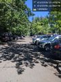
| + | Image:2022-08-06_47_-122_coyotebush_1659827008953.jpg|Arrived exactly at 4 | ||
| + | |||
| + | Image:2022-08-06_47_-122_coyotebush_1659827033840.jpg|Around here [https://openstreetmap.org/?mlat=47.67373611&mlon=-122.19331389&zoom=16 @47.6737,-122.1933] | ||
| + | |||
| + | Image:2022-08-06_47_-122_coyotebush_1659827222597.jpg|Selfie [https://openstreetmap.org/?mlat=47.67374444&mlon=-122.19326667&zoom=16 @47.6737,-122.1933] | ||
| + | |||
| + | |||
</gallery> | </gallery> | ||
| Line 40: | Line 59: | ||
<!-- Add any achievement ribbons you earned below, or remove this section --> | <!-- Add any achievement ribbons you earned below, or remove this section --> | ||
| − | + | {{bicycle geohash | |
| − | + | ||
| − | + | | latitude = 47 | |
| + | | longitude = -122 | ||
| + | | date = 2022-08-06 | ||
| + | | name = coyotebush | ||
| + | | distance = 55 km | ||
| + | | bothways = true | ||
| − | + | }} | |
| + | |||
| + | {{XKCD Centurion | ||
| + | |||
| + | | count = 4 | ||
| + | | name = coyotebush | ||
| + | |||
| + | }} | ||
<!-- Potential categories. Please include all the ones appropriate to your expedition --> | <!-- Potential categories. Please include all the ones appropriate to your expedition --> | ||
| − | |||
| − | |||
| − | |||
| − | |||
| − | |||
[[Category:Expeditions]] | [[Category:Expeditions]] | ||
| − | |||
[[Category:Expeditions with photos]] | [[Category:Expeditions with photos]] | ||
| − | |||
| − | |||
| − | |||
| − | |||
| − | |||
[[Category:Coordinates reached]] | [[Category:Coordinates reached]] | ||
| − | + | {{location|US|WA|KN}} | |
| − | |||
| − | |||
| − | |||
| − | |||
| − | |||
| − | |||
| − | |||
| − | |||
| − | |||
| − | |||
| − | |||
| − | |||
| − | |||
| − | |||
| − | |||
| − | |||
| − | |||
Revision as of 19:42, 7 August 2022
| Sat 6 Aug 2022 in 47,-122: 47.6737517, -122.1933049 geohashing.info google osm bing/os kml crox |
Location
North parking lot of Everest Park in Kirkland.
Participants
Plans
Incorporate a visit into a bike ride, probably aiming for 4pm.
Expedition
I had been looking for some structure to this day, and the Algorithm provided that with a hashpoint close to a great bike route.
I left Fremont at exactly 3pm in the heat of the day. Wind out of the northwest gave me a boost across the 520 bridge trail. The Blue Angels roared overhead for their Seafair show, and the trail was unusually crowded with people watching, but I didn't have much time to stop for photos.
From the 520 trail, I climbed a hill to the Cross Kirkland Corridor for some nice gravel, then just after the Google campus (and a pleasant-looking spot with beer served from a caboose) cut across 5th Ave S to the park. It was exactly 4pm when I arrived at the parking lot. Took some photos, then sat in the shade for 30 minutes in case anyone else showed up, but only saw a bunch of families returning to their cars after a (softball?) game.
I rolled into downtown Kirkland for a cold treat, then returned home via Juanita Drive, Kenmore, and the (blissfully shady by this time) Burke-Gilman Trail.
Photos
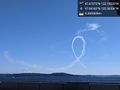
Blue Angels making trails in the sky @47.6416,-122.2634
Arrived exactly at 4
Around here @47.6737,-122.1933
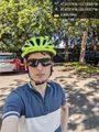
Selfie @47.6737,-122.1933


Achievements
coyotebush earned the Bicycle geohash achievement
|
coyotebush earned the xkcd Nullaturion achievement
|