Difference between revisions of "2022-08-08 58 6"
From Geohashing
(→Photos) |
m (Location) |
||
| (6 intermediate revisions by 2 users not shown) | |||
| Line 27: | Line 27: | ||
== Expedition == | == Expedition == | ||
<!-- how it all turned out. your narrative goes here. --> | <!-- how it all turned out. your narrative goes here. --> | ||
| + | Today the trip to Egersund took place in fine summer weather. We found a place suitable for parking so I asked a lady nearby if we could park there. She smiled at us and said that of course we could park there. From the parking lot to the hash, it was about 800 meters of tractor road almost all the way to the hash. Back at the parking lot, the nice lady came and invited us over to her terrace to show us the wonderful view out to sea. After a short while we said thank you and decided it was time to move on. | ||
== Tracklog == | == Tracklog == | ||
| Line 38: | Line 39: | ||
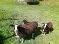
Image:2022-08-08_58_6_Pica42_1659952799381.jpg|Åse [https://openstreetmap.org/?mlat=58.40879740&mlon=6.04210170&zoom=16 @58.4088,6.0421] | Image:2022-08-08_58_6_Pica42_1659952799381.jpg|Åse [https://openstreetmap.org/?mlat=58.40879740&mlon=6.04210170&zoom=16 @58.4088,6.0421] | ||
| − | Image:Screenshot Åse @58.4088,6.0421.jpg| | + | Image:Screenshot Åse @58.4088,6.0421.jpg|Åse [https://openstreetmap.org/?mlat=58.40879740&mlon=6.04210170&zoom=16 @58.4088,6.0421] |
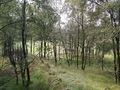
Image:20220808 58 5 01.jpg|On the way to the hash. | Image:20220808 58 5 01.jpg|On the way to the hash. | ||
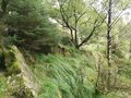
Image:20220808 58 5 02.jpg|View from the hash to the southwest. | Image:20220808 58 5 02.jpg|View from the hash to the southwest. | ||
Image:20220808 58 5 03.jpg|View from the hash to the northeast. | Image:20220808 58 5 03.jpg|View from the hash to the northeast. | ||
| − | Image:20220808 58 5 04.jpg|Me | + | Image:20220808 58 5 04.jpg|Me at the hash. |
</gallery> | </gallery> | ||
| Line 51: | Line 52: | ||
{{land geohash |name=[[User:Pica42|Pica42]] |date=2022-08-03 |latitude=58 |longitude=5 }} | {{land geohash |name=[[User:Pica42|Pica42]] |date=2022-08-03 |latitude=58 |longitude=5 }} | ||
| − | |||
| − | |||
| − | |||
| − | |||
| − | |||
| − | |||
| − | |||
| − | |||
| − | |||
| − | |||
| − | |||
| − | |||
| − | |||
| − | |||
| − | |||
[[Category:Expeditions]] | [[Category:Expeditions]] | ||
| − | |||
[[Category:Expeditions with photos]] | [[Category:Expeditions with photos]] | ||
| − | |||
| − | |||
| − | |||
| − | |||
| − | |||
[[Category:Coordinates reached]] | [[Category:Coordinates reached]] | ||
| − | + | {{location|NO|11}} | |
| − | |||
| − | |||
| − | |||
| − | |||
| − | |||
| − | |||
| − | |||
| − | |||
| − | |||
| − | |||
| − | |||
| − | |||
| − | |||
| − | |||
| − | |||
| − | |||
| − | |||
Latest revision as of 19:42, 8 August 2022
| Mon 8 Aug 2022 in 58,6: 58.4088418, 6.0421012 geohashing.info google osm bing/os kml crox |
Location
Åse, Egersund, Norway
Participants
Plans
Expedition
Today the trip to Egersund took place in fine summer weather. We found a place suitable for parking so I asked a lady nearby if we could park there. She smiled at us and said that of course we could park there. From the parking lot to the hash, it was about 800 meters of tractor road almost all the way to the hash. Back at the parking lot, the nice lady came and invited us over to her terrace to show us the wonderful view out to sea. After a short while we said thank you and decided it was time to move on.
Tracklog
Photos

Åse @58.4088,6.0421

Åse @58.4088,6.0421
On the way to the hash.
View from the hash to the southwest.
View from the hash to the northeast.
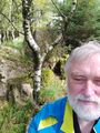
Me at the hash.


Achievements
Pica42 earned the Land geohash achievement
|