Difference between revisions of "2022-10-24 51 -1"
(Add silly grin) |
|||
| Line 3: | Line 3: | ||
|lon=-1 | |lon=-1 | ||
|date=2022-10-24 | |date=2022-10-24 | ||
| − | }} | + | }} __NOTOC__ |
| − | __NOTOC__ | ||
== Location == | == Location == | ||
Wharf Stream Way, Eynsham. I've visited this circular footpath many times to walk the dog or to take the children to swim in the river. | Wharf Stream Way, Eynsham. I've visited this circular footpath many times to walk the dog or to take the children to swim in the river. | ||
== Participants == | == Participants == | ||
| − | *[[User:DanQ| | + | *[[User:DanQ|Dan Q]] |
== Plans == | == Plans == | ||
| − | I hope to cycle/walk to the GZ about lunchtime? | + | <strike>I hope to cycle/walk to the GZ about lunchtime?</strike> I've an opportunity to pass nearby the GZ between other errands this morning! |
== Expedition == | == Expedition == | ||
| − | + | I was excited to see this spot pop up on my radar, because it's a lovely meadow that I've ocassionally walked my dog in, within comfortable cycling distance of my house. As it happened, I had an even easier route here because a drive this morning to drop the kids off at a half-term activity | |
| + | took me "close enough" to be worth stopping and walking from there. | ||
| + | |||
| + | I parked at [https://www.arkells.com/pub/the-talbot-inn-eynsham.htm The Talbot Inn], just West of the [https://en.wikipedia.org/wiki/Swinford_Toll_Bridge Swinford Toll Bridge] (a bizzare old bridge that, for weird historical reasons, continues to use human operators to charge 5 pence per car to cross, which surely cannot be cost-effective!). From here, there's a footpath along the back of the Seimens buildings in the nearby light industrial estate which eventually comes out into the Wharf Stream Way circular walk. It was pretty damp out here today and I quickly regretted my choice of light trousers which would have been fine to drive the kids to their camp and back but wasn't really a good choice for stomping across the long grass of a damp meadow. Some way across I disturbed some grazing deer, but ultimatey it was following a deer-trodden trail that eventually provided the best route to the GZ. | ||
| + | |||
| + | I reached the GZ at 09:19, took a selfie, and then turned around to go and get to work. I also shot a video covering the whole expedition which is presented, unedited, below. | ||
== Tracklog == | == Tracklog == | ||
| − | + | My GPSr kept a tracklog; note that this was an "on the way" stopoff so the start and end point isn't the same! | |
| + | |||
| + | {{ tracklog | Track_2022-10-24 51 -1 HASH.gpx }} | ||
| + | |||
| + | - Download: [[:File:Track_2022-10-24 51 -1 HASH.gpx]] | ||
== Photos == | == Photos == | ||
| − | |||
| − | |||
| − | |||
<gallery perrow='5'> | <gallery perrow='5'> | ||
Image:20221024_091904.jpg | Sily grin | Image:20221024_091904.jpg | Sily grin | ||
</gallery> | </gallery> | ||
| − | == Achievements == | + | == Video == |
| + | I made a video of my expedition! This one's recorded and uploaded entirely "in the field", and completely unedited: sorry if it's a bit rough! | ||
| + | |||
| + | <youtube>https://www.youtube.com/watch?v=yw-DYWFnKWeks0</youtube> | ||
| + | - [https://www.youtube.com/watch?v=yw-DYWFnKWeks0 Via YouTube]. | ||
| + | |||
| + | <!-- == Achievements == --> | ||
{{#vardefine:ribbonwidth|100%}} | {{#vardefine:ribbonwidth|100%}} | ||
<!-- Add any achievement ribbons you earned below, or remove this section --> | <!-- Add any achievement ribbons you earned below, or remove this section --> | ||
| − | |||
| − | |||
| − | |||
| − | |||
| − | |||
| − | |||
| − | |||
| − | |||
| − | |||
| − | |||
| − | |||
| − | |||
| − | |||
| − | |||
[[Category:Expeditions]] | [[Category:Expeditions]] | ||
| − | |||
[[Category:Expeditions with photos]] | [[Category:Expeditions with photos]] | ||
[[Category:Expeditions with videos]] | [[Category:Expeditions with videos]] | ||
| − | |||
| − | |||
| − | |||
| − | |||
[[Category:Coordinates reached]] | [[Category:Coordinates reached]] | ||
| − | |||
| − | |||
| − | |||
| − | |||
| − | |||
| − | |||
| − | |||
| − | |||
| − | |||
| − | |||
| − | |||
| − | |||
| − | |||
| − | |||
| − | |||
| − | |||
| − | |||
| − | |||
Revision as of 09:04, 24 October 2022
| Mon 24 Oct 2022 in 51,-1: 51.7782009, -1.3564190 geohashing.info google osm bing/os kml crox |
Location
Wharf Stream Way, Eynsham. I've visited this circular footpath many times to walk the dog or to take the children to swim in the river.
Participants
Plans
I hope to cycle/walk to the GZ about lunchtime? I've an opportunity to pass nearby the GZ between other errands this morning!
Expedition
I was excited to see this spot pop up on my radar, because it's a lovely meadow that I've ocassionally walked my dog in, within comfortable cycling distance of my house. As it happened, I had an even easier route here because a drive this morning to drop the kids off at a half-term activity took me "close enough" to be worth stopping and walking from there.
I parked at The Talbot Inn, just West of the Swinford Toll Bridge (a bizzare old bridge that, for weird historical reasons, continues to use human operators to charge 5 pence per car to cross, which surely cannot be cost-effective!). From here, there's a footpath along the back of the Seimens buildings in the nearby light industrial estate which eventually comes out into the Wharf Stream Way circular walk. It was pretty damp out here today and I quickly regretted my choice of light trousers which would have been fine to drive the kids to their camp and back but wasn't really a good choice for stomping across the long grass of a damp meadow. Some way across I disturbed some grazing deer, but ultimatey it was following a deer-trodden trail that eventually provided the best route to the GZ.
I reached the GZ at 09:19, took a selfie, and then turned around to go and get to work. I also shot a video covering the whole expedition which is presented, unedited, below.
Tracklog
My GPSr kept a tracklog; note that this was an "on the way" stopoff so the start and end point isn't the same!
- Download: File:Track_2022-10-24 51 -1 HASH.gpx
Photos
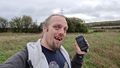
Sily grin

Video
I made a video of my expedition! This one's recorded and uploaded entirely "in the field", and completely unedited: sorry if it's a bit rough!
- Via YouTube.