Difference between revisions of "2022-11-11 45 -122"
Michael5000 (talk | contribs) (→Participants) |
Michael5000 (talk | contribs) |
||
| Line 20: | Line 20: | ||
*[[user:Michael5000|Michael5000]] | *[[user:Michael5000|Michael5000]] | ||
| − | == | + | == Expedition == |
| − | + | ||
| + | It's the Veteran's Day holiday here in the United States of America, and although it was a cold day here in Portland (44 F, that's... hang on... 44-32=12, 12/9=1.333, times 5 is like 7 C, I think? Chilly, at any rate) at least the rain was holding off and the streets were dryish, so how could I ''not'' jump on the bicycle and give this hashpoint a try? Well, actually I had no trouble at all coming up with several terrific reasons not to do that very thing, but in the end I managed to shove myself out the door. | ||
| + | |||
| + | Turns out I was a bit underdressed, so the uphill stretches were comfortable but the downhill stretches were rather bracing, tending towards painful. But that which does not kill me makes me stronger. Or perhaps hastens my decline. Who can say? | ||
| + | |||
| + | I ran into Meaghan about ten minutes in, but I was very discrete and didn't mention that I was on a geohashing expedition. She was on foot and naturally would have been disappointed about not being able to join in on such an exciting venture. | ||
| + | |||
| + | After crossing the river and passing through downtown, I took the lovely and mostly-bicycle-friendly Terwilliger Avenue up, up, up to near the Lewis and Clark College campus (one of my ''almae maters''), and then the last stretch was on a trail within the park. The actual hashpoint required a little tramping around in the forest, but nothing too arduous. I made a big "X" with two pieces of wood, then consulted my GPS and saw that I was a bit off point, found the actual hashpoint, took pictures, and forgot all about the big "X". So, I left absolutely nothing at the hashpoint, but a big "X" at a yet more random place near the hashpoint. That's geohashing for you. | ||
| − | + | Then I went home, more or less the same route in reverse, 19 miles all told. Thats, hang on... nineteen times six is 114, 190 and 114 is... 30.4, yeah, roughly 30 kilometers, that sounds right. So, a long ways on a cold day. It took about 45 minutes before all of my toes were ready to report back in. | |
| − | |||
| − | |||
| − | |||
== Photos == | == Photos == | ||
| − | |||
| − | |||
| − | |||
<gallery perrow="5"> | <gallery perrow="5"> | ||
| + | File:45 -122 2022-11-11 1.jpg|View of downtown from the Hawthorne Bridge | ||
| + | File:45 -122 2022-11-11 2.jpg|Leaving my bike for final approach | ||
| + | File:45 -122 2022-11-11 3.jpg|View from the hashpoint | ||
| + | File:45 -122 2022-11-11 4.jpg|Me looking a bit smug at the hashpoint | ||
| + | File:45 -122 2022-11-11 5.jpg|This was a hashcot-certified expedition | ||
</gallery> | </gallery> | ||
== Achievements == | == Achievements == | ||
{{#vardefine:ribbonwidth|100%}} | {{#vardefine:ribbonwidth|100%}} | ||
| − | |||
| − | |||
| − | |||
| − | |||
| − | |||
| − | |||
| − | |||
| − | |||
| − | |||
| − | |||
| − | |||
| − | |||
| − | |||
| − | |||
| − | |||
| − | |||
| − | |||
[[Category:Expeditions]] | [[Category:Expeditions]] | ||
| − | |||
[[Category:Expeditions with photos]] | [[Category:Expeditions with photos]] | ||
| − | |||
| − | |||
| − | |||
| − | |||
| − | |||
[[Category:Coordinates reached]] | [[Category:Coordinates reached]] | ||
| − | |||
| − | |||
| − | |||
| − | |||
| − | |||
| − | |||
| − | |||
| − | |||
| − | |||
| − | |||
| − | |||
| − | |||
| − | |||
| − | |||
| − | |||
| − | |||
| − | |||
| − | |||
Revision as of 04:39, 12 November 2022
| Fri 11 Nov 2022 in 45,-122: 45.4467954, -122.6772383 geohashing.info google osm bing/os kml crox |
Location
In Tryon Creek State Park, not far from 2019-05-25 45 -122.
Participants
Expedition
It's the Veteran's Day holiday here in the United States of America, and although it was a cold day here in Portland (44 F, that's... hang on... 44-32=12, 12/9=1.333, times 5 is like 7 C, I think? Chilly, at any rate) at least the rain was holding off and the streets were dryish, so how could I not jump on the bicycle and give this hashpoint a try? Well, actually I had no trouble at all coming up with several terrific reasons not to do that very thing, but in the end I managed to shove myself out the door.
Turns out I was a bit underdressed, so the uphill stretches were comfortable but the downhill stretches were rather bracing, tending towards painful. But that which does not kill me makes me stronger. Or perhaps hastens my decline. Who can say?
I ran into Meaghan about ten minutes in, but I was very discrete and didn't mention that I was on a geohashing expedition. She was on foot and naturally would have been disappointed about not being able to join in on such an exciting venture.
After crossing the river and passing through downtown, I took the lovely and mostly-bicycle-friendly Terwilliger Avenue up, up, up to near the Lewis and Clark College campus (one of my almae maters), and then the last stretch was on a trail within the park. The actual hashpoint required a little tramping around in the forest, but nothing too arduous. I made a big "X" with two pieces of wood, then consulted my GPS and saw that I was a bit off point, found the actual hashpoint, took pictures, and forgot all about the big "X". So, I left absolutely nothing at the hashpoint, but a big "X" at a yet more random place near the hashpoint. That's geohashing for you.
Then I went home, more or less the same route in reverse, 19 miles all told. Thats, hang on... nineteen times six is 114, 190 and 114 is... 30.4, yeah, roughly 30 kilometers, that sounds right. So, a long ways on a cold day. It took about 45 minutes before all of my toes were ready to report back in.
Photos
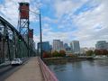
View of downtown from the Hawthorne Bridge
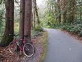
Leaving my bike for final approach
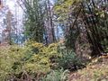
View from the hashpoint
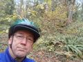
Me looking a bit smug at the hashpoint
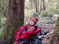
This was a hashcot-certified expedition


