Difference between revisions of "2023-03-10 51 -1"
(Created page with "{{meetup graticule |lat=51 |lon=-1 |date=2023-03-10 }} == Location == [https://northleighparishcouncil.gov.uk/amenity/north-leigh-common/ North Leigh Common], West Oxfordshire...") |
(Successful expedition!) |
||
| Line 14: | Line 14: | ||
== Expedition == | == Expedition == | ||
| − | + | Our dog had surgery at the start of the week and has now recovered enough to want a short walk, so I changed my plan to cycle for one to drive (with the dog) out to somewhere near the hashpoint and take her for a walk to and around it. Amazingly, I might have been faster to cycle: a crash on the A40 had lead to lots of traffic being re-routed along the exact same back roads that was to be my most-direct route, and on the local rat run through South Leigh I got trapped behind a line of folks who weren't familiar with this particular unlit and twisty road and took the entire derestricted section at an average of 25mph. Ah well. | |
| − | + | Out of laziness, I didn't bring my GPSr or make a tracklog; I just used the Geohashdroid app and took a screenshot when I got there. South Leigh Common is pleasant, but it was dark, and my photos are all a little bit hard to make out! But the stars were beautiful tonight, and the dog loved one of her first outings since her surgery and enjoying running around in the long wet grass and sticking her head into rabbit holes. At 19:00 precisely I got within about a metre and a half of the hashpoint - well within the circle of uncertainty - and turned to head home. | |
| − | + | ||
| + | I also took the time while there to [https://www.openstreetmap.org/changeset/133510299 update OpenStreetMap] by drawing in the boundaries of the common, replacing the nondescript "point" that had marked it before. | ||
== Photos == | == Photos == | ||
| − | < | + | <gallery perrow='3'> |
| − | Image: | + | Image:Screenshot_20230310_190035_Geohash Droid.png | Proof from Geohashdroid |
| − | + | Image:20230310_190109.jpg | Silly grins in the dark from a man and his dog | |
| − | + | Image:20230310_190209.jpg | Long exposure, with flashlight on, showing the hashpoint and the Common beyond | |
</gallery> | </gallery> | ||
| − | |||
| − | |||
| − | |||
| − | |||
| − | |||
| − | |||
| − | |||
| − | |||
| − | |||
| − | |||
| − | |||
| − | |||
| − | |||
| − | |||
| − | |||
| − | |||
| − | |||
| − | |||
[[Category:Expeditions]] | [[Category:Expeditions]] | ||
| − | |||
[[Category:Expeditions with photos]] | [[Category:Expeditions with photos]] | ||
| − | |||
| − | |||
| − | |||
| − | |||
| − | |||
[[Category:Coordinates reached]] | [[Category:Coordinates reached]] | ||
| − | |||
| − | |||
| − | |||
| − | |||
| − | |||
| − | |||
| − | |||
| − | |||
| − | |||
| − | |||
| − | |||
| − | |||
| − | |||
| − | |||
| − | |||
| − | |||
| − | |||
| − | |||
__NOTOC__ | __NOTOC__ | ||
Revision as of 19:42, 10 March 2023
| Fri 10 Mar 2023 in 51,-1: 51.8201826, -1.4209405 geohashing.info google osm bing/os kml crox |
Location
North Leigh Common, West Oxfordshire.
Participants
Plans
My evening just freed up, so - weather-permitting - I might brave the sleet and cold and cycle out to this hashpoint this evening.
Expedition
Our dog had surgery at the start of the week and has now recovered enough to want a short walk, so I changed my plan to cycle for one to drive (with the dog) out to somewhere near the hashpoint and take her for a walk to and around it. Amazingly, I might have been faster to cycle: a crash on the A40 had lead to lots of traffic being re-routed along the exact same back roads that was to be my most-direct route, and on the local rat run through South Leigh I got trapped behind a line of folks who weren't familiar with this particular unlit and twisty road and took the entire derestricted section at an average of 25mph. Ah well.
Out of laziness, I didn't bring my GPSr or make a tracklog; I just used the Geohashdroid app and took a screenshot when I got there. South Leigh Common is pleasant, but it was dark, and my photos are all a little bit hard to make out! But the stars were beautiful tonight, and the dog loved one of her first outings since her surgery and enjoying running around in the long wet grass and sticking her head into rabbit holes. At 19:00 precisely I got within about a metre and a half of the hashpoint - well within the circle of uncertainty - and turned to head home.
I also took the time while there to update OpenStreetMap by drawing in the boundaries of the common, replacing the nondescript "point" that had marked it before.
Photos

Proof from Geohashdroid

Silly grins in the dark from a man and his dog
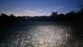
Long exposure, with flashlight on, showing the hashpoint and the Common beyond


