Difference between revisions of "2023-04-10 -41 145"
([retro picture]Wallaby) |
m (Location) |
||
| (10 intermediate revisions by one other user not shown) | |||
| Line 1: | Line 1: | ||
| − | + | [[Image:{{{image|2023-04-10_-41_145_Johnwrw_1681122328312.jpg}}}|thumb|left]] | |
| − | + | {{meetup graticule | |
| − | [[Image:{{{image| | ||
| − | |||
| − | |||
| − | |||
| − | |||
| − | |||
| − | |||
| lat=-41 | | lat=-41 | ||
| lon=145 | | lon=145 | ||
| date=2023-04-10 | | date=2023-04-10 | ||
| − | }} | + | }} |
== Location == | == Location == | ||
| − | + | A few hundred metres off the road in the Vale of Belvoir conservation area, north of Cradle Mountain | |
== Participants == | == Participants == | ||
| − | + | *[[User:Johnwrw|John]] | |
| − | - | + | *Bridget |
| + | |||
| + | == Expedition == | ||
| + | Bridget and I were again down in Tasmania, about a year after [[2022-03-23_-41_145|our first hash]] in this graticule. We were spending a week at Sisters Beach over Easter. We already had plans for a day trip at some point to Cradle Mountain, and when on Friday we were blessed with 4 days' hashpoints at once, we saw how Monday's hash was just off the very road we needed to take to Cradle. Obviously Monday would have to be the day to visit Cradle, and then we could have a go at the hash at the same time. | ||
| + | |||
| + | We wanted to set off from from Sisters nice and early, with about two hours driving ahead of us, and with plans for a big walk at Cradle on top of the hash attempt, and we succeeded here, departing at 8:30. At about a quarter past 10 we arrived at the hash vicinity. We overshot slightly, but after chucking a Uey, we found somewhere to pull over on the side of the road. | ||
| + | |||
| + | A few hundred metres of bush that looked tricky to bash lay between us and the hash, but luckily, just to the west there was cleared land, possibly where livestock might occasionally be run, that could get us much closer. | ||
| + | |||
| + | We snuck through a rusty barbed wire fence, that fortunately had very loose wires, and made our way across the very damp land, dodging the most beautiful pristine little mossy pools that were everywhere we looked. The day was gorgeous, the sun was shining, the birds were calling (including Black Currawongs, which have a much harsher call than their mainland cousins). We stomped up to slightly higher ground and joined an old vehicle track, that was quite overgrown but still quite easy to follow. As we mounted a crest we saw wallabies before us before they made themselves scarce, but not before I snapped a pic. | ||
| + | |||
| + | Soon we were at the point that we had to leave this track and delve into the forest. But now it was only about 70m of bush bashing that was necessary. We were concerned at how thick it looked from the outside, but once we breached the threshold, it was open enough under the trees. We made good time, despite getting slightly disoriented due to the poorer GPS signal beneath the canopy, but soon we reached a little open area where we found the hash, after a little stomping around GPS-dancing. | ||
| + | |||
| + | After a selfie we made back for the vehicle track in a slightly more direct fashion, and then marched down the hill to the pristine pools, slunk through the fence, and reached the car again totalling only about half an hour or so all up for this little hashy diversion on our way to Cradle. | ||
| − | + | Bridget gave the whole expedition two thumbs up, and said it might even have helped heal the trauma of the last Tasmanian hash where we bashed around in the rainforest for over two hours, and she had began to wonder if we would ever get out to tell the tale. | |
| − | |||
| − | + | We continued on our way to Cradle, only about 15 minutes away at this point, and proceeded to do a very nice walk. We did a loop up to Marion's Lookout, where there was still some snow on the ground, despite the full sun depleting its quantity at an incredible rate, and making the track up resemble more a creek than a path at stages. We then followed this up by doing the Dove Lake circuit which was as delightful as it always is. | |
| − | |||
| − | + | We eventually returned to Sisters Beach at about 7:30, and as after our last Tassie hash, we had noodles for dinner. | |
| − | |||
== Photos == | == Photos == | ||
| Line 33: | Line 36: | ||
--> | --> | ||
<gallery perrow="5"> | <gallery perrow="5"> | ||
| + | Image:2023-04-10_-41_145_Johnwrw_1681882597184.jpg|Pristine pool | ||
| + | |||
| + | Image:2023-04-10_-41_145_Johnwrw_1681882907812.jpg|Overgrown vehicle track | ||
| + | |||
| + | Image:2023-04-10_-41_145_Johnwrw_1681882653910.jpg|Wallaby | ||
| + | |||
| + | Image:2023-04-10_-41_145_Johnwrw_1681882716514.jpg|In the trees, not too bad as far as bushbashing goes | ||
Image:2023-04-10_-41_145_Johnwrw_1681122328312.jpg|Success! | Image:2023-04-10_-41_145_Johnwrw_1681122328312.jpg|Success! | ||
| + | |||
| + | Image:2023-04-10_-41_145_Johnwrw_1681882737275.jpg|View from hash | ||
| + | |||
| + | Image:2023-04-10_-41_145_Johnwrw_1681882776918.jpg|Satisfied Bridget after a less traumatic hash | ||
| + | |||
| + | Image:2023-04-10_-41_145_Johnwrw_1681882791176.jpg|Back to the car | ||
Image:2023-04-10_-41_145_Johnwrw_1681122392270.jpg|GPS proof | Image:2023-04-10_-41_145_Johnwrw_1681122392270.jpg|GPS proof | ||
| − | |||
| − | Image:2023-04-10_- | + | Image:2023-04-10_-41_145_Johnwrw_1681883726292.jpg|Snow |
| + | |||
| + | Image:2023-04-10_-41_145_Johnwrw_1681883819124.jpg|A pool | ||
| − | Image:2023-04-10_- | + | Image:2023-04-10_-41_145_Johnwrw_1681883831922.jpg|The mountain |
</gallery> | </gallery> | ||
| − | |||
| − | |||
| − | |||
| − | |||
__NOTOC__ | __NOTOC__ | ||
| − | |||
| − | |||
| − | |||
| − | |||
| − | |||
| − | |||
| − | |||
| − | |||
| − | |||
| − | |||
[[Category:Expeditions]] | [[Category:Expeditions]] | ||
| − | + | ||
[[Category:Expeditions with photos]] | [[Category:Expeditions with photos]] | ||
| − | + | ||
| − | |||
| − | |||
| − | |||
| − | |||
[[Category:Coordinates reached]] | [[Category:Coordinates reached]] | ||
| − | + | {{location|AU|TAS|KE}} | |
| − | |||
| − | |||
| − | |||
| − | |||
| − | |||
| − | |||
| − | |||
| − | |||
| − | |||
| − | |||
| − | |||
| − | |||
| − | |||
| − | |||
| − | |||
| − | |||
| − | |||
Latest revision as of 06:42, 19 April 2023

| Mon 10 Apr 2023 in -41,145: -41.5531272, 145.9358337 geohashing.info google osm bing/os kml crox |
Location
A few hundred metres off the road in the Vale of Belvoir conservation area, north of Cradle Mountain
Participants
- John
- Bridget
Expedition
Bridget and I were again down in Tasmania, about a year after our first hash in this graticule. We were spending a week at Sisters Beach over Easter. We already had plans for a day trip at some point to Cradle Mountain, and when on Friday we were blessed with 4 days' hashpoints at once, we saw how Monday's hash was just off the very road we needed to take to Cradle. Obviously Monday would have to be the day to visit Cradle, and then we could have a go at the hash at the same time.
We wanted to set off from from Sisters nice and early, with about two hours driving ahead of us, and with plans for a big walk at Cradle on top of the hash attempt, and we succeeded here, departing at 8:30. At about a quarter past 10 we arrived at the hash vicinity. We overshot slightly, but after chucking a Uey, we found somewhere to pull over on the side of the road.
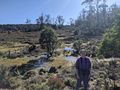
A few hundred metres of bush that looked tricky to bash lay between us and the hash, but luckily, just to the west there was cleared land, possibly where livestock might occasionally be run, that could get us much closer.
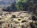
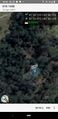
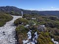
We snuck through a rusty barbed wire fence, that fortunately had very loose wires, and made our way across the very damp land, dodging the most beautiful pristine little mossy pools that were everywhere we looked. The day was gorgeous, the sun was shining, the birds were calling (including Black Currawongs, which have a much harsher call than their mainland cousins). We stomped up to slightly higher ground and joined an old vehicle track, that was quite overgrown but still quite easy to follow. As we mounted a crest we saw wallabies before us before they made themselves scarce, but not before I snapped a pic.
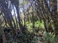
Soon we were at the point that we had to leave this track and delve into the forest. But now it was only about 70m of bush bashing that was necessary. We were concerned at how thick it looked from the outside, but once we breached the threshold, it was open enough under the trees. We made good time, despite getting slightly disoriented due to the poorer GPS signal beneath the canopy, but soon we reached a little open area where we found the hash, after a little stomping around GPS-dancing.
After a selfie we made back for the vehicle track in a slightly more direct fashion, and then marched down the hill to the pristine pools, slunk through the fence, and reached the car again totalling only about half an hour or so all up for this little hashy diversion on our way to Cradle.
Bridget gave the whole expedition two thumbs up, and said it might even have helped heal the trauma of the last Tasmanian hash where we bashed around in the rainforest for over two hours, and she had began to wonder if we would ever get out to tell the tale.
We continued on our way to Cradle, only about 15 minutes away at this point, and proceeded to do a very nice walk. We did a loop up to Marion's Lookout, where there was still some snow on the ground, despite the full sun depleting its quantity at an incredible rate, and making the track up resemble more a creek than a path at stages. We then followed this up by doing the Dove Lake circuit which was as delightful as it always is.
We eventually returned to Sisters Beach at about 7:30, and as after our last Tassie hash, we had noodles for dinner.
Photos
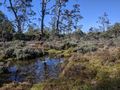
Pristine pool
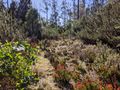
Overgrown vehicle track
Wallaby
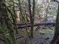
In the trees, not too bad as far as bushbashing goes
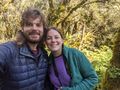
Success!
View from hash
Satisfied Bridget after a less traumatic hash
Back to the car
GPS proof
Snow
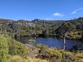
A pool
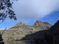
The mountain


