Difference between revisions of "2023-04-23 45 -122"
([retro picture]Michael is here!) |
Michael5000 (talk | contribs) (→Michael5000) |
||
| (12 intermediate revisions by 3 users not shown) | |||
| Line 1: | Line 1: | ||
| − | + | [[Image:{{{image|2023-04-23 45 -122 frogman 1682374251984.jpg}}}|thumb|left]] | |
| − | + | {{meetup graticule | |
| − | [[Image:{{{image| | ||
| − | |||
| − | |||
| − | |||
| − | |||
| − | |||
| − | |||
| lat=45 | | lat=45 | ||
| lon=-122 | | lon=-122 | ||
| Line 13: | Line 6: | ||
}}<!-- edit as necessary --> | }}<!-- edit as necessary --> | ||
== Location == | == Location == | ||
| − | + | Just north of the Marine Drive multi-use trail, near the airport. | |
== Participants == | == Participants == | ||
| − | + | *[[User:Frogman|Frogman]] | |
| − | + | *[[User:Higgs|Higgs]] | |
| + | *[[User:Michael5000|Michael5000]] | ||
== Plans == | == Plans == | ||
| − | + | Frogman texted Michael5000 "Geohashing Sunday?" and Michael5000 replied "Looks that way!" | |
== Expedition == | == Expedition == | ||
| − | + | ===Frogman and Higgs=== | |
| + | Due to track upgrades, the MAX was out between 7th Avenue and Gateway Transit Center with shuttle bus service between the two. The shuttle bus was a bit slow and meandering, as the intermediate stations' location in the I-84 right-of-way places the station entrances out of the way of normal traffic. At Gateway, one of the customer service agents came and chatted with us about the ongoing construction, specifically pointing out the cool tie-placing machine. They seem to be coming along nicely! | ||
| − | == | + | After a bit we caught the Red Line up to Mt. Hood Avenue MAX station, giving us the prestigious honor of being the only people in history to use Mt. Hood Avenue MAX station. Michael was there, having arrived on bicycle. We walked along some roads to get to the rather nice multi-use path, which sits between Marine Drive and the Columbia River. The proximity to the airport meant we got some nice (if loud) views of airplanes taking off. |
| − | + | ||
| + | The hashpoint itself is just north of the path. We snapped some pics and then parted ways. | ||
| + | |||
| + | ===Michael5000=== | ||
| + | |||
| + | It was pretty much like they said. It was the first viable hashpoint in Portland in about 6 million years; hopefully, the first of a bountiful spring glut. Riding from home to the not-bustling Mt. Hood Avenue station, and then from the hashpoint around the west end of the airport, was an 18.8 mile ride, so that was pretty good. | ||
| + | |||
| + | This was the third hashpoint I've biked to on the Columbia River Trail, less then 100 meters from [[2011-02-26 45 -122]] although considerably warmer. Another 1.9 miles to the east, there was [[2010-07-17 45 -122]]. Plus, not far from there, there was [[2011-06-17 45 -122]], a hashpoint on Marine Drive that I drove over in my old truck. | ||
== Photos == | == Photos == | ||
| Line 39: | Line 41: | ||
Image:2023-04-23_45_-122_frogman_1682374209461.jpg|Michael is here! | Image:2023-04-23_45_-122_frogman_1682374209461.jpg|Michael is here! | ||
| + | |||
| + | Image:2023-04-23_45_-122_frogman_1682374233741.jpg|Airplane taking off | ||
| + | |||
| + | Image:2023-04-23_45_-122_frogman_1682374251984.jpg|View west from the hashpoint | ||
| + | |||
| + | Image:2023-04-23_45_-122_frogman_1682374261041.jpg|View east | ||
| + | |||
| + | Image:2023-04-23_45_-122_frogman_1682374314002.jpg|The adventurers! | ||
| + | </gallery> | ||
| + | |||
| + | '''Michael5000's photos''' | ||
| + | <gallery perrow="5"> | ||
| + | File:2023-04-23 45 -122 1.jpg|At the MAX stop. | ||
| + | File:2023-04-23 45 -122 2.jpg|Frogman and Higgs are here! | ||
| + | File:2023-04-23 45 -122 3.jpg|Another, very similar, view west from the hashpoint | ||
| + | File:2023-04-23 45 -122 4.jpg|I framed the shot and something distracted both of them. | ||
| + | File:2023-04-23 45 -122 5.jpg|An airplane starting skyward, from the hashpoint. | ||
</gallery> | </gallery> | ||
| Line 44: | Line 63: | ||
{{#vardefine:ribbonwidth|100%}} | {{#vardefine:ribbonwidth|100%}} | ||
<!-- Add any achievement ribbons you earned below, or remove this section --> | <!-- Add any achievement ribbons you earned below, or remove this section --> | ||
| + | {{Public transport geohash | ||
| − | + | | latitude = 45 | |
| − | + | | longitude = -122 | |
| − | + | | date = 2023-04-23 | |
| − | [[ | + | | busline = Trimet |
| − | + | | name = [[User:Frogman|Frogman]] and [[User:Higgs|Higgs]] | |
| − | + | | image = 2023-04-23 45 -122 frogman 1682374142373.jpg | |
| − | + | }} | |
| − | |||
| − | |||
| − | |||
| − | + | __NOTOC__ | |
| − | |||
| − | |||
[[Category:Expeditions]] | [[Category:Expeditions]] | ||
| − | |||
[[Category:Expeditions with photos]] | [[Category:Expeditions with photos]] | ||
| − | |||
| − | |||
| − | |||
| − | |||
| − | |||
[[Category:Coordinates reached]] | [[Category:Coordinates reached]] | ||
| − | + | {{location|US|OR|MU}} | |
| − | |||
| − | |||
| − | |||
| − | |||
| − | |||
| − | |||
| − | |||
| − | |||
| − | |||
| − | |||
| − | |||
| − | |||
| − | |||
| − | |||
| − | |||
| − | |||
| − | |||
Latest revision as of 01:48, 27 April 2023

| Sun 23 Apr 2023 in 45,-122: 45.5851278, -122.5662342 geohashing.info google osm bing/os kml crox |
Location
Just north of the Marine Drive multi-use trail, near the airport.
Participants
Plans
Frogman texted Michael5000 "Geohashing Sunday?" and Michael5000 replied "Looks that way!"
Expedition
Frogman and Higgs
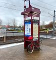
Due to track upgrades, the MAX was out between 7th Avenue and Gateway Transit Center with shuttle bus service between the two. The shuttle bus was a bit slow and meandering, as the intermediate stations' location in the I-84 right-of-way places the station entrances out of the way of normal traffic. At Gateway, one of the customer service agents came and chatted with us about the ongoing construction, specifically pointing out the cool tie-placing machine. They seem to be coming along nicely!
After a bit we caught the Red Line up to Mt. Hood Avenue MAX station, giving us the prestigious honor of being the only people in history to use Mt. Hood Avenue MAX station. Michael was there, having arrived on bicycle. We walked along some roads to get to the rather nice multi-use path, which sits between Marine Drive and the Columbia River. The proximity to the airport meant we got some nice (if loud) views of airplanes taking off.
The hashpoint itself is just north of the path. We snapped some pics and then parted ways.
Michael5000
It was pretty much like they said. It was the first viable hashpoint in Portland in about 6 million years; hopefully, the first of a bountiful spring glut. Riding from home to the not-bustling Mt. Hood Avenue station, and then from the hashpoint around the west end of the airport, was an 18.8 mile ride, so that was pretty good.
This was the third hashpoint I've biked to on the Columbia River Trail, less then 100 meters from 2011-02-26 45 -122 although considerably warmer. Another 1.9 miles to the east, there was 2010-07-17 45 -122. Plus, not far from there, there was 2011-06-17 45 -122, a hashpoint on Marine Drive that I drove over in my old truck.
Photos
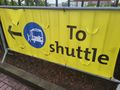
Signage for the MAX shuttle
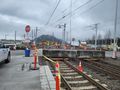
Construction at Gateway Transit Center
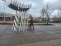
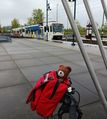
Michael is here!
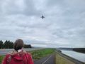
Airplane taking off
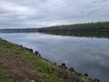
View west from the hashpoint
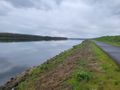
View east
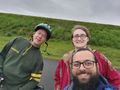
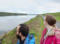
The adventurers!


Michael5000's photos
At the MAX stop.
Frogman and Higgs are here!
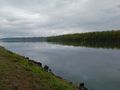
Another, very similar, view west from the hashpoint
I framed the shot and something distracted both of them.
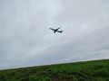
An airplane starting skyward, from the hashpoint.


Achievements
Frogman and Higgs earned the Public transport geohash achievement
|