Difference between revisions of "2023-04-28 43 -119"
Michael5000 (talk | contribs) (→Location) |
m (per Renaming Proposal) |
||
| (8 intermediate revisions by 2 users not shown) | |||
| Line 11: | Line 11: | ||
== Expedition == | == Expedition == | ||
| − | After [[2023-04-28 44 -121]] and stops in Sister and Bend, I headed out into the sparsely inhabited southeast quarter of Oregon on US Highway 20. After 120 miles or so, there's the junction with US 395, and I turned south there and drove down to the same turnoff I used for [[2019-03-23 43 -120|Expedition 207]] -- not at the hashpoint itself, but | + | After [[2023-04-28 44 -121]] and stops in Sister and Bend, I headed out into the sparsely inhabited southeast quarter of Oregon on US Highway 20. After 120 miles or so, there's the junction with US 395, and I turned south there and drove down to the same turnoff I used for [[2019-03-23 43 -120|Expedition 207]] -- not at the hashpoint itself, but the place I stopped before the hashpoint to go running. That time, I ran west up Squaw Butte Road, a well maintained gravel lane. This time, I got out the bicycle and headed east up Big Stick Road, a pair of ruts that clearly hadn't had any human traffic since at least the last time it rained. |
| − | Two and a half miles on the bicycle got me | + | Two and a half miles on the bicycle got me within 1.13 miles of the hashpoint, which was somewhere out there on a plain of sagebrush. Checking the time until sundown and the batteries on my equipment, I headed out. Walking across a sagebrush plain isn't really much harder than walking down a sidewalk, so aside from the curious feeling of vulnerability a city person feels when they can see for a few miles in all directions and yet they are the only person present, it was really little more than a pleasant stroll. Naturally getting to the third hashpoint in one day felt pretty good. |
Back on my bicycle, I came up from the downwind side and startled an antelope grazing by the road. I mean, I was fairly startled too, but the antelope seemed to be well and truly freaked out as it disappeared towards the horizon. Admittedly, antelopes probably didn't have a lot of bicycles in their evolutionary environment. | Back on my bicycle, I came up from the downwind side and startled an antelope grazing by the road. I mean, I was fairly startled too, but the antelope seemed to be well and truly freaked out as it disappeared towards the horizon. Admittedly, antelopes probably didn't have a lot of bicycles in their evolutionary environment. | ||
| Line 22: | Line 22: | ||
<gallery perrow="5"> | <gallery perrow="5"> | ||
| + | File:2023-04-28 43 -119 a.jpg|The starting point on US 395. | ||
| + | File:2023-04-28 43 -119 b.jpg|Through the gate... | ||
| + | File:2023-04-28 43 -119 c.jpg|...and into the desert. | ||
| + | File:2023-04-28 43 -119 d.jpg|Leaving the bicycle for the last stretch. | ||
| + | File:2023-04-28 43 -119 e.jpg|There! | ||
| + | File:2023-04-28 43 -119 f.jpg|Triple-hash satisfaction. | ||
| + | File:2023-04-28 43 -119 g.jpg|Southwest from the hashpoint. | ||
| + | File:2023-04-28 43 -119 h.jpg|Northwest... | ||
| + | File:2023-04-28 43 -119 i.jpg|Northeast, back towards the bike... | ||
| + | File:2023-04-28 43 -119 j.jpg|Southeast. | ||
| + | File:2023-04-28 43 -119 k.jpg|A pretty little flower that lives at the hashpoint. | ||
| + | File:2023-04-28 43 -119 l.jpg|Casting a long shadow. | ||
</gallery> | </gallery> | ||
== Achievements == | == Achievements == | ||
{{#vardefine:ribbonwidth|100%}} | {{#vardefine:ribbonwidth|100%}} | ||
| − | |||
| − | + | {{Graticule unlocked | |
| − | |||
| − | |||
| − | |||
| − | + | | latitude = 43 | |
| + | | longitude = -119 | ||
| + | | date = 2023-04-28 | ||
| + | | name = Michael5000 | ||
| − | + | }} | |
| − | |||
| − | |||
| − | |||
| − | + | {{Multihash2 | |
| − | + | | date = 2023-04-28 | |
| − | + | | count = 3 | |
| − | + | | name = Michael5000 | |
| − | |||
| − | |||
| − | |||
| − | |||
| − | |||
| − | |||
| − | |||
| + | }} | ||
| − | + | ||
| − | [[ | + | {{Minesweeper geohash |
| − | + | | graticule = [[Prineville, Oregon]] | |
| − | + | | ranknumber = 7 | |
| − | [[ | + | | nw = true |
| − | + | | n = true | |
| − | + | | ne = true | |
| − | [[ | + | | w = true |
| + | | sw = true | ||
| + | | s = true | ||
| + | | se = true | ||
| + | | name = [[User:Michael5000|Michael5000]] | ||
| + | }} | ||
| + | {{Minesweeper geohash | ||
| + | | graticule = [[Hampton, Oregon]] | ||
| + | | ranknumber = 6 | ||
| + | | nw = true | ||
| + | | n = true | ||
| + | | w = true | ||
| + | | sw = true | ||
| + | | s = true | ||
| + | | e = true | ||
| + | | name = [[User:Michael5000|Michael5000]] | ||
| + | }} | ||
| + | {{Minesweeper geohash | ||
| + | | graticule = [[Prairie City, Oregon]] | ||
| + | | ranknumber = 6 | ||
| + | | n = true | ||
| + | | ne = true | ||
| + | | nw = true | ||
| + | | se = true | ||
| + | | s = true | ||
| + | | sw = true | ||
| + | | name = [[User:Michael5000|Michael5000]] | ||
| + | }} | ||
| + | {{Minesweeper geohash | ||
| + | | graticule = [[Hines, Oregon]] | ||
| + | | ranknumber = 5 | ||
| + | | sw = true | ||
| + | | w = true | ||
| + | | nw = true | ||
| + | | ne = true | ||
| + | | e = true | ||
| + | | name = [[User:Michael5000|Michael5000]] | ||
| + | }} | ||
| − | + | __NOTOC__ | |
| − | |||
| − | |||
| − | |||
| − | |||
| − | + | [[Category:Expeditions]] | |
| + | [[Category:Expeditions with photos]] | ||
| + | [[Category:Coordinates reached]] | ||
| + | {{location|US|OR|HA}} | ||
Latest revision as of 04:42, 20 March 2024
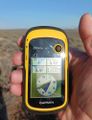
| Fri 28 Apr 2023 in 43,-119: 43.3809107, -119.6136029 geohashing.info google osm bing/os kml crox |
Location
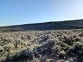
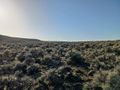
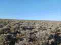
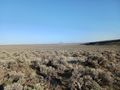
In the sagebrush plains east of US 395.
Participants
Expedition
After 2023-04-28 44 -121 and stops in Sister and Bend, I headed out into the sparsely inhabited southeast quarter of Oregon on US Highway 20. After 120 miles or so, there's the junction with US 395, and I turned south there and drove down to the same turnoff I used for Expedition 207 -- not at the hashpoint itself, but the place I stopped before the hashpoint to go running. That time, I ran west up Squaw Butte Road, a well maintained gravel lane. This time, I got out the bicycle and headed east up Big Stick Road, a pair of ruts that clearly hadn't had any human traffic since at least the last time it rained.
Two and a half miles on the bicycle got me within 1.13 miles of the hashpoint, which was somewhere out there on a plain of sagebrush. Checking the time until sundown and the batteries on my equipment, I headed out. Walking across a sagebrush plain isn't really much harder than walking down a sidewalk, so aside from the curious feeling of vulnerability a city person feels when they can see for a few miles in all directions and yet they are the only person present, it was really little more than a pleasant stroll. Naturally getting to the third hashpoint in one day felt pretty good.
Back on my bicycle, I came up from the downwind side and startled an antelope grazing by the road. I mean, I was fairly startled too, but the antelope seemed to be well and truly freaked out as it disappeared towards the horizon. Admittedly, antelopes probably didn't have a lot of bicycles in their evolutionary environment.
After backtracking to US 20, I continued east to the remote town of Burns, arriving just as dusk fell. After two hashpoints in the forest and one in the desert, I was as filthy as a child after a long summer day of playing outdoors. And perhaps as happy.
Photos
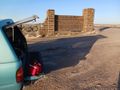
The starting point on US 395.
Through the gate...
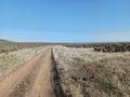
...and into the desert.
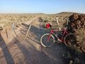
Leaving the bicycle for the last stretch.
There!

Triple-hash satisfaction.
Southwest from the hashpoint.
Northwest...
Northeast, back towards the bike...
Southeast.
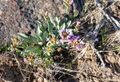
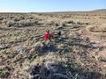
A pretty little flower that lives at the hashpoint.
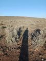
Casting a long shadow.


Achievements
Michael5000 earned the Graticule Unlocked Achievement
|
Michael5000 earned the Multihash Achievement
|
Michael5000 achieved level 7 of the Minesweeper Geohash achievement
|
Michael5000 achieved level 6 of the Minesweeper Geohash achievement
|
Michael5000 achieved level 6 of the Minesweeper Geohash achievement
|
Michael5000 achieved level 5 of the Minesweeper Geohash achievement
|