Difference between revisions of "2023-04-28 44 -122"
Michael5000 (talk | contribs) (→Photos) |
Michael5000 (talk | contribs) (→Achievements) |
||
| Line 53: | Line 53: | ||
}} | }} | ||
| − | |||
| − | |||
| − | |||
| − | |||
| − | |||
| − | |||
| − | |||
| − | |||
| − | |||
| − | |||
| − | |||
| − | |||
[[Category:Expeditions]] | [[Category:Expeditions]] | ||
| − | |||
[[Category:Expeditions with photos]] | [[Category:Expeditions with photos]] | ||
| − | |||
| − | |||
| − | |||
| − | |||
| − | |||
[[Category:Coordinates reached]] | [[Category:Coordinates reached]] | ||
| − | |||
| − | |||
| − | |||
| − | |||
| − | |||
| − | |||
| − | |||
| − | |||
| − | |||
| − | |||
| − | |||
| − | |||
| − | |||
| − | |||
| − | |||
| − | |||
| − | |||
| − | |||
Revision as of 00:23, 1 May 2023
| Fri 28 Apr 2023 in 44,-122: 44.3809107, -122.6136029 geohashing.info google osm bing/os kml crox |
Location
In the woods near Sweet Home, Oregon.
Participants
Expedition
It seemed like spring would never arrive, so I took some time off work. On Thursday, I looked at the hashpoints and they weren't interesting, so I stayed home and worked in the garden and did the laundry. But on Friday, I looked at the hashpoints and they were very interesting.
I drove down I-5 as far as Albany, then passed through Lebanon and Sweet Home and turned south of the highway into the the woods. A forest road got within a quarter mile of the hashpoint, but everything was quite a bit steeper than I had expected and it was a bit of a cliff at the road's edge at that point. There was a level opening into the forest a short way up the road, but that way was quickly blocked off by brambles. Hmph.
I drove a little further down the road and found an old gate, which seemed like it might have potential. It had been quite some time since the road behind it had seen any use, but it still offered an easy path through the forest. Well, relatively easy. It was very steep path, and it got progressively narrower and narrower, but it kept curving nicely towards the hashpoint until about 400 feet out, where it abruptly ended in an another impassable bramble patch.
Fortunately, I had had the foresight to wear my designated forest geohashing trousers (as purchased during Expedition 221), so I was able to crash through the underbrush in a big loop around the briars, scramble over a few downed logs, and finally fight my way to the hashpoint, a little winded but basically intact. I lingered for a while to catch my breath.
It was much easier going back down. I got to the truck and, after pulling off the road for a while to let an enormous crane pass on the way uphill, got out to the highway and continued one graticule east to 2023-04-28 44 -121.
Photos
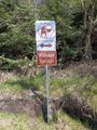
The access road was called Whiskey Springs Road. No actual whiskey was in evidence.
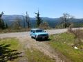
The staging point.
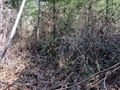
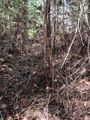
Impassible brambles.
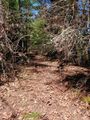
Starting up the road.
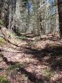
The road gets rougher...
The road is no longer visible to the untrained eye...
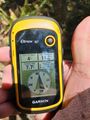
Success.
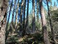
Looking upslope from the hashpoint.

Michael5000 in the woods.


Achievements
Michael5000 earned the Multihash Achievement
|