Difference between revisions of "2023-05-12 45 -122"
Michael5000 (talk | contribs) (→Location) |
m (Location) |
||
| (One intermediate revision by one other user not shown) | |||
| Line 16: | Line 16: | ||
== Participants == | == Participants == | ||
| − | + | *[[User:Michael5000|Michael5000]] | |
| − | |||
| − | == | + | == Expedition == |
| − | + | It was a pretty long trip for a local hashpoint, and I knew that it wasn't a sure thing, but it was a rare chance to try for that little piece of Cowlitz County that sticks down into the Portland graticule. And who could resist trying for that? Literally everyone else on the planet except me, that's who. | |
| − | + | I waited for a while after work for the bridges to settle down, and then took the long trip up across the still-congested I-5 bridge and into Washington State -- a dull drive mitigated by a pretty evening and a good audiobook -- then headed east on Washington 503, a nice and new-to-me but fairly typical Northwestern road. Finally I got to my turnoff, pulled onto Woodland Park Road, and then: '''NOPE!!''' The road looks open up at the highway, but once you get down where the Google truck can't see it, there's a gate. | |
| − | |||
| − | + | So that pretty much took my entire Friday night, and I thought that geohashing was a very stupid hobby, and I will probably never do it ever again, at any rate until Sunday. 2023-05-14 45 -122 looks like a sure thing! | |
| − | |||
== Photos == | == Photos == | ||
| − | |||
| − | |||
| − | |||
<gallery perrow="5"> | <gallery perrow="5"> | ||
| + | File:2023-05-12 45 -122 1.jpg|Beautiful evening. | ||
| + | File:2023-05-12 45 -122 2.jpg|Aw, dang. | ||
| + | File:2023-05-12 45 -122 3.jpg|Dang. | ||
</gallery> | </gallery> | ||
== Achievements == | == Achievements == | ||
{{#vardefine:ribbonwidth|100%}} | {{#vardefine:ribbonwidth|100%}} | ||
| − | |||
__NOTOC__ | __NOTOC__ | ||
| − | |||
| − | |||
| − | |||
| − | |||
| − | |||
| − | |||
| − | |||
| − | |||
| − | |||
| − | |||
| − | |||
| − | |||
| − | |||
[[Category:Expeditions]] | [[Category:Expeditions]] | ||
| − | |||
[[Category:Expeditions with photos]] | [[Category:Expeditions with photos]] | ||
| − | |||
| − | |||
| − | |||
| − | |||
| − | |||
| − | |||
| − | |||
| − | |||
| − | |||
[[Category:Coordinates not reached]] | [[Category:Coordinates not reached]] | ||
| − | |||
| − | |||
| − | |||
| − | |||
| − | |||
[[Category:Not reached - No public access]] | [[Category:Not reached - No public access]] | ||
| − | + | {{location|US|WA|CW}} | |
| − | |||
| − | |||
| − | |||
| − | |||
| − | |||
| − | |||
| − | |||
Latest revision as of 16:42, 13 May 2023
| Fri 12 May 2023 in 45,-122: 45.9914241, -122.4763167 geohashing.info google osm bing/os kml crox |
Location
On Woodland Park Road, off of Washington Highway 503.
Participants
Expedition
It was a pretty long trip for a local hashpoint, and I knew that it wasn't a sure thing, but it was a rare chance to try for that little piece of Cowlitz County that sticks down into the Portland graticule. And who could resist trying for that? Literally everyone else on the planet except me, that's who.
I waited for a while after work for the bridges to settle down, and then took the long trip up across the still-congested I-5 bridge and into Washington State -- a dull drive mitigated by a pretty evening and a good audiobook -- then headed east on Washington 503, a nice and new-to-me but fairly typical Northwestern road. Finally I got to my turnoff, pulled onto Woodland Park Road, and then: NOPE!! The road looks open up at the highway, but once you get down where the Google truck can't see it, there's a gate.
So that pretty much took my entire Friday night, and I thought that geohashing was a very stupid hobby, and I will probably never do it ever again, at any rate until Sunday. 2023-05-14 45 -122 looks like a sure thing!
Photos
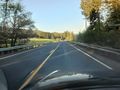
Beautiful evening.
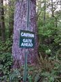
Aw, dang.
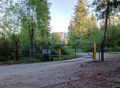
Dang.


