2023-07-09 45 -121
| Sun 9 Jul 2023 in 45,-121: 45.7396245, -121.8928632 geohashing.info google osm bing/os kml crox |
Location
In the forest north of Stevenson, Washington.
Participants
- Geohasher X
Plans
Expedition
Michael5000
So I took a long drive, and went for a run in Madras, Oregon, and then drove up to The Dalles and had lunch. Then, since there's a stretch of Washington 14 that's closed due to a recent fire, I crossed the Columbia on the Bridge of the Gods at Cascade Locks, and then backtracked east a few miles to Stevenson.
From Stevenson, I drove north to Skaar Road, then felt good about my new vehicle as the road degraded to a rough one-lane gravel track. About a kilometer from the hashpoint, I found a good place to park, and then got out my bicycle to make it the rest of the way to the hashpoint, because that's how I roll.
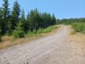
But, that didn't work. The road kept gaining elevation, not quite as steep as a staircase, but -- wow! -- close. After a while, I just abandoned my bike and just kept trudging upwards.
The hashpoint was down a steep decline from the road. As I approached it, and tried to figure out the best way to make my way down to it, I noticed something unusual: there was something there. Which was weird, because when you try to explain geohashing to a civilian, then always ask "what will you find at the hashpoint? And the answer, of course, is "Nothing. Duh." But there was a thing at this hashpoint!
A geohasher had been here before me! And, wow -- I think it's been more than 10 years since I've found evidence of a previous geohasher at a hashpoint. I suspect Thomcat. Or maybe Hamblingreen. Or perhaps Fippe on Summer holiday, keeping me humble. Or Frogman, stealthily, but he was in Toronto just yesterday, so that seems unlikely.
So that was awesome!
Tracklog
Photos
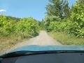
Skarr Road gets rugged

Trudging uphill
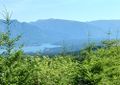
View back towards Cascade Locks and Bridge of the Gods
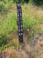
CG Roads must be Columbia Gorge roads
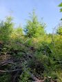
The hashpoint is over on the left
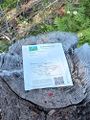
OMG! OMG!

OMG!
Looking back towards the road from the hashpoint
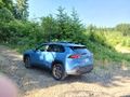
Always good to get back to the expedition vehicle


