Difference between revisions of "2023-07-27 51 -1"
| Line 3: | Line 3: | ||
|lon=-1 | |lon=-1 | ||
|date=2023-07-27 | |date=2023-07-27 | ||
| − | }} | + | }} __NOTOC__ |
| − | __NOTOC__ | ||
== Location == | == Location == | ||
Northern boundary hedge of West Witney Primary School, Witney. | Northern boundary hedge of West Witney Primary School, Witney. | ||
| Line 14: | Line 13: | ||
== Expedition == | == Expedition == | ||
| − | + | I wasn't supposed to be here. I was supposed to be on the Isle of Man with my partner, celebrating our <code>0x10</code>th anniversary. But this week's been a week of disasters: my partner lost her job, our plane to the Isle of Man got cancelled, and then I got sick (most-likely, I got to catch airport germs from people I got to sit next to on an aircraft which was then cancelled before it had a chance to take off). So mostly this week I've been sat at home playing video games. | |
| + | |||
| + | But the dog needed a walk, and my partner needed to go to the supermarket, so I had her drop me and the geopooch off in West Witney to find the hashpoint and then walk to meet them after she'd collected the shopping. I couldn't find my GPSr, so I used my phone, and it was reporting low accuracy until I rebooted it, by which time I'd walked past the hashpoint and had to double-back, much to the doggo's confusion. | ||
| + | |||
| + | I reached the hashpoint at 14:16 (and probably a few points before than, owing to my navigation failure). I needed to stand very close to the fence to get within the circle of uncertainty, but at least I didn't have to reach through and into the school grounds. | ||
== Tracklog == | == Tracklog == | ||
| − | + | My smartwatch kept a tracklog: | |
| + | {{ Tracklog | Activity_11654052401.gpx }} | ||
| + | * Download: [[:File:Activity_11654052401.gpx]] | ||
== Photos == | == Photos == | ||
| − | |||
| − | |||
| − | |||
<gallery perrow='5'> | <gallery perrow='5'> | ||
| + | Image:Screenshot 20230727 141637 Geohash Droid.png | Proof (from the app) | ||
| + | Image:20230727 141654.jpg | Looking East from the hashpoint | ||
| + | Image:20230727 141651.jpg | Looking West from the hashpoint | ||
| + | Image:20230727 141710.jpg | A pair of silly grins | ||
</gallery> | </gallery> | ||
| − | |||
| − | |||
| − | |||
| − | |||
| − | |||
| − | |||
| − | |||
| − | |||
| − | |||
| − | |||
| − | |||
| − | |||
| − | |||
| − | |||
| − | |||
| − | |||
| − | |||
| − | |||
[[Category:Expeditions]] | [[Category:Expeditions]] | ||
| − | |||
[[Category:Expeditions with photos]] | [[Category:Expeditions with photos]] | ||
| − | |||
| − | |||
| − | |||
| − | |||
| − | |||
[[Category:Coordinates reached]] | [[Category:Coordinates reached]] | ||
| − | |||
| − | |||
| − | |||
| − | |||
| − | |||
| − | |||
| − | |||
| − | |||
| − | |||
| − | |||
| − | |||
| − | |||
| − | |||
| − | |||
| − | |||
| − | |||
| − | |||
| − | |||
Revision as of 14:09, 27 July 2023
| Thu 27 Jul 2023 in 51,-1: 51.7874680, -1.5066508 geohashing.info google osm bing/os kml crox |
Location
Northern boundary hedge of West Witney Primary School, Witney.
Participants
Expedition
I wasn't supposed to be here. I was supposed to be on the Isle of Man with my partner, celebrating our 0x10th anniversary. But this week's been a week of disasters: my partner lost her job, our plane to the Isle of Man got cancelled, and then I got sick (most-likely, I got to catch airport germs from people I got to sit next to on an aircraft which was then cancelled before it had a chance to take off). So mostly this week I've been sat at home playing video games.
But the dog needed a walk, and my partner needed to go to the supermarket, so I had her drop me and the geopooch off in West Witney to find the hashpoint and then walk to meet them after she'd collected the shopping. I couldn't find my GPSr, so I used my phone, and it was reporting low accuracy until I rebooted it, by which time I'd walked past the hashpoint and had to double-back, much to the doggo's confusion.
I reached the hashpoint at 14:16 (and probably a few points before than, owing to my navigation failure). I needed to stand very close to the fence to get within the circle of uncertainty, but at least I didn't have to reach through and into the school grounds.
Tracklog
My smartwatch kept a tracklog:
- Download: File:Activity_11654052401.gpx
Photos

Proof (from the app)
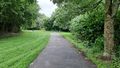
Looking East from the hashpoint
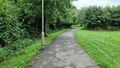
Looking West from the hashpoint

A pair of silly grins


