Difference between revisions of "2023-09-03 45 -122"
From Geohashing
m (Adjust name) |
Michael5000 (talk | contribs) (→Photos) |
||
| Line 22: | Line 22: | ||
== Photos == | == Photos == | ||
| − | |||
| − | |||
| − | |||
| − | |||
| − | |||
<gallery perrow="5"> | <gallery perrow="5"> | ||
| + | File:2023-09-03 45 -122 a.jpg|Looking down the street towards the hashpoint... | ||
| + | File:2023-09-03 45 -122 b.jpg|...which is at the base of this tree. | ||
| + | File:2023-09-03 45 -122 c.jpg|Here. | ||
</gallery> | </gallery> | ||
Revision as of 17:17, 4 September 2023
| Sun 3 Sep 2023 in 45,-122: 45.4709571, -122.8946800 geohashing.info google osm bing/os kml crox |
Location
Off 209th Avenue west of Aloha.
Participants
Expedition
I drove out to the western edge of the city, parked on a side street, and walked two blocks to the hashpoint. So that was pretty good. Then I continued out to Newberg, in Yamhill County, where I sprained my ankle. Successful geohashing, but not a great expedition as a whole.
Jim was out running errands and went by the hashpoint and ended up 18 feet from it....
Photos
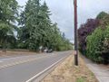
Looking down the street towards the hashpoint...
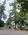
...which is at the base of this tree.
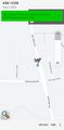
Here.


