Difference between revisions of "2023-10-29 -34 138"
(create new expedition page) |
(writing the page) |
||
| Line 14: | Line 14: | ||
== Location == | == Location == | ||
<!-- where you've surveyed the hash to be --> | <!-- where you've surveyed the hash to be --> | ||
| + | In front of the [[wikipedia:Adelaide Oval|Adelaide Oval]] south gate | ||
== Participants == | == Participants == | ||
<!-- who attended: If you link to your wiki user name in this section, your expedition will be picked up by the various statistics generated for geohashing. You may use three tildes ~ as a shortcut to automatically insert the user signature of the account you are editing with. | <!-- who attended: If you link to your wiki user name in this section, your expedition will be picked up by the various statistics generated for geohashing. You may use three tildes ~ as a shortcut to automatically insert the user signature of the account you are editing with. | ||
--> | --> | ||
| + | [[User:XXOs|XXOs]] ([[User talk:XXOs|talk]]) | ||
== Plans == | == Plans == | ||
<!-- what were the original plans --> | <!-- what were the original plans --> | ||
| + | After finding out about this hash on Saturday and subsequently putting the following message in the [[Discord]]: | ||
| + | |||
| + | [[File:2023-10-29 -34 138 discord.png|x100px|alt=A screenshot of a Discord message from XXOs saying 'tomorrow's is literally just in front of adelaide oval holy shit']] | ||
| + | |||
| + | I planned to take a bus into the city after lunch. | ||
| + | |||
| + | I also realised that the geocache [https://coord.info/GC2CJWA GC2CJWA (Anatidaephobia)] was nearby and that I could potentially get a [[Hash collision achievement]]. | ||
== Expedition == | == Expedition == | ||
<!-- how it all turned out. your narrative goes here. --> | <!-- how it all turned out. your narrative goes here. --> | ||
| + | While it would have been convenient for me to take a bus more or less directly to the hash (given that it was right outside Adelaide Oval), I instead opted for a bus to take me to a [[GeoSquishy]] vendor first because there was one [https://www.mapdevelopers.com/distance_from_to.php?&from=144%20North%20Terrace%2C%20Adelaide%20SA%205000&to=War%20Memorial%20Dr%2C%20North%20Adelaide%20SA%205006 within 1km of the hash]. | ||
| + | |||
| + | After obtaining my GeoSquishy (and a donut because why not), I walked from the OTR across the Torrens via a bridge with an unnecessarily long name (the Riverbank Precinct Pedestrian Bridge). I then proceeded to spend an embarrassingly long time finding the 1/5 difficulty, 1/5 terrain geocache that I'd identified in planning. Thankfully I found it eventually, and to be honest it was quite a fun find. | ||
| + | |||
| + | The cache isn't the point of this expedition, though, and so the next thing to do was to actually reach the hash point. That was beyond easy, given that it was basically just across the road from the cache and in very publicly accessible land. By this point most of my GeoSquishy was either melted or had been drank, so I finished it off there. I took the relevant [[proof]] images, including a few of my [[User:XXOs/Therm|new hashscot]], and then took a bus back home. | ||
== Tracklog == | == Tracklog == | ||
<!-- if your GPS device keeps a log, you may use Template:Tracklog, post a link here, or both --> | <!-- if your GPS device keeps a log, you may use Template:Tracklog, post a link here, or both --> | ||
| + | Given that I was in the city for most of this hash, some of the tracklog is a bit off. | ||
| + | {{tracklog | 2023-10-29 -34 138 XXOs.gpx}} | ||
== Photos == | == Photos == | ||
| Line 33: | Line 49: | ||
--> | --> | ||
<gallery perrow="5"> | <gallery perrow="5"> | ||
| + | Image:2023-10-29 -34 138 geosquishy vendor.jpg | The [[GeoSquishy]] vendor, OTR North Terrace | ||
| + | Image:2023-10-29 -34 138 geosquishy obtained.jpg | I went with Vanilla Coke. | ||
| + | Image:2023-10-29 -34 138 adelaide oval.jpg | honestly i'm surprised at how good this picture looks | ||
| + | Image:2023-10-29 -34 138 geocache.jpg | [http://wiki.geocaching.com.au/wiki/Logging_a_cache#Online_logging TFTC]! | ||
| + | Image:2023-10-29 -34 138 line of sight.jpg | ...and yes, it's visible from the hash. | ||
| + | Image:2023-10-29 -34 138 google maps.png | Obligatory Google Maps proof <small>(i swear i'm going to get a non-phone gps device eventually)</small> | ||
| + | Image:2023-10-29 -34 138 watch.jpg | watch this! *laughter sfx* | ||
| + | Image:2023-10-29 -34 138 hashscot 1.jpg | My hashscot, [[User:XXOs/Therm|Therm]]! | ||
| + | Image:2023-10-29 -34 138 hashscot 2.jpg | sip | ||
| + | Image:2023-10-29 -34 138 tshirt.jpg | Oh right, I was wearing an [https://xkcd.com/552/ xkcd t-shirt]. | ||
</gallery> | </gallery> | ||
== Achievements == | == Achievements == | ||
| + | '''[[GeoSquishy]] Stars:''' +5 | ||
{{#vardefine:ribbonwidth|100%}} | {{#vardefine:ribbonwidth|100%}} | ||
| − | + | {{Hash collision | |
| + | | latitude = -34 | ||
| + | | longitude = 138 | ||
| + | | date = 2023-10-29 | ||
| + | | name = XXOs | ||
| + | | id = GC2CJWA | ||
| + | | image = 2023-10-29 -34 138 geocache.jpg | ||
| + | }} | ||
__NOTOC__ | __NOTOC__ | ||
| − | <!-- =============== USEFUL CATEGORIES FOLLOW ================ | + | <!-- =============== USEFUL CATEGORIES FOLLOW ================ --> |
| − | |||
| − | |||
<!-- ==REQUEST FOR TWITTER BOT== Please leave either the New report or the Expedition planning category in as long as you work on it. This helps the twitter bot a lot with announcing the right outcome at the right moment. --> | <!-- ==REQUEST FOR TWITTER BOT== Please leave either the New report or the Expedition planning category in as long as you work on it. This helps the twitter bot a lot with announcing the right outcome at the right moment. --> | ||
| − | |||
| − | |||
| − | |||
| − | |||
| − | |||
| − | |||
| − | |||
| − | |||
[[Category:Expeditions]] | [[Category:Expeditions]] | ||
| − | |||
[[Category:Expeditions with photos]] | [[Category:Expeditions with photos]] | ||
| − | |||
| − | |||
| − | |||
| − | |||
| − | |||
[[Category:Coordinates reached]] | [[Category:Coordinates reached]] | ||
| − | |||
| − | |||
| − | |||
| − | |||
| − | |||
| − | |||
| − | |||
| − | |||
| − | |||
| − | |||
| − | |||
| − | |||
| − | |||
| − | |||
| − | |||
| − | |||
| − | |||
| − | |||
Revision as of 06:34, 29 October 2023
| Sun 29 Oct 2023 in -34,138: -34.9171734, 138.5969208 geohashing.info google osm bing/os kml crox |
Location
In front of the Adelaide Oval south gate
Participants
Plans
After finding out about this hash on Saturday and subsequently putting the following message in the Discord:

I planned to take a bus into the city after lunch.
I also realised that the geocache GC2CJWA (Anatidaephobia) was nearby and that I could potentially get a Hash collision achievement.
Expedition
While it would have been convenient for me to take a bus more or less directly to the hash (given that it was right outside Adelaide Oval), I instead opted for a bus to take me to a GeoSquishy vendor first because there was one within 1km of the hash.
After obtaining my GeoSquishy (and a donut because why not), I walked from the OTR across the Torrens via a bridge with an unnecessarily long name (the Riverbank Precinct Pedestrian Bridge). I then proceeded to spend an embarrassingly long time finding the 1/5 difficulty, 1/5 terrain geocache that I'd identified in planning. Thankfully I found it eventually, and to be honest it was quite a fun find.
The cache isn't the point of this expedition, though, and so the next thing to do was to actually reach the hash point. That was beyond easy, given that it was basically just across the road from the cache and in very publicly accessible land. By this point most of my GeoSquishy was either melted or had been drank, so I finished it off there. I took the relevant proof images, including a few of my new hashscot, and then took a bus back home.
Tracklog
Given that I was in the city for most of this hash, some of the tracklog is a bit off.
Photos

The GeoSquishy vendor, OTR North Terrace
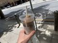
I went with Vanilla Coke.
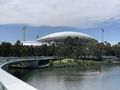
honestly i'm surprised at how good this picture looks
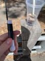
TFTC!
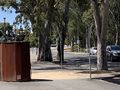
...and yes, it's visible from the hash.
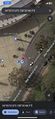
Obligatory Google Maps proof (i swear i'm going to get a non-phone gps device eventually)
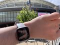
watch this! *laughter sfx*
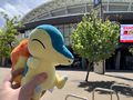
My hashscot, Therm!
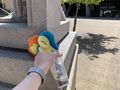
sip
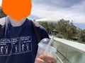
Oh right, I was wearing an xkcd t-shirt.


Achievements
GeoSquishy Stars: +5
XXOs earned the Hash collision achievement
|