Difference between revisions of "2024-02-10 47 -122"
([live picture]Pre-func Spud [https://openstreetmap.org/?mlat=47.67831300&mlon=-122.32700900&zoom=16 @47.6783,-122.3270]) |
|||
| (7 intermediate revisions by 2 users not shown) | |||
| Line 21: | Line 21: | ||
== Expedition == | == Expedition == | ||
<!-- how it all turned out. your narrative goes here. --> | <!-- how it all turned out. your narrative goes here. --> | ||
| + | A sunny morning turned to light clouds by early afternoon. Coyotebush debated between routes suggested by Google Maps before selecting a simpler route from Garmin heading directly north from Green Lake. Not too much traffic today, but the segments without bike lanes might have been less pleasant at peak commute times. Influenced by the conservative time estimates from Google Maps, coyotebush arrived 10 minutes early at the semi-private drive, then retreated to the public road to watch for Thomcat. | ||
| − | == | + | *Looks promising but don't want to disturb the neighbors more than necessary for the meetup -- [[User:Coyotebush|Coyotebush]] ([[User talk:Coyotebush|talk]]) [https://openstreetmap.org/?mlat=47.72153399&mlon=-122.33583372&zoom=16 @47.7215,-122.3358] 15:50, 10 February 2024 (PST) |
| − | + | ||
| + | Thomcat drove to Spud first, along with other errands (remounting closet doors, etc.). Hashdog Daisy went with, and I arrived by car at 3:58pm. | ||
| + | |||
| + | Together they proceeded towards the lake. At the point they found waste bins belonging to one of the houses. They admired an artificial stream in the well-manicured yard to the west. Then they returned to the road and parted ways. | ||
| + | |||
| + | Coyotebush returned home by a different route, up and over a large hill comprising the Maple Leaf neighborhood. | ||
| + | |||
| + | Thomcat returned to his domicile to consider why his Android photos are now uploaded sideways... :/ | ||
== Photos == | == Photos == | ||
| Line 32: | Line 40: | ||
Image:2024-02-10_47_-122_thomcat_1707606840262.jpg|Pre-func Spud [https://openstreetmap.org/?mlat=47.67831300&mlon=-122.32700900&zoom=16 @47.6783,-122.3270] | Image:2024-02-10_47_-122_thomcat_1707606840262.jpg|Pre-func Spud [https://openstreetmap.org/?mlat=47.67831300&mlon=-122.32700900&zoom=16 @47.6783,-122.3270] | ||
| + | |||
| + | Image:2024-02-10_47_-122_thomcat_1707609910568.jpg|Sideways alley :( [https://openstreetmap.org/?mlat=47.72151800&mlon=-122.33582597&zoom=16 @47.7215,-122.3358] | ||
| + | |||
| + | Image:2024-02-10_47_-122_coyotebush_1707612020480.jpg|"not technically no trespassing" [https://openstreetmap.org/?mlat=47.72143889&mlon=-122.33613333&zoom=16 @47.7214,-122.3361] | ||
| + | |||
| + | Image:2024-02-10_47_-122_thomcat_1707609641771.jpg|Hasher [https://openstreetmap.org/?mlat=47.72103100&mlon=-122.33539600&zoom=16 @47.7210,-122.3354] | ||
| + | |||
| + | Image:2024-02-10_47_-122_coyotebush_1707612059619.jpg|Meetup - hashers and companions [https://openstreetmap.org/?mlat=47.72091389&mlon=-122.33536667&zoom=16 @47.7209,-122.3354] | ||
| + | |||
| + | Image:2024-02-10_47_-122_coyotebush_1707612122555.jpg|Map | ||
</gallery> | </gallery> | ||
| Line 38: | Line 56: | ||
<!-- Add any achievement ribbons you earned below, or remove this section --> | <!-- Add any achievement ribbons you earned below, or remove this section --> | ||
| − | |||
| − | |||
| − | |||
| − | |||
| − | + | {{bicycle geohash | |
| + | |||
| + | | latitude = 47 | ||
| + | | longitude = -122 | ||
| + | | date = 2024-02-10 | ||
| + | | name = coyotebush | ||
| + | | bothways = true | ||
| − | + | }} | |
| − | |||
| − | |||
| − | |||
| − | + | {{XKCD Centurion | |
| − | + | | count = 5 | |
| − | + | | name = coyotebush | |
| − | |||
| − | |||
| − | |||
| − | |||
| − | |||
| − | |||
| − | |||
| − | |||
| + | }} | ||
| + | {{XKCD Centurion | ||
| − | + | | count = 27 | |
| − | + | | name = thomcat | |
| − | |||
| − | |||
| − | |||
| − | |||
| − | |||
| − | |||
| − | + | }} | |
| − | |||
| − | |||
| − | |||
| − | |||
| − | + | __NOTOC__ | |
| + | [[Category:Expeditions]] | ||
| + | [[Category:Expeditions with photos]] | ||
| + | [[Category:Coordinates reached]] | ||
| + | {{location|US|WA|KN}} | ||
Latest revision as of 20:09, 11 February 2024
| Sat 10 Feb 2024 in Seattle: 47.7210372, -122.3353634 geohashing.info google osm bing/os kml crox |
Location
A semi-private drive next to Haller Lake.
Participants
Plans
Bike there. 4pm per convention, or another time for a meetup. Coyotebush (talk) 16:53, 10 February 2024 (UTC)
Driving due to other commitments. 4pm perfect. --Thomcat (talk)
Expedition
A sunny morning turned to light clouds by early afternoon. Coyotebush debated between routes suggested by Google Maps before selecting a simpler route from Garmin heading directly north from Green Lake. Not too much traffic today, but the segments without bike lanes might have been less pleasant at peak commute times. Influenced by the conservative time estimates from Google Maps, coyotebush arrived 10 minutes early at the semi-private drive, then retreated to the public road to watch for Thomcat.
- Looks promising but don't want to disturb the neighbors more than necessary for the meetup -- Coyotebush (talk) @47.7215,-122.3358 15:50, 10 February 2024 (PST)
Thomcat drove to Spud first, along with other errands (remounting closet doors, etc.). Hashdog Daisy went with, and I arrived by car at 3:58pm.
Together they proceeded towards the lake. At the point they found waste bins belonging to one of the houses. They admired an artificial stream in the well-manicured yard to the west. Then they returned to the road and parted ways.
Coyotebush returned home by a different route, up and over a large hill comprising the Maple Leaf neighborhood.
Thomcat returned to his domicile to consider why his Android photos are now uploaded sideways... :/
Photos
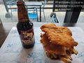
Pre-func Spud @47.6783,-122.3270
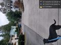
Sideways alley :( @47.7215,-122.3358
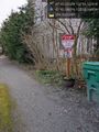
"not technically no trespassing" @47.7214,-122.3361
Hasher @47.7210,-122.3354
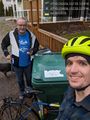
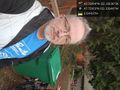
Meetup - hashers and companions @47.7209,-122.3354
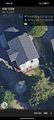
Map


Achievements
coyotebush earned the Bicycle geohash achievement
|
coyotebush earned the xkcd Nullaturion achievement
|
thomcat earned the xkcd Viginturion achievement
|