Difference between revisions of "2024-02-13 37 -122"
From Geohashing
(→Tracklog) |
m (Location) |
||
| (4 intermediate revisions by 2 users not shown) | |||
| Line 34: | Line 34: | ||
--> | --> | ||
<gallery perrow="5"> | <gallery perrow="5"> | ||
| + | Image:2024-02-13 37 -122 across1.jpg | First sighting of the point from the road | ||
| + | Image:2024-02-13 37 -122 across.jpg | As close to the point as possible on the trail | ||
| + | Image:2024-02-13 37 -122 selfie.jpg | Made it! | ||
| + | Image:2024-02-13 37 -122 upriver.jpg | View from the point upriver | ||
| + | Image:2024-02-13 37 -122 downriver.jpg | View from the point downriver | ||
| + | Image:2024-02-13 37 -122 proof.png | Proof | ||
</gallery> | </gallery> | ||
| Line 39: | Line 45: | ||
{{#vardefine:ribbonwidth|100%}} | {{#vardefine:ribbonwidth|100%}} | ||
<!-- Add any achievement ribbons you earned below, or remove this section --> | <!-- Add any achievement ribbons you earned below, or remove this section --> | ||
| + | {{Land geohash | ||
| + | | latitude = 37 | ||
| + | | longitude = -122 | ||
| + | | date = 2024-02-13 | ||
| + | | name = calymsis | ||
| + | }} | ||
| + | {{Two to the N achievement | ||
| + | | count = 2 | ||
| + | | latitude = 37 | ||
| + | | longitude = -122 | ||
| + | | date = 2024-02-13 | ||
| + | | reached = true | ||
| + | | name = calymsis | ||
| + | }} | ||
| + | {{Public transport geohash | ||
| + | | latitude = 37 | ||
| + | | longitude = -122 | ||
| + | | date = 2024-02-13 | ||
| + | | busline = BART and the 200 bus | ||
| + | | name = calymsis}} | ||
__NOTOC__ | __NOTOC__ | ||
| − | |||
| − | |||
| − | |||
| − | |||
| − | |||
| − | |||
| − | |||
| − | |||
| − | |||
| − | |||
| − | |||
| − | |||
| − | |||
| − | |||
[[Category:Expeditions]] | [[Category:Expeditions]] | ||
| − | + | [[Category:Expeditions with photos]] | |
| − | [[Category:Expeditions with photos]] | ||
| − | |||
| − | |||
| − | |||
| − | |||
| − | |||
[[Category:Coordinates reached]] | [[Category:Coordinates reached]] | ||
| − | + | {{location|US|CA|AA}} | |
| − | |||
| − | |||
| − | |||
| − | |||
| − | |||
| − | |||
| − | |||
| − | |||
| − | |||
| − | |||
| − | |||
| − | |||
| − | |||
| − | |||
| − | |||
| − | |||
| − | |||
Latest revision as of 09:42, 14 February 2024
| Tue 13 Feb 2024 in 37,-122: 37.5796130, -122.0271225 geohashing.info google osm bing/os kml crox |
Location
Just off the Alameda Creek Trail in Fremont.
Participants
Plans
I'll take BART to Union City and then the 99 bus to just south of the point, arriving around 2:30 ideally.
Expedition
Pretty uneventful - probably the least time I've spent getting to a hash so far (about 1:15). I did manage to catch an earlier BART so I arrived close to 2 rather than around 2:30. The point was right at the base of the rocky embankment so it was easy to walk along the dirt at the bottom to find it. I ate lunch just above the point in case someone else showed up and then headed home.
Photos
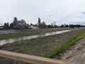
First sighting of the point from the road
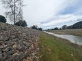
As close to the point as possible on the trail
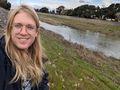
Made it!
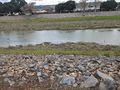
View from the point upriver
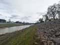
View from the point downriver

Proof


Achievements
calymsis earned the Land geohash achievement
|

calymsis earned the Two to the N achievement
by reaching 22 hashpoints on 2024-02-13 37 -122 and is promoted to Level 2 (Coordinates reached).
calymsis earned the Public transport geohash achievement
|