Difference between revisions of "2024-03-23 55 -4"
m (Adding photos) |
m |
||
| (3 intermediate revisions by the same user not shown) | |||
| Line 1: | Line 1: | ||
{{meetup graticule|date=2024-03-23|lat=55|lon=-4}} | {{meetup graticule|date=2024-03-23|lat=55|lon=-4}} | ||
{{location|GB|SCT|WDU}} | {{location|GB|SCT|WDU}} | ||
| + | {{user categories|user=KerrMcF|car=47.8|foot=3.8}} | ||
== Location == | == Location == | ||
| Line 18: | Line 19: | ||
So, at around 4:20pm, my dad and I set off in the direction of the point. We had heard gunshots earlier in the 40 minutes before this, which was concerning, but it was now silent. We planned that if we came across anything that looked like it indicated a shooting range, we would turn back. We didn't get overly far until that happened, 10 minutes of walking up a farm road and we reached some signs that looked a little dodgy. We probably would have been fine to continue, the gunfire had stopped and the signs maybe didn't indicate that the area was a shooting range, but it's better to be safe than sorry in any case. We drove back home shortly afterwards. | So, at around 4:20pm, my dad and I set off in the direction of the point. We had heard gunshots earlier in the 40 minutes before this, which was concerning, but it was now silent. We planned that if we came across anything that looked like it indicated a shooting range, we would turn back. We didn't get overly far until that happened, 10 minutes of walking up a farm road and we reached some signs that looked a little dodgy. We probably would have been fine to continue, the gunfire had stopped and the signs maybe didn't indicate that the area was a shooting range, but it's better to be safe than sorry in any case. We drove back home shortly afterwards. | ||
| + | |||
| + | ''Update 2024-03-24:'' | ||
| + | |||
| + | We were visiting my grandad as a family today, and decided we would go to the cemetery with him to see if we could find my dad’s friend’s grave. We were able to do so this time, so that part of the expedition was now a success! | ||
== Photos == | == Photos == | ||
| Line 38: | Line 43: | ||
|- | |- | ||
| width="100px" | [[File:Arrow7.png|12px]] [[2024-03-22 56 -4|Previous]] | | width="100px" | [[File:Arrow7.png|12px]] [[2024-03-22 56 -4|Previous]] | ||
| − | | width=" | + | | width="200px" | [[User:KerrMcF|KerrMcF]]'s expeditions |
| − | | width="100px" | No Next Yet | + | | width="100px" | [[2024-03-30 56 -4|Next]] [[File:Arrow1.png|12px]] |
| + | |- | ||
| + | | bgcolor=honeydew | [[File:Arrow7.png|12px]] [[2024-03-10 55 -4|Previous]] | ||
| + | | bgcolor=honeydew | [[User:KerrMcF|KerrMcF]]'s Dad's expeditions | ||
| + | | bgcolor=honeydew | No Next Yet | ||
|} | |} | ||
[[Category:Expeditions]] [[Category:Coordinates not reached]] [[Category:Not reached - Other]] | [[Category:Expeditions]] [[Category:Coordinates not reached]] [[Category:Not reached - Other]] | ||
Latest revision as of 01:11, 31 March 2024
| Sat 23 Mar 2024 in 55,-4: 55.9859025, -4.6037936 geohashing.info google osm bing/os kml crox |
Contents
Location
Halfway up Overton Muir near Alexandria.
Participants
- KerrMcF
- KerrMcF's dad
Plans
KerrMcF
My dad and I plan to reach the point at around 4pm. It shouldn't be too difficult to get to, just a drive to the Vale of Leven cemetery and a walk up from there.
Expedition
KerrMcF
My dad is from Alexandria, so he knows the area quite well. He's also had quite a few childhood friends who have grown up there with him and sadly passed away. As the area we parked at was next to the cemetery, we planned to try to find his friend's grave before starting our expedition. 40 minutes later (and 3 phone calls to his dad, who I recently saw after my 2024-03-22 56 -4 expedition), we still couldn't find the grave. We gave up, deciding that we could come back another day, and began to walk up towards the point.
So, at around 4:20pm, my dad and I set off in the direction of the point. We had heard gunshots earlier in the 40 minutes before this, which was concerning, but it was now silent. We planned that if we came across anything that looked like it indicated a shooting range, we would turn back. We didn't get overly far until that happened, 10 minutes of walking up a farm road and we reached some signs that looked a little dodgy. We probably would have been fine to continue, the gunfire had stopped and the signs maybe didn't indicate that the area was a shooting range, but it's better to be safe than sorry in any case. We drove back home shortly afterwards.
Update 2024-03-24:
We were visiting my grandad as a family today, and decided we would go to the cemetery with him to see if we could find my dad’s friend’s grave. We were able to do so this time, so that part of the expedition was now a success!
Photos
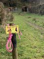
A worrying sign, maybe indicates game shooting?
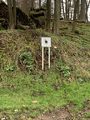
We think this had bullet dents in it, but no idea why
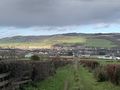
The view from where we turned back
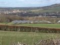
Solar panels on the nearby farm
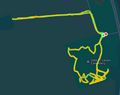
The route we took, including 40 minutes of cemetery searching


Achievements
KerrMcF and KerrMcF's dad earned the Prize poultry Consolation Prize
|

| Expedition Navigation | ||
|---|---|---|
| KerrMcF's expeditions | Next | |
| KerrMcF's Dad's expeditions | No Next Yet | |