Difference between revisions of "2024-03-24 47 -122"
Coyotebush (talk | contribs) ([live picture]Sandwich and bicycle [https://openstreetmap.org/?mlat=47.63988611&mlon=-122.30236111&zoom=16 @47.6399,-122.3024]) |
(→Participants) |
||
| (28 intermediate revisions by 4 users not shown) | |||
| Line 23: | Line 23: | ||
* [[User:Coyotebush|coyotebush]] | * [[User:Coyotebush|coyotebush]] | ||
| + | * [[User:...|...]] | ||
| + | * [[User:Zebburkeconte|zebburkeconte]] and friend Felix | ||
== Plans == | == Plans == | ||
| − | |||
| − | * Bike. Either around noon directly from morning plans, or mid-afternoon from home. [[User:Coyotebush| | + | * Bike. Either around noon directly from morning plans, or mid-afternoon from home. [[User:Coyotebush|coyotebush]] ([[User talk:Coyotebush|talk]]) 19:02, 23 March 2024 (UTC) |
| + | * Walk to Light Rail station by house, take Light Rail down to UW station, take bus closer, then walk to hashpoint. [[User:...|...]] ([[User talk:...|talk]]) | ||
== Expedition == | == Expedition == | ||
| − | + | === [[User:Coyotebush|coyotebush]] === | |
| + | Intermittent sun throughout the morning, gradually warming up. Not seeing any other interest in this point, I figured as long as I was out and about, I might as well take the opportunity for a loop route and lunch in a new neighborhood. | ||
| + | * Joke's on you, there was interest in the point, I just forgot to put it on the page :L. [[User:...|...]] ([[User talk:...|talk]]) 05:23, 25 March 2024 (UTC) | ||
| − | *Lunch nearby first -- [[User:Coyotebush| | + | * The joke, in fact, is on both of you :) [[User:Zebburkeconte|Zebburkeconte]] ([[User talk:Zebburkeconte|talk]]) |
| − | == | + | |
| − | + | Near the University of Washington campus, I encountered evidence of a running event - apparently the Cherry Blossom Run. Indeed, Seattle neighborhood streets are beautiful right now with blooming cherry, plum, magnolia, and such. Dodged a bunch of pedestrians likely visiting UW's famous cherry trees before navigating through the long-running construction at the Montlake/520 interchange. | |
| + | |||
| + | Next a cafe stop in the Montlake neighborhood's small business district (which also contains a good bike shop). Ate a sandwich there and took a treat for later. | ||
| + | |||
| + | *Lunch nearby first -- [[User:Coyotebush|coyotebush]] ([[User talk:Coyotebush|talk]]) [https://openstreetmap.org/?mlat=47.63979199&mlon=-122.30231290&zoom=16 @47.6398,-122.3023] 12:12, 24 March 2024 (PDT) | ||
| + | |||
| + | Then it was a straight shot uphill on 4-lane 24th Ave E. A surprisingly challenging climb. There was steady traffic coming the other way, but little enough in my direction that cars *could* easily change lanes to pass me... not that all of them fully did. | ||
| + | |||
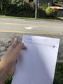
| + | I pulled over just before E Highland Dr, then realized I could legitimately use the center turn lane for a left turn there. While doing so I carefully paused to sneak a screenshot. Admired some views, but a selfie completely slipped my mind until much later. | ||
| + | |||
| + | Escaped the traffic for a bit via Interlaken Blvd, including the section closed to cars. | ||
| + | |||
| + | === [[User:...|...]] === | ||
| + | This was my first "official" expedition, and it went pretty well! Mostly according to plan- got to the station fine, but realized after several minutes of standing at the bus stop that it was closed. Decided to just walk about a mile and a half to the hashpoint, which made me regret wearing jeans. Not much of interest happened on the hike, but it was good overall. | ||
| + | |||
| + | Once I neared the point, I realized it was in the middle of a relatively busy street, so while I did pass through the hashpoint, I didn't actually get a photo or screenshot standing *at* it, because apparently I'm willing to walk through a busy street for an internet game, but not willing to take a selfie in one. Good to know for later. | ||
| + | |||
| + | PS: If I've made any mistakes on this page, someone tell me. I entirely forgot to add my plans until after the expedition, and I'm also still not sure about the formatting for two different people going to the same hashpoint. Hope everything looks fine :P. | ||
| + | |||
| + | * Nice! Sounds like you could claim a [[Public transport geohash achievement]] for the light rail ride if you want. [[User:Coyotebush|coyotebush]] ([[User talk:Coyotebush|talk]]) 01:43, 25 March 2024 (UTC) | ||
| + | |||
| + | === [[User:Zebburkeconte|zebburkeconte]] === | ||
| + | |||
| + | Did not get a chance to go to this point until 10:30pm, and did not get a chance to report here until a week later! | ||
| + | |||
| + | This was an exciting one because it was almost a Couch Potato Honorable Mention for me (just over 1km) and it would be a Couch Potato Honorable Mention for the friend I dragged along, Felix (600m), if he had an account here. | ||
| + | |||
| + | We walked to the hash, of course. Took selfie from the safety of the sidewalk but ran out into the street for the proof. | ||
== Photos == | == Photos == | ||
| Line 44: | Line 75: | ||
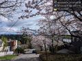
Image:2024-03-24_47_-122_coyotebush_1711317461683.jpg|Sandwich and bicycle [https://openstreetmap.org/?mlat=47.63988611&mlon=-122.30236111&zoom=16 @47.6399,-122.3024] | Image:2024-03-24_47_-122_coyotebush_1711317461683.jpg|Sandwich and bicycle [https://openstreetmap.org/?mlat=47.63988611&mlon=-122.30236111&zoom=16 @47.6399,-122.3024] | ||
| + | |||
| + | Image:2024-03-24_47_-122_coyotebush_1711317614699.jpg|View from northwest (point is between the two turn arrows) | ||
| + | |||
| + | Image:2024-03-24_47_-122_coyotebush_1711317654257.jpg|Middle of the road screenshot | ||
| + | |||
| + | Image:2024-03-24_47_-122_coyotebush_1711317681473.jpg|View from southeast [https://openstreetmap.org/?mlat=47.63024167&mlon=-122.30149444&zoom=16 @47.6302,-122.3015] | ||
| + | |||
| + | Image:2024-03-24_47_-122_coyotebush_1711317744134.jpg|Looking east, with blossoms [https://openstreetmap.org/?mlat=47.63028056&mlon=-122.30176944&zoom=16 @47.6303,-122.3018] | ||
| + | |||
| + | Image:2024-03-24_47_-122_coyotebush_1711317773057.jpg|Very belated selfie [https://openstreetmap.org/?mlat=47.65248333&mlon=-122.32047778&zoom=16 @47.6525,-122.3205] | ||
| + | |||
| + | Image:2024-03-24_47_-122_..._inconvenient.JPEG|The bus stop was closed :(. | ||
| + | |||
| + | Image:2024-03-24_47_-122_hashptselfie.png|Just in front of the hashpoint- face censored for your viewing enjoyment (and safety). | ||
| + | |||
| + | Image:2024-03-24_47_-122_..._pointpointed.JPEG|Some nerd pointing to the point. | ||
| + | |||
| + | Image:2024-03-24_47_-122_..._montlakecut!.JPEG|The Montlake Cut, as seen on the way back from the hashpoint. | ||
| + | |||
| + | Image:2024-03-24_47_-122_..._madpassenger.JPEG|Seems like someone was slightly more displeased at the 48 than I was. Slightly. | ||
| + | |||
| + | Image:2024-03-24_47_-122_..._railsonchalk.MP4|Very pleasant train noises. | ||
| + | |||
| + | Image:Costlyburger.JPEG|Victory burger. | ||
| + | |||
| + | |||
| + | Image:2024-03-24_47_-122_Zebburkeconte_1711901754397.jpg|Stupid Grin: Zeb and Felix | ||
| + | |||
| + | Image:2024-03-24_47_-122_Zebburkeconte_1711901776180.jpg|Proof: Zeb and Felix | ||
</gallery> | </gallery> | ||
| Line 50: | Line 110: | ||
<!-- Add any achievement ribbons you earned below, or remove this section --> | <!-- Add any achievement ribbons you earned below, or remove this section --> | ||
| − | + | {{bicycle geohash | |
| − | + | | latitude = 47 | |
| − | + | | longitude = -122 | |
| − | [[ | + | | date = 2024-03-24 |
| + | | name = coyotebush | ||
| + | }} | ||
| + | |||
| + | {{land geohash | ||
| + | | latitude = 47 | ||
| + | | longitude = -122 | ||
| + | | date = 2024-03-24 | ||
| + | | name = [[User:...|...]] | ||
| + | }} | ||
| + | ("With much difficulty." -[[User:...|...]]) | ||
| + | |||
| + | {{Two to the N achievement | ||
| + | | count = 0 | ||
| + | | latitude = 47 | ||
| + | | longitude = -122 | ||
| + | | date = 2024-03-24 | ||
| + | | name = [[User:...|...]] | ||
| + | | reached = true | ||
| + | }} | ||
| + | ("Of *course* I'm going to claim a badge for reaching 1 hashpoint, have you *met* me?" -[[User:...|...]]) | ||
| − | + | {{Public transport geohash | |
| + | | latitude = 47 | ||
| + | | longitude = -122 | ||
| + | | date = 2024-03-24 | ||
| + | | name = [[User:...|...]] | ||
| + | | busline = the 1 Line | ||
| + | }} | ||
| + | ("Conspiracy theory: the light rail is electric because otherwise people would call it the 'gaslight rail'." -[[User:...|...]]) | ||
| − | + | __NOTOC__ | |
| − | |||
| − | |||
| − | |||
| − | |||
| − | |||
[[Category:Expeditions]] | [[Category:Expeditions]] | ||
| − | |||
[[Category:Expeditions with photos]] | [[Category:Expeditions with photos]] | ||
| − | |||
| − | |||
| − | |||
| − | |||
| − | |||
[[Category:Coordinates reached]] | [[Category:Coordinates reached]] | ||
| − | + | {{location|US|WA|KN}} | |
| − | |||
| − | |||
| − | |||
| − | |||
| − | |||
| − | |||
| − | |||
| − | |||
| − | |||
| − | |||
| − | |||
| − | |||
| − | |||
| − | |||
| − | |||
| − | |||
| − | |||
Latest revision as of 16:24, 31 March 2024
| Sun 24 Mar 2024 in Seattle: 47.6304644, -122.3016494 geohashing.info google osm bing/os kml crox |
Location
Middle of 24th Ave E in eastern Capitol Hill
Participants
- coyotebush
- ...
- zebburkeconte and friend Felix
Plans
- Bike. Either around noon directly from morning plans, or mid-afternoon from home. coyotebush (talk) 19:02, 23 March 2024 (UTC)
- Walk to Light Rail station by house, take Light Rail down to UW station, take bus closer, then walk to hashpoint. ... (talk)
Expedition
coyotebush
Intermittent sun throughout the morning, gradually warming up. Not seeing any other interest in this point, I figured as long as I was out and about, I might as well take the opportunity for a loop route and lunch in a new neighborhood.
- Joke's on you, there was interest in the point, I just forgot to put it on the page :L. ... (talk) 05:23, 25 March 2024 (UTC)
- The joke, in fact, is on both of you :) Zebburkeconte (talk)
Near the University of Washington campus, I encountered evidence of a running event - apparently the Cherry Blossom Run. Indeed, Seattle neighborhood streets are beautiful right now with blooming cherry, plum, magnolia, and such. Dodged a bunch of pedestrians likely visiting UW's famous cherry trees before navigating through the long-running construction at the Montlake/520 interchange.
Next a cafe stop in the Montlake neighborhood's small business district (which also contains a good bike shop). Ate a sandwich there and took a treat for later.
- Lunch nearby first -- coyotebush (talk) @47.6398,-122.3023 12:12, 24 March 2024 (PDT)
Then it was a straight shot uphill on 4-lane 24th Ave E. A surprisingly challenging climb. There was steady traffic coming the other way, but little enough in my direction that cars *could* easily change lanes to pass me... not that all of them fully did.
I pulled over just before E Highland Dr, then realized I could legitimately use the center turn lane for a left turn there. While doing so I carefully paused to sneak a screenshot. Admired some views, but a selfie completely slipped my mind until much later.
Escaped the traffic for a bit via Interlaken Blvd, including the section closed to cars.
...
This was my first "official" expedition, and it went pretty well! Mostly according to plan- got to the station fine, but realized after several minutes of standing at the bus stop that it was closed. Decided to just walk about a mile and a half to the hashpoint, which made me regret wearing jeans. Not much of interest happened on the hike, but it was good overall.
Once I neared the point, I realized it was in the middle of a relatively busy street, so while I did pass through the hashpoint, I didn't actually get a photo or screenshot standing *at* it, because apparently I'm willing to walk through a busy street for an internet game, but not willing to take a selfie in one. Good to know for later.
PS: If I've made any mistakes on this page, someone tell me. I entirely forgot to add my plans until after the expedition, and I'm also still not sure about the formatting for two different people going to the same hashpoint. Hope everything looks fine :P.
- Nice! Sounds like you could claim a Public transport geohash achievement for the light rail ride if you want. coyotebush (talk) 01:43, 25 March 2024 (UTC)
zebburkeconte
Did not get a chance to go to this point until 10:30pm, and did not get a chance to report here until a week later!
This was an exciting one because it was almost a Couch Potato Honorable Mention for me (just over 1km) and it would be a Couch Potato Honorable Mention for the friend I dragged along, Felix (600m), if he had an account here.
We walked to the hash, of course. Took selfie from the safety of the sidewalk but ran out into the street for the proof.
Photos
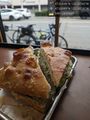
Sandwich and bicycle @47.6399,-122.3024
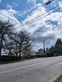
View from northwest (point is between the two turn arrows)
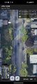
Middle of the road screenshot
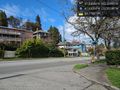
View from southeast @47.6302,-122.3015
Looking east, with blossoms @47.6303,-122.3018
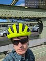
Very belated selfie @47.6525,-122.3205
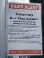
The bus stop was closed :(.
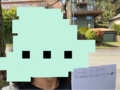
Just in front of the hashpoint- face censored for your viewing enjoyment (and safety).
Some nerd pointing to the point.
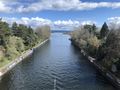
The Montlake Cut, as seen on the way back from the hashpoint.

Seems like someone was slightly more displeased at the 48 than I was. Slightly.
Very pleasant train noises.
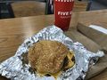
Victory burger.
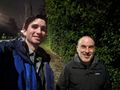
Stupid Grin: Zeb and Felix

Proof: Zeb and Felix


Achievements
coyotebush earned the Bicycle geohash achievement
|
... earned the Land geohash achievement
|
("With much difficulty." -...)

("Of *course* I'm going to claim a badge for reaching 1 hashpoint, have you *met* me?" -...)
... earned the Public transport geohash achievement
|
("Conspiracy theory: the light rail is electric because otherwise people would call it the 'gaslight rail'." -...)