Difference between revisions of "2024-03-30 50 8"
Green guy! (talk | contribs) (Write expedition report text, update categories, add title image, text improvements, remove obsolete comments) |
m (Location) |
||
| (3 intermediate revisions by 2 users not shown) | |||
| Line 1: | Line 1: | ||
| − | |||
{{meetup graticule | {{meetup graticule | ||
| lat={{#explode:{{SUBPAGENAME}}| |1}} | | lat={{#explode:{{SUBPAGENAME}}| |1}} | ||
| Line 8: | Line 7: | ||
== Location == | == Location == | ||
In a forest area, about 30 meters away from the closest track road, in Offenbach county, Hesse, Germany. The closest settlement is Neurott (a suburb/quarter of Langen) in southeast direction. | In a forest area, about 30 meters away from the closest track road, in Offenbach county, Hesse, Germany. The closest settlement is Neurott (a suburb/quarter of Langen) in southeast direction. | ||
| + | |||
| + | This day’s weather: completely clouded | ||
== Participants == | == Participants == | ||
| Line 49: | Line 50: | ||
I already earned these from an earlier geohash, but fulfilled the conditions again on this one. | I already earned these from an earlier geohash, but fulfilled the conditions again on this one. | ||
{{#vardefine:ribbonwidth|100%}} | {{#vardefine:ribbonwidth|100%}} | ||
| − | + | {{OpenStreetMap achievement | |
| latitude = {{#explode:{{SUBPAGENAME}}| |1}} | | latitude = {{#explode:{{SUBPAGENAME}}| |1}} | ||
| longitude = {{#explode:{{SUBPAGENAME}}| |2}} | | longitude = {{#explode:{{SUBPAGENAME}}| |2}} | ||
| date = {{#explode:{{SUBPAGENAME}}| |0}} | | date = {{#explode:{{SUBPAGENAME}}| |0}} | ||
| − | | OSMlink = | + | | OSMlink = 149395995 |
| − | | OSMlink2 = | + | | OSMlink2 = 149398353 |
| − | |||
| name = [[User:Green guy!|Green guy!]] ([[User talk:Green guy!|talk]]) | | name = [[User:Green guy!|Green guy!]] ([[User talk:Green guy!|talk]]) | ||
| − | }} | + | }} |
{{land geohash | {{land geohash | ||
| latitude = {{#explode:{{SUBPAGENAME}}| |1}} | | latitude = {{#explode:{{SUBPAGENAME}}| |1}} | ||
| Line 67: | Line 67: | ||
__NOTOC__ | __NOTOC__ | ||
| − | |||
| − | |||
| − | |||
| − | |||
| − | |||
[[Category:Expeditions]] | [[Category:Expeditions]] | ||
[[Category:Expeditions with photos]] | [[Category:Expeditions with photos]] | ||
| − | |||
[[Category:Coordinates reached]] | [[Category:Coordinates reached]] | ||
| + | {{location|DE|HE|OF}} | ||
Latest revision as of 04:42, 2 April 2024
| Sat 30 Mar 2024 in 50,8: 50.0043165, 8.6374159 geohashing.info google osm bing/os kml crox |

Location
In a forest area, about 30 meters away from the closest track road, in Offenbach county, Hesse, Germany. The closest settlement is Neurott (a suburb/quarter of Langen) in southeast direction.
This day’s weather: completely clouded
Participants
- Green guy! (talk)
- Green guy!’s mother (no consent to publish photos of her)
- Green guy!’s father (no consent to publish photos of him)
Plans
Not in the mood for thorough planning, so it’s quick and dirty:
- Drive to Neurott in the afternoon
- Might be a bit difficult to park our car there …
- Go on a walk to visit the hashpoint
- Visit a nearby cafe and/or do the groceries
- Drive back home
- (Enjoy the rest of Holy Saturday)
Expedition
My parents and I drove to the quarter of Neurott. As expected, it was a bit tricky to find a spot to park our car there, but we were successful after a short while.
It was also a bit tricky to find a spot to actually leave the residential area and enter the forest, as OpenStreetMap shows quite a lot of barriers. We found a way and successfully walked to the hashpoint, reaching coordinates a few minutes after 4 pm CET. (I’m mentioning the time zone because the kind-of-useless CEST, better known as daylight-savings time, takes effect the next day.) While walking back to our car, I had the opportunity to trace a path which is not mapped yet in OpenStreetMap. Also, I surveyed another spot that didn’t look possible to trespass due to a construction site, but actually was.
After finishing our expedition, we felt like enjoying some cake and/or ice cream in a café in Langen. My parents opted for the family-operated EisAnita which offers home-made pastry and ice cream, and so we drove there. Because it was still March, there was no ice cream available, so we savored coffee and cake. It was a calm and nice place.
Tracklog: Walking to the hashpoint
- Direction: south => north for a while => west => north (reaching hashpoint) => south => east (via a path not mapped yet in OSM) => south => east
- GPS accuracy: medium–good
- Markers show all locations where I took photos (including some photos taken separate from the tracklog) – nearly all of them are taken for OpenStreetMap surveying and not uploaded here.
Pictures
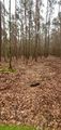
Almost at the hashpoint
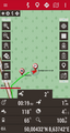
Coordinates reached
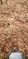
The hashpoint’s forest floor
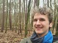
Funny grin
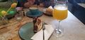
A slice of home-made marble cake at EisAnita, accompanied by a glass of freshly squeezed orange juice


Achievements
Recurring
I already earned these from an earlier geohash, but fulfilled the conditions again on this one.
Green guy! (talk) earned the OpenStreetMap achievement
|
Green guy! (talk) earned the Land geohash achievement
|
And no, drag-along doesn’t count as recurring because my parents are now sort-of familiar with the concept of geohashing (apart from not comprehending the Algorithm’s details).