|
|
| Line 35: |
Line 35: |
| | | | |
| | __NOTOC__ | | __NOTOC__ |
| − | <!-- =============== USEFUL CATEGORIES FOLLOW ================
| |
| − | Delete the next line ONLY if you have chosen the appropriate categories below. If you are unsure, don't worry. People will read your report and help you with the classification. -->
| |
| − | [[Category:New report]]
| |
| | | | |
| − | <!-- ==REQUEST FOR TWITTER BOT== Please leave either the New report or the Expedition planning category in as long as you work on it. This helps the twitter bot a lot with announcing the right outcome at the right moment. -->
| |
| − |
| |
| − | <!-- Potential categories. Please include all the ones appropriate to your expedition -->
| |
| − | <!-- If this is a planning page:
| |
| − | [[Category:Expedition planning]]
| |
| − | -->
| |
| − |
| |
| − | <!-- If all those plans are never acted upon, change [[Category:Expedition planning]] to [[Category:Not reached - Did not attempt]]. -->
| |
| − |
| |
| − | <!-- An actual expedition:
| |
| | [[Category:Expeditions]] | | [[Category:Expeditions]] |
| − | -- and one or more of --
| |
| | [[Category:Expeditions with photos]] | | [[Category:Expeditions with photos]] |
| − | [[Category:Expeditions with videos]]
| |
| − | [[Category:Expedition without GPS]]
| |
| − | -->
| |
| − |
| |
| − | <!-- if you reached your coords:
| |
| | [[Category:Coordinates reached]] | | [[Category:Coordinates reached]] |
| − |
| |
| − |
| |
| − | --><!-- or if you failed :(
| |
| − | [[Category:Coordinates not reached]]
| |
| − | -- and a reason --
| |
| − | When there is a natural obstacle between you and the target:
| |
| − | [[Category:Not reached - Mother Nature]]
| |
| − |
| |
| − | When there is a man-made obstacle between you and the target:
| |
| − | [[Category:Not reached - No public access]]
| |
| − |
| |
| − | When you failed get your GPS, car, bike or such to work:
| |
| − | [[Category:Not reached - Technology]]
| |
| − |
| |
| − | When you went to an alternate location instead of the actual geohash:
| |
| − | [[Category:Not reached - Attended alternate location]]
| |
| − |
| |
| − | (Don't forget to delete this final close comment marker) -->
| |
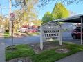
Location
In an apartment complex on Kinnaman Road.
Participants
Expedition
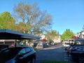
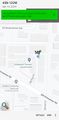
I took some friends to the airport at 6:30, then drove over to Beaverton, had a light breakfast, and did a little grocery shopping. Then, I parked at the Tualatin Hills Nature Park and ran about two miles to the hashpoint, which was -- perhaps not surprisingly -- fairly unremarkable. Then I finished my run, my errands, and eventually my day and week.
Photos
Inspiring message visible from the hashpoint
Achievements