Difference between revisions of "2024-05-08 34 -118"
m (Location) |
|||
| (One intermediate revision by the same user not shown) | |||
| Line 1: | Line 1: | ||
| − | <!-- [[Image:{{{image|IMAGE}}}|thumb|left]] --> | + | <!-- TODO: [[Image:{{{image|IMAGE}}}|thumb|left]] --> |
| − | {{meetup graticule | + | {{meetup graticule|lat=34|lon=-118|date=2024-05-08}} |
| − | | lat= | ||
| − | | lon= | ||
| − | | date= | ||
| − | }} | ||
== Location == | == Location == | ||
| − | The hash is in a dirt area off the road near Magic Mountain. Google's Street View from 6 months ago shows some piles of dirt and a freestanding gate we can walk past. Behind the hash is a ditch with a dry [https://wiki.openstreetmap.org/wiki/Tag:tunnel=culvert?uselang=en culvert] that we could also walk down. (Apple's satellite imagery is quite old, showing actual construction that no longer appears to be there.) | + | The hash is in a dirt area off the road near Magic Mountain and the new Valencia development. Google's Street View from 6 months ago shows some piles of dirt and a freestanding gate we can walk past. Behind the hash is a ditch with a dry [https://wiki.openstreetmap.org/wiki/Tag:tunnel=culvert?uselang=en culvert] that we could also walk down. (Apple's satellite imagery is quite old, showing actual construction that no longer appears to be there.) |
== Participants == | == Participants == | ||
| Line 14: | Line 10: | ||
== Plans == | == Plans == | ||
| − | This morning, I ([[User:Jeremy|Jeremy]]) got a notification from my geohash-calculating [https://apps.apple.com/us/app/shortcuts/id915249334 shortcut] that the geohash was accessible. | + | This morning, I ([[User:Jeremy|Jeremy]]) got a notification from my geohash-calculating [https://apps.apple.com/us/app/shortcuts/id915249334 shortcut] that the geohash was accessible. My best friend [[User:Lehonk|Ethan]] and I have been waiting for months for our first hash, so this is really exciting. Today happens to be a really good day, our schedules are clear and the weather is great. There are four geocaches nearby and the [https://maps.app.goo.gl/R5n6f7vYWuRfZ43v6 Iron Horse trailhead] is close, so we will try to take our bikes down to the trailhead and bike around. |
== Expedition == | == Expedition == | ||
| − | + | We loaded up our bikes and drove down to the Iron Horse trailhead. We set out on our bikes (you can see the moment in the tracklog where I realised "hey, I should record") and crossed some busy intersections. Thankfully, the buttons for telling the speeding Teslas to stop worked. We didn't realize from the map how big the new development is, the field the geohash was in looked way smaller from the sky. ... | |
== Tracklog == | == Tracklog == | ||
| − | + | I never paused the tracking, so you get to see us wandering around at the geohash and geocaches. | |
| + | |||
| + | {{tracklog|2024-05-08 34 -118 Jeremy's watch.gpx}} | ||
== Photos == | == Photos == | ||
| − | + | (better pictures and videos will be uploaded later today (2024-05-09)) | |
| − | + | ||
| − | |||
<gallery perrow="5"> | <gallery perrow="5"> | ||
| − | + | Image:2024-05-08_34_-118_Jeremy_1715209856632.jpg|Arrival at the Iron Horse trailhead | |
| − | Image:2024-05-08_34_-118_Jeremy_1715209856632.jpg| | + | Image:2024-05-08_34_-118_Jeremy_1715211259379.jpg|We made it to the geohash! |
| − | + | Image:2024-05-08_34_-118_Jeremy_1715211455258.jpg|Putting a [http://poster.geo.crox.net/poster/2024-05-08_34_-118 poster] on the no trespassing sign - "It isn't trespassing if you don't get caught" - Jeremy | |
| − | Image:2024-05-08_34_-118_Jeremy_1715211259379.jpg|We made it! | + | Image:2024-05-08 34 -118 Adventure Avenue.jpg|We biked down Adventure Avenue - "That's so cliché. I love it" - Ethan |
| − | |||
| − | |||
</gallery> | </gallery> | ||
== Achievements == | == Achievements == | ||
{{#vardefine:ribbonwidth|100%}} | {{#vardefine:ribbonwidth|100%}} | ||
| − | {{land geohash | latitude = 34 | longitude = -118 | date = 2024-05-08 | name = Jeremy and Ethan }} | + | <!-- TODO: add images to achievements --> |
| + | {{land geohash | ||
| + | | latitude=34|longitude=-118|date=2024-05-08 | ||
| + | | name=[[User:Jeremy|Jeremy]] and [[User:Lehonk|Ethan]] | ||
| + | }} | ||
| + | {{bicycle geohash | ||
| + | | latitude=34|longitude=-118|date=2024-05-08 | ||
| + | | name=[[User:Jeremy|Jeremy]] and [[User:Lehonk|Ethan]] | ||
| + | | distance=7 miles | ||
| + | | bothways=true | ||
| + | }} | ||
| + | {{Two to the N achievement | ||
| + | | lat=34|lon=-118|date=2024-05-08 | ||
| + | | name=[[User:Jeremy|Jeremy]] and [[User:Lehonk|Ethan]] | ||
| + | | count=0 | ||
| + | }} | ||
__NOTOC__ | __NOTOC__ | ||
| − | |||
| − | |||
[[Category:Expeditions]] | [[Category:Expeditions]] | ||
[[Category:Expeditions with photos]] | [[Category:Expeditions with photos]] | ||
| − | <!-- | + | <!-- TODO: [[Category:Expeditions with videos]] --> |
[[Category:Coordinates reached]] | [[Category:Coordinates reached]] | ||
{{location|US|CA|LO}} | {{location|US|CA|LO}} | ||
Revision as of 17:26, 9 May 2024
| Wed 8 May 2024 in 34,-118: 34.4130363, -118.5996918 geohashing.info google osm bing/os kml crox |
Location
The hash is in a dirt area off the road near Magic Mountain and the new Valencia development. Google's Street View from 6 months ago shows some piles of dirt and a freestanding gate we can walk past. Behind the hash is a ditch with a dry culvert that we could also walk down. (Apple's satellite imagery is quite old, showing actual construction that no longer appears to be there.)
Participants
Plans
This morning, I (Jeremy) got a notification from my geohash-calculating shortcut that the geohash was accessible. My best friend Ethan and I have been waiting for months for our first hash, so this is really exciting. Today happens to be a really good day, our schedules are clear and the weather is great. There are four geocaches nearby and the Iron Horse trailhead is close, so we will try to take our bikes down to the trailhead and bike around.
Expedition
We loaded up our bikes and drove down to the Iron Horse trailhead. We set out on our bikes (you can see the moment in the tracklog where I realised "hey, I should record") and crossed some busy intersections. Thankfully, the buttons for telling the speeding Teslas to stop worked. We didn't realize from the map how big the new development is, the field the geohash was in looked way smaller from the sky. ...
Tracklog
I never paused the tracking, so you get to see us wandering around at the geohash and geocaches.
Photos
(better pictures and videos will be uploaded later today (2024-05-09))
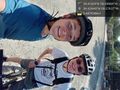
Arrival at the Iron Horse trailhead
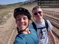
We made it to the geohash!
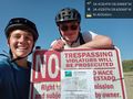
Putting a poster on the no trespassing sign - "It isn't trespassing if you don't get caught" - Jeremy
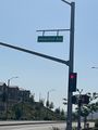
We biked down Adventure Avenue - "That's so cliché. I love it" - Ethan


Achievements
Jeremy and Ethan earned the Land geohash achievement
|
Jeremy and Ethan earned the Bicycle geohash achievement
|
