Difference between revisions of "Manukau City, New Zealand"
m (Replacing Peeron with Geohashing.info) |
m (per Renaming Proposal) |
||
| Line 69: | Line 69: | ||
[[Category:Inactive graticules]] | [[Category:Inactive graticules]] | ||
[[Category:New Zealand]] | [[Category:New Zealand]] | ||
| − | [[Category: | + | [[Category:Unlocked graticules]] |
Revision as of 02:05, 20 March 2024

|
Latest Coordinates and Map Quick-Links | |
|---|---|
| Wednesday 2024-05-22 | -37.2756314, 174.2193894 |
| Thursday 2024-05-23 | -37.0493427, 174.9907290 |
| Glinks Gully | Auckland | Coromandel |
| -37,173 | Manukau City | Hamilton |
| -38,173 | Waitara | South Waikato |
|
Today's location: geohashing.info google osm bing/os kml crox | ||


Contents
Description
The Manukau City graticule encompasses the southern portion of Auckland - New Zealands biggest city. The main attraction of Manukau City itself is probably Rainbows End[1], a theme park that is orders of magnitude less exciting than the Australian counterparts. The population is dense and reached 329,300 as at 2006 [2]. It also contains Auckland International Airport [3].
The graticule itself contains the southern extremities of the Waitakere Ranges, the Manukau Harbour, Awhitu Penninsula, and extends southwards towards Raglan, a hippie surfer community, housing the country's best left hand point break. Over half of this graticule comprises the Tasman Ocean.
Statistics
![]() Manukau City was deflowered by AMADANON Inc. on 2008-12-16 -37 174, although no proof was provided, and AMADANON Inc. was never to be seen again! (grumble)
Manukau City was deflowered by AMADANON Inc. on 2008-12-16 -37 174, although no proof was provided, and AMADANON Inc. was never to be seen again! (grumble)
![]() as of 8/9/2011 11:20:25 AM UTC,
as of 8/9/2011 11:20:25 AM UTC,
- Manukau City is not even in the top 100 most active graticules in the world;
Geohashes Reached
- 2017-01-04 - Jacksonz - Totara Road, Manurewa
- 2009-04-18 - TunezNZ - Road, Karaka
- 2009-01-05 - TunezNZ and jonootto - Bush, Waitakere Ranges
- 2008-12-16 - AMADANON Inc. went on an expedition and claimed Virgin Graticule - although no proof was provided...
Geohashes Not Reached
- 2010-10-07 - Greenslime - Pararaha River Valley - thwarted by the Pararaha river
Locals
Visitors
Photo Gallery
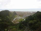
Pararaha River Valley
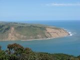
The south cliffs of the Manukau Heads

