Difference between revisions of "Montgomery, Alabama"
From Geohashing
imported>N76lima m (Added categories) |
m (Replacing Peeron with Geohashing.info) |
||
| (16 intermediate revisions by 9 users not shown) | |||
| Line 1: | Line 1: | ||
{{graticule | {{graticule | ||
| − | | | + | | lat= 32 |
| − | |n = [[Birmingham, Alabama|Birmingham | + | | lon= -86 |
| − | |ne = [[Anniston, Alabama|Anniston | + | | nw = [[Tuscaloosa, Alabama|Tuscaloosa]] |
| − | | | + | | n = [[Birmingham, Alabama|Birmingham]] |
| − | | | + | | ne = [[Anniston, Alabama|Anniston]] |
| − | | | + | | w = [[Talladega National Forest, Alabama|Talladega National Forest]] |
| − | |sw = [[Monroeville, Alabama|Monroeville | + | | name = [[Montgomery, Alabama|Montgomery]] |
| − | | | + | | e = [[Auburn, Alabama|Auburn]] |
| − | | | + | | sw = [[Monroeville, Alabama|Monroeville]] |
| − | + | | s = [[Andalusia, Alabama|Andalusia]] | |
| + | | se = [[Dothan, Alabama|Dothan]] | ||
}} | }} | ||
| − | The Montgomery graticule is at latitude 32, longitude -86. The graticule contains all of the greater Montgomery metropolitan area. In addition, it extends northeastward to the outskirts of Alexander City, AL, north to Jemison, AL, and west to the outskirts of Selma, AL. | + | The Montgomery graticule is at latitude 32, longitude -86. The [[graticule]] contains all of the greater Montgomery metropolitan area. In addition, it extends northeastward to the outskirts of Alexander City, AL, north to Jemison, AL, and west to the outskirts of Selma, AL. |
'''Today's Location:''' | '''Today's Location:''' | ||
| − | + | {{Today's location|lat=32|lon=-86|text=Montgomery, AL}} | |
== Activities == | == Activities == | ||
| + | 24 July 08 Today's site is in the water of Lake Martin. Got a boat? --N76Lima | ||
| + | |||
| + | [[2008-06-21 32 -86|21 Jun 08]] - [[User:N76lima|N76Lima]], ([[Birmingham, Alabama|Birmingham]] resident) will attempt the hash site (N32°58.759', W86°36.8377') for Saturday. Going before lunch, since it is on my way from Birmingham to Montgomery. A picture, if I make it! | ||
| + | |||
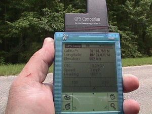
| − | + | [[Image:21Jun08GPS.jpg|left|thumbnail|Got close. From Highway 145, I was able to get the correct Latitude, but the Longitude was off by a couple hundred feet into VERY dense forest, and beyond the ditch I could see a fence, so it was someone's fenced land.]] | |
== Local Geohashers == | == Local Geohashers == | ||
[[Category:Alabama]] | [[Category:Alabama]] | ||
| − | [[Category: | + | [[Category:Inactive graticules]] |
Latest revision as of 17:14, 15 January 2022
| Tuscaloosa | Birmingham | Anniston |
| Talladega National Forest | Montgomery | Auburn |
| Monroeville | Andalusia | Dothan |
|
Today's location: geohashing.info google osm bing/os kml crox | ||
The Montgomery graticule is at latitude 32, longitude -86. The graticule contains all of the greater Montgomery metropolitan area. In addition, it extends northeastward to the outskirts of Alexander City, AL, north to Jemison, AL, and west to the outskirts of Selma, AL.
Today's Location:
Montgomery, AL
Activities
24 July 08 Today's site is in the water of Lake Martin. Got a boat? --N76Lima
21 Jun 08 - N76Lima, (Birmingham resident) will attempt the hash site (N32°58.759', W86°36.8377') for Saturday. Going before lunch, since it is on my way from Birmingham to Montgomery. A picture, if I make it!
