Difference between revisions of "Nelson, New Zealand"
From Geohashing
m (Marking as active due to a recent expedition) |
Quaternary (talk | contribs) (→Geohashes Reached) |
||
| Line 20: | Line 20: | ||
==Geohashes Reached== | ==Geohashes Reached== | ||
<!-- Note to editors: please keep the order from newest to oldest --> | <!-- Note to editors: please keep the order from newest to oldest --> | ||
| + | *[[2023-12-03 -41 173|2023-12-03]] - [[User:Quaternary|Quaternary]] near Chaytor Track, Mapua, Nelson, New Zealand | ||
*[[2015-04-06 -41 173|2015-04-06]] - [[User:Quaternary|Quaternary]] at Kekerengu Valley, Marlborough, New Zealand | *[[2015-04-06 -41 173|2015-04-06]] - [[User:Quaternary|Quaternary]] at Kekerengu Valley, Marlborough, New Zealand | ||
Revision as of 01:42, 9 December 2023
| Golden Bay | D'Urville Island | Paraparaumu |
| Motueka | Nelson | Wellington |
| Hanmer Springs | Kaikoura | Kekerengu |
|
Today's location: geohashing.info google osm bing/os kml crox | ||
Today's Location: Nelson, NZ
Nelson, New Zealand. A region (or most of it) known nationally as a centre for arts and beer. This graticule is split in two by the Wangamoa Mountains, with one half in the Nelson Region, and the other in Marlburough, known for it's wonderful food, epic sounds and beautiful landscapes.
Geohashes Reached
- 2023-12-03 - Quaternary near Chaytor Track, Mapua, Nelson, New Zealand
- 2015-04-06 - Quaternary at Kekerengu Valley, Marlborough, New Zealand
Failed Geohashes
Photo Gallery
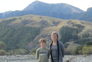
At the south-eastern corner of the graticule, looking west with the Southern Alps in the background.
