| Mon 22 Oct 1956 in Greifswalder Oie, Germany: 54.2501058, 13.9230429 geohashing.info google osm bing/os kml crox |
Location
Greifswalder Oie, MV, Germany.
With its 0.54km2 of surface this is actually 1 of the only two times, it has ever fallen here. The other one (1968-02-26) is out of reach for the general public since the Greifswalder Oie is a natural protected area. (All of this according to the shotgun implementation and the other values prior to 1950).
The Peroon map actually shows somewhere else (see here). I changed the date on the template so that I shows better what I was trying :)
Coordinated solution :D
Fippe saved the day and found that I almost walked by the 1956-10-22 hash, which doesn't show on Shotgun. So, expedition page has been moved here (from 1950-08-23).
Participants
Plans and motivation
Actually, for retrohashes it is not so interesting to read what the plans are, since I could have been planning them for weeks. It is more interesting to know, why this one? What is the motivation behind.
Well, today (the day of the expedition), is the so-to-say my special day, the day each one of us celebrates in its own way, and as a present I got this trip to the Greifswalder Oie. If we read its wikipedia article (in German), we can read that the Greifswalder Oie is often described as the "Helgoland of the Baltic Sea", and we all know what grate feat recently happened in Helgoland... ;)
So my plan these last days was to please the gods of Geohashing. I had been studying the market and I knew that if I made the right financial decisions I could get the market to reach the value of 27389.44. My intensive studies showed that if I did not invest in any company, I would have reached the value. Disturbing the market would make me fail. But I believe there is a reason no one has yet earned the Bill Gates achievement. And my calculations were 223.44 points off. And since the gods of Geohashing did not grant me this wish (or a nearer one)...
...I went to worship the old Gods of Geohashing, as a last option, which are more granting (and it turns out they're more tricky than expected ¿^^ SPOILER ALTER).
(In retrospective, once home, even if the the DJIA value would have been 27389.44, I couldn't have reach it by only 10 meters, since there is a fence, and could have been even more frustrating ¿^^)
Expedition on 2019-07-28
I woke up early since I wanted to seize the day. I had to take the ferry to Greifswalder Oie in Peenemünde but not until 13:45. But since there is the Historical Technical Museum, I visited it. Where "space flight" was born. And ethical combination of Nazis advancing in science and space flight, and constructing air weapons to kill thousands. If you ever find yourself in the area, I really recommend you this museum. It's really worth.
I spend nearly 2-3 hours there. After that I had a typical "Fischbrötchen" (you can't have anything else if you are in the Ostsee :P) and took the ferry.
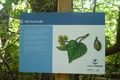
Only up to 50 persons are allowed per Day in the Greifswalder Oie and the ferry company which takes us, gives us 2 hours to roam the island. As I said before is a natural protected area. No leaving the marked paths. No people lives there. There are a few people (we could say scientists) which take care of the place and ring birds, and made their studies. We were welcomed by two of them and they did us a 20 min presentation in the Information Center talking us about the island; it's history and these kind of things.
After that the crowd went to the lighthouse (according to wikipedia, the most east one of Germany). A few of us did our own way. I needed more tranquillity. I had my binoculars with me so I did some bird watching. Beautiful. Seals can be seen on the island. I had no such luck. I also took the chance to search for two caches in the island.
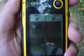
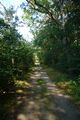
On my way through the island I went to the retrohash[1]. It is not only lucky that it once fell here, but that it fell exactly on the marked path[2]. In the forest area. I took the proof with my GPS and continued discovering the little hidden corners of the Greifswalder Oie[3]. The 2 hours past really fast.
After that it was time to leave the island. 1:30hours later I was again in Peenemünde. There I took the train to Zinnowitz, a town on the island of Usedom (Peenemünde is also in the island). It is a touristic town.... Oh my god, the amount of German tourists there are... The whole Usedom island is like this in the summer. I mean, it's a beautiful place but you must be ready to share it with this amount of people.
In Zinnowitz I had a beer, enjoyed the sunset, and took the last train to Greifswald. Exhausted.
Comments
Commenting my own expedition after knowing what happened with the retro-coordinates.
[1] Or did I?
[2] Yeah, sure, it fell here.
[3] While, inadvertently passing by the real retro-hash.
Tracklog
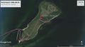
Closeup on the Greifswalder Oie


Photos
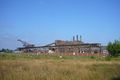
The museum in Peenemünde.
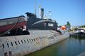
Russian submarine in Peenemünde.
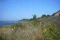
First impression of the Greifswalder Oie. Bird photobombing the picture.
Not all birds were alive.
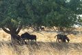
Sheep live in the island.
Retro hash reached (or maybe...).
Retro hash area (idem).
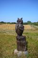
Sister of Winterbuche found.
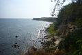
Active Steilküste of the island.
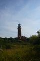
The most eastern lighthouse of Germany.
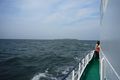
Leaving the island behind.
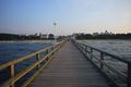
Seebrücke in Zinnowitz. Surprisingly had the second when the tourist where dispersed.
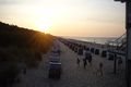
The most typical sunset in a Baltic beach.


Achievements
SastRe.O earned the Scientific curse of unaware blindness by trespassing denial Consolation Prize
|