2008-09-20 52 13

| Sat 20 Sep 2008 in 52,13: 52.5939233, 13.8365649 geohashing.info google osm bing/os kml crox |
Participants
Expedition
Meticulous planning and map studying is the key to a successful geohash trip. According to the photo footage they carefully browsed in advance, the trip for today would be leading them into the forest right next to a beach. A wonderful sunny place where they could easily provide for the Picnic Achievement which was still missing in their collection.
Relet met Hessophanes at his place, and they drove through the eastern outskirts of Berlin into the rural area of Brandenburg. The hash was close to lake Fängersee near the town of Strausberg, and they parked the car near the animal shelter in Wesendahl (at the northwestern edge of the lake). They grabbed their picnic equipment and started for the hashpoint, eager to continue to the beach after they had left proof of their visit.
Upon leaving the car they noticed that they had not written down or stored the coordinates for today's hash point anywhere. Fortunately that was nothing a quick phone call couldn't fix. While still phoning for the exact coordinates, they chose a first path leading south for their approach. Having looked up the exact location, they quickly found out they had to go the other way. They drove a little further by car, and then started a second approach.
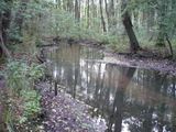
For a while they could follow a trail along the rear fence of the animal shelter - the constant barking and cooing from inside was pitiable and unsettling at the same time. Glad there weren't any raptors in there, though. Soon they were forced to leave the track and make their own way through the trees, heading directly for the lake shore. However the closer they came, the more runlets and rivulets got in their way and transformed the hitherto dry forest ground into a swampy disaster.
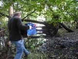
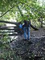
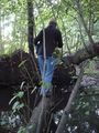
The hashpoint almost in sight, they were stopped by a stream too wide to jump across. First they followed it southwards, passing the fence of some nearby hut. Relet suggested to test their pole vaulting skills, but soon after he found a toppled tree that seemed solid enough to serve as a bridge. Hessophanes sank ankle-deep into the mud while he was scouting the best way to reach the bridge, whereas relet was attacked by devious ninja nettles that inhabited one end of the bridge.
Finally they reached the coordinates. There was no beach to be seen yet. Still, having brought the equipment, they decided to have a good picnic. The achievement said nothing about unfolding the picnic blanket, which wouldn't have been a wise idea at this place anyway, and so they made a very small picnic table and enjoyed some refreshments. Afterwards, they hid Geohashflashcache #5 at the spot.
The way beyond the hashpoint proved to be impassable, so they walked back the way they had come, over the bridge, around the fence and along the animal shelter. If the beach wasn't reachable this way, perhaps they could access it directly from the north? No luck. What looked like a beach on the satellite images and amateur photos of the spot turned out to be a belt of reed. Talk about good surveying. They had a second serving along the hiking paths, did some more surveying while searching for someone else's cache, and finally returned home.
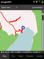
Tracklog
Gallery
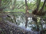
There Might Be Alligators!
But Who Cares?
Never cross a swamp without Picnic Box.

Across the "Bridge".
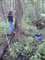
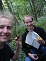
At the hash point.

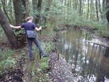
Stupid grin on swampy background.
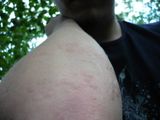
Invisible Ninja Nettles did this.
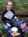
Worlds Smallest Picnic Table.
Cookies and Apples.
And here, too!
Back across the bridge
Alligators go home!
Dancing to the tune of "Alligators go home!"
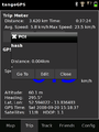
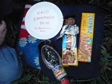
Coordinates.
Erratic paths.


