2009-10-12 41 -73
| Mon 12 Oct 2009 in 41,-73: 41.0135057, -73.9431125 geohashing.info google osm bing/os kml crox |
Location
Driveway of a business on Pegasus Ave. in Northvale, NJ.
Participants
Plans
I'll take I-287 north from here, which becomes I-287 E in New York State, then down the Palisades Parkway to NY 303 South. Pegasus Ave. is probably the first Dunkin Donuts after re-entering New Jersey.
A quick loop through the driveway, and get a picture of the tree on the north side of the building which seems to be right at the hashpoint.
Going home, I'll continue down Pegasus to Rte 303 and take local roads to pick up the Palisades Pkwy southbound again, and find the NJ Turnpike to the south end of I-287.
4:11PM Slight change in plans. I need to stop at a friend's place on the way back, so now I'm taking the NJ Turnpike up to the geohash, then I-287 W to 444 South, which becomes the Garden State Parkway, stop in Clifton, then back onto the Parkway to I-78 to get home.
Ribbons
Jevanyn achieved level 4 of the Minesweeper Geohash achievement
|
Jevanyn earned the XKCD-100 Achievement
|
Jevanyn earned the First Sip GeoSquishy Achievement
|
Expedition
The drive up from Somerville was a grind.
First, there was a truck fire on the NJ Turnpike in the vicinity of Elizabeth or Linden, a column of black, greasy smoke visible for 10 miles.
Further north, traffic was at a standstill for nearly an hour approaching the George Washington Bridge, which, unfortunately, is typical.
Then the exit I was looking for, wasn't there, forcing me to ad-lib at street level in Fort Lee. I had abandoned my hope of a Tron achievement before starting the journey, but if I hadn't, preserving it would have been nearly impossible at this point. Microsoft Bing mobile rescued me from a wrong turn, the voice recognition feature especially handy while driving.
The northward leg up the Palisades Parkway took me past my geohash of June 6th. In fact, needing to call my wife to let her know I was running late, I stopped at the same scenic overlook as that night.
I continued up the Palisades across the New York border, taking exit 5S onto NY route 303 south. A sports car with LED headlights kindly gave me a bump draft on the sharp off-ramp.
After another mile, I found the turn for Pegasus Road, complete with Dunkin Donuts anchoring a strip mall on one corner of the intersection. As this road bent to the south, an array of satellite dishes sat listening in the dark.
The office building was quiet, perhaps even vacant. I circled through the rear parking area, stopped near the tight clump of trees between the building and the driveway, snapped a few photos, and took a pinecone for a souvenir.
Photos
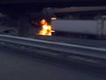
Burning truck
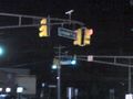
Livingston and Pegasus
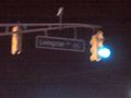
Livingston
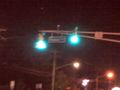
Pegasus
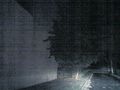
Tree
Closeup of Tree

Me in front of tree

Attacked by hideous trollClearer picture of me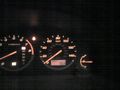
One-way mileage
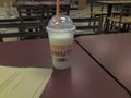
Coolatta = GeoSqushy?


