2010-12-27 52 1
| Mon 27 Dec 2010 in Norwich: 52.4830388, 1.7332708 geohashing.info google osm bing/os kml crox |
Contents
Location
A road hashpoint two kilometres from the most easterly point in the UK next to the fire station in Normanston Road, Lowestoft, Suffolk, UK.
Participants
Expedition
Neil went by car from Beccles to Lowestoft, passing the hashpoint at 00:00:14 GMT and at 52km/h, the legal speed limit +/- speedometer accuracy. The temperature was -0.5C. A slower pass was made to verify that the hashpoint fell inside the circle of uncertainty while driving past. This was quite an uninteresting expedition although it gained three achievements (four if you include Land Geohash).
Arriving only a few seconds after midnight was quite interesting. The GPS ETA and Time of Day displays were used and a small diversion was made to kill about four minutes. A final adjustment, going round a roundabout twice enabled a timely arrival on the first attempt. It would not have been safe or even possible in the dark to photograph the GPS or speedometer so a screenshot from Garmin's Mapsource must suffice for evidence. The whole of the UK has been at sub zero temperatures every night for many days now.
Photo Gallery
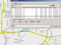
Garmin Mapsource Evidence

Achievements
Sourcerer earned the Speed racer achievement
|
Sourcerer earned the Frozen Geohash Achievement
|
Sourcerer earned the Midnight Geohash achievement
|
Expeditions and Plans
| 2010-12-27 | ||
|---|---|---|
| Princeton, Missouri | Someone went | Southbound Interstate 35 near Lamoni, Iowa |
| Norwich, United Kingdom | Sourcerer | A road hashpoint two kilometres from the most easterly point in the UK next... |
| Rovaniemi, Finland | isopekka, the dog | In the city of Rovaniemi |
Sourcerer's Expedition Links
2010-12-26_52_0 - 2010-12-27_52_1 - 2010-12-31_52_1 - KML file download of Sourcerer's expeditions for use with Google Earth.