2010-12-26 52 0
| Sun 26 Dec 2010 in Cambridge: 52.7216583, 0.7087315 geohashing.info google osm bing/os kml crox |
Contents
Location
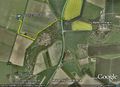
A deeply frozen field between Castle Acre and Lexham, north of Swaffham, Norfolk UK.
Participants
Expedition
Neil walked 1.1 km from the road to the hashpoint. The farm track was deeply frozen with no water under the puddles of ice. The hash was 55 metres from the vehicular access track. The field was frozen hard and the new crop had not yet been planted. It was about 19:35 and had been dark for three hours. The moon had not yet risen but the snow and ice reflected enough light to make a torch unnecessary. At the hashpoint, a few dim lights could be seen in the distance with naked winter trees and hedges closer by. Another 1.1 km back to the car. Neil forgot to change his footwear and did the 2.2 km in sandals. The re-frozen snow was cold and solid enough to not to stick to his socks so his feet stayed dry and warm.
Photo Gallery
Google Earth Track

Achievements
Sourcerer earned the Frozen Geohash Achievement
|
Expeditions and Plans
| 2010-12-26 | ||
|---|---|---|
| Auckland, New Zealand | JimmyNZ, Greenslime, Krintar | By Google maps it appears to be at the base of a street light in a median s... |
| Milwaukee, Wisconsin | Bassoon, Dedehawk, The9thPatriarch, Jessie | In a park on the shore of Lake Michigan in Sheboygan, Wisconsin. |
| Zürich, Switzerland | Danatar | in a small forest between Thayngen and Dörflingen, near Schaffhausen. Coun... |
| Cambridge, United Kingdom | Sourcerer | A deeply frozen field between Castle Acre and Lexham, north of Swaffham, No... |
| Malmö, Sweden | Llavids | Near Bjärsjölagård, outside Hörby, Skåne, Sweden. |
| Helsingborg, Sweden | Fasanen | In a field next to Haverdal golf course, Halland, Sweden |
Sourcerer's Expedition Links
2010-12-25_52_0 - 2010-12-26_52_0 - 2010-12-27_52_1 - KML file download of Sourcerer's expeditions for use with Google Earth.