2015-11-25 52 0
| Wed 25 Nov 2015 in Cambridge, UK: 52.2792589, 0.5843808 geohashing.info google osm bing/os kml crox |
Location
2) In a field between Cavenham and the A14, Suffolk, UK.
Participants
Plans
Expedition two of four spanning midnight - 2015-11-25 52 1 - 2015-11-25 52 0 - 2015-11-26 52 1 - 2010-03-31 52 1 Retro - ETA 22:35.
Expedition
- Arrived. -- Sourcerer (talk) @52.2792,.5844 22:26, 25 November 2015 (GMT)
In clear bright moonlight the expedition followed a public footpath for about half the route. On similar farm tracks but off the right of way, the distance dropped to 360 metres. A field perimeter track with game bird feeders led closer. The final approach was on tractor tracks which also served to get back to the farm track. A large flock of partridges took flight on my return walk. The round trip distance was 3.6 km. Very nice! I added the rights of way to OpenStreetMap.
About two kilometres away, clearly visible, there was some industrial scale farming going on with. This was probably sugar beet loading judging by the noises. The large beets make a fine drumming sound when tipped into an empty lorry. The sugar factory was 12 km away at Bury St. Edmunds.
Photos
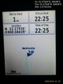
Proof. @52.2793,.5844
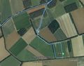
Google Earth Track


Achievements
Sourcerer earned the OpenStreetMap achievement
|
Expeditions and Plans
| 2015-11-25 | ||
|---|---|---|
| Cambridge, United Kingdom | Sourcerer | 2) In a field between Cavenham and the A14, Suffolk, UK. |
| Norwich, United Kingdom | Sourcerer | 1) In a field west of Dunwich, Suffolk, UK. |
| Bergen, Norway | Phi-loci-raptor, That creepy feeling you get off | Well... 500m off the road, not too far from home? I'd like to define a new ... |
Sourcerer's Expedition Links
2015-11-25 52 1 - 2015-11-25 52 0 - 2015-11-26 52 1 - KML file download of Sourcerer's expeditions for use with Google Earth.