2015-11-25 52 1
From Geohashing
| Wed 25 Nov 2015 in Norwich, UK: 52.2792589, 1.5843808 geohashing.info google osm bing/os kml crox |
Location
1) In a field west of Dunwich, Suffolk, UK.
Participants
Plans
Expedition one of four spanning midnight - 2015-11-25 52 1 - 2015-11-25 52 0 - 2015-11-26 52 1 - 2010-03-31 52 1 Retro - ETA 20:45.
Google Earth shows a pig farm but Street View shows a wheat field. We'll see.
Expedition
- Arrived -- Sourcerer (talk) @52.2793,1.5844 20:27, 25 November 2015 (GMT)
There was a parking place in front of a barn. The public footpath led in a non-ideal direction so the field perimeter parallel with the road was used. Later, tractor tracks led to the hashpoint in a field of winter wheat. The ground was quite soft and wet but not showing pools like the Google Earth view.
Photos
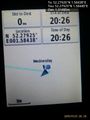
Proof. @52.2793,1.5844
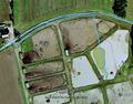
Google Earth Track


Achievements
Expeditions and Plans
| 2015-11-25 | ||
|---|---|---|
| Cambridge, United Kingdom | Sourcerer | 2) In a field between Cavenham and the A14, Suffolk, UK. |
| Norwich, United Kingdom | Sourcerer | 1) In a field west of Dunwich, Suffolk, UK. |
| Bergen, Norway | Phi-loci-raptor, That creepy feeling you get off | Well... 500m off the road, not too far from home? I'd like to define a new ... |
Sourcerer's Expedition Links
2015-11-24 52 0 - 2015-11-25 52 1 - 2015-11-25 52 0 - KML file download of Sourcerer's expeditions for use with Google Earth.