2021-02-06 45 4
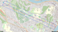
| Sat 6 Feb 2021 in 45,4: 45.7667093, 4.8028228 geohashing.info google osm bing/os kml crox |

Location
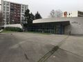
On a strip of lawn, next to a community centre in Lyon.
Participants
Plans
The location is 2 km from home. I will bicycle there in the afternoon.
And then go there by public transport.
And then walk run there.
Expedition
The geohash was located in Gorge de Loup, a district of Lyon, on the other side of the iconic Fourvière hill. There are 3 ways to go there. You can go around the hill, under the hill, or over the hill.
🚲 Around the hill
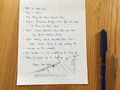
Cycling is my default mode of travel, so obviously I started with that. As I've been living in Lyon for 8 years and know the city relatively well, I decided to try the No Batteries Geohash achievement and turn my phone's location services off. To make sure that I wouldn't get lost, I wrote the turn-by-turn directions on a piece of paper with a sketch of the location.
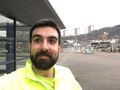
I walked to the nearest Vélo'v station (I haven't replaced my stolen bicycle yet) and temporarily re-enabled the location services so the app would let me pick a bicycle. Then Vélo'v 42013 and I went north along the Saône river and around the hill, entered Gorge de Loup and reached the coordinates at 13:55, after a 4 km ride.
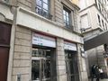
The geohash was located in the middle of a small strip of lawn, in front of a community centre (currently closed). After recording proof, we went back to the Vieux Lyon (Old Lyon) district and I bid farewell to Vélo'v 42013.
🚇 Under the hill
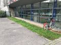
Vieux Lyon and Gorge de Loup are connected by the Metro D line that goes straight (kinda) through the hill. Perfect for a Juggernaut achievement. After a short stop at home, I walked to the Metro station, took a train and arrived at Gorge de Loup a couple of minutes later. I walked the remaining 200 meters to the geohash, reached the coordinates at 14:59 and recorded proof (again), then promptly returned back home, just in time to watch France beat Italy 50-10 in the Six Nations Championship.
I tried to record a GPX tracklog, but as expected I had no signal during most of the journey. So I had to rely on OpenStreetMap and my knowledge of the layout of the Vieux Lyon Metro station to draw the track. According to my calculations, my deviation ratio was about 1:26.
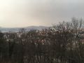
🏃♂️ Over the hill
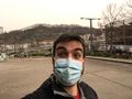
As Matthew Carley blew for the final whistle, there wasn't much time left before the start of the curfew. Not quite enough to walk to the geohash. But plenty enough to run there. So I put on my running shoes and started running up the hill until I reached the summit near the Basilica of Notre-Dame de Fourvière. Then I started running down the hill until I reached the coordinates at 17:43.
After recoding proof for the third time, I run to the Metro station and went back home.
🕐 Speedrun achievements
(Added on 2024-07-15)
All expeditions were completed in less than 60 minutes, though I can only prove it for one of them. The first and second expeditions took approximately 25 minutes each, but I don't have enough evidence to claim a Speedrun achievement for those.
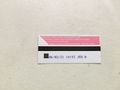
However, I have two photos that prove that the last expedition was completed in less than 47 minutes.
- The first photo is the photo of my metro ticket, which was taken in my apartment at 17:12, shortly before I left.
- The second photo shows me back in the building's hallway at 17:59. I originally took it to prove that I didn't violate the 18:00 curfew that existed at the time (because Covid).
Photos
Batteries not needed
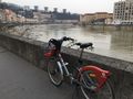
Vélo'v 42013 along the Saône
Vélo'v 42013 at the geohash
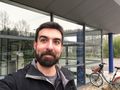
First stupid grin
Taking the Metro
Arriving at the geohash
Second stupid grin
Proof of travel
Juggernaut achievement confirmed
Above the hill
Third stupid grin
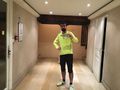
Back in 47 minutes


Achievements
Baarde earned the Land geohash achievement
|
Baarde earned the Bicycle geohash achievement
|
Baarde earned the Public transport geohash achievement
|
Baarde earned the Walk geohash Achievement
|
Baarde earned the Two to the N achievement
|
Baarde earned the No Batteries Geohash Achievement
|
Baarde earned the Juggernaut achievement
|
Baarde earned the Speedrun achievement
|
- Meetup on 2021-02-06
- Meetup in 45 4
- Land geohash achievement
- Bicycle geohash achievement
- Public transport geohash achievement
- Walk geohash achievement
- Two to the N achievement
- No batteries geohash achievement
- Juggernaut achievement
- Speedrun achievement
- Expeditions
- Expeditions with photos
- Coordinates reached
- Meetup in Métropole de Lyon