Difference between revisions of "2024-05-18 44 -124"
Michael5000 (talk | contribs) (→Location) |
m (subst-ing) |
||
| (6 intermediate revisions by 2 users not shown) | |||
| Line 8: | Line 8: | ||
And DON'T FORGET to add your expedition and the best photo you took to the gallery on the Main Page! We'd love to read your report, but that means we first have to discover it! :) | And DON'T FORGET to add your expedition and the best photo you took to the gallery on the Main Page! We'd love to read your report, but that means we first have to discover it! :) | ||
-->{{meetup graticule | -->{{meetup graticule | ||
| − | | lat= | + | | lat=44 |
| − | | lon= | + | | lon=-124 |
| − | | date= | + | | date=2024-05-18 |
}}<!-- edit as necessary --> | }}<!-- edit as necessary --> | ||
== Location == | == Location == | ||
| Line 16: | Line 16: | ||
== Participants == | == Participants == | ||
| − | + | *[[user:Michael5000|Michael5000]] | |
| − | |||
| − | == | + | == Expedition == |
| − | + | [[Image:2024-05-18 44 -124 f.jpg|200 px|left]] | |
| + | |||
| + | This hashpoint was only a few kilometers from Heceta Head, a landmark seen in a million generic calendar photos, so of course I took a picture for you. | ||
| + | |||
| + | A few minutes north, there's an attractive bridge over the imaginatively named "Big Creek." Immediately afterwards, I turned off Highway 101 on Big Creek Road, and drove in about a kilometer. | ||
| − | + | I was afraid that the 200 meters between the road and the hashpoint would be prohibitively steep and/or impenetrable, but although it was as steep as a staircase, it was quite open and easy to climb. It was surprisingly easy to get up on the ridge, after which it was a short walk to ground zero. | |
| − | |||
| − | + | Sometimes getting down is harder than climbing up, but that was actually pretty easy too, this time. I went back to the highway and continued my journey north. | |
| − | |||
== Photos == | == Photos == | ||
| Line 39: | Line 40: | ||
== Achievements == | == Achievements == | ||
{{#vardefine:ribbonwidth|100%}} | {{#vardefine:ribbonwidth|100%}} | ||
| − | |||
| − | + | *My first expedition to the elusive Newport graticule! | |
| − | + | ||
| − | + | {{Minesweeper geohash | |
| − | [[ | + | | graticule = [[Newport, Oregon]] |
| + | | ranknumber = 5 | ||
| + | | n = true | ||
| + | | ne = true if graticule to the northeast has been hashed (optional) | ||
| + | | e = true if graticule to the east has been hashed (optional) | ||
| + | | se = true if graticule to the southeast has been hashed (optional) | ||
| + | | s = true if graticule to the south has been hashed (optional) | ||
| + | | name = [[User:Michael5000|Michael5000]] | ||
| + | }} | ||
| + | |||
| + | |||
| + | {{Minesweeper geohash | ||
| + | | graticule = [[McMinnville, Oregon]] | ||
| + | | ranknumber = 8 | ||
| + | | n = true | ||
| + | | ne = true if graticule to the northeast has been hashed (optional) | ||
| + | | e = true if graticule to the east has been hashed (optional) | ||
| + | | se = true if graticule to the southeast has been hashed (optional) | ||
| + | | s = true if graticule to the south has been hashed (optional) | ||
| + | | sw = true if graticule to the southwest has been hashed (optional) | ||
| + | | w = true if graticule to the west has been hashed (optional) | ||
| + | | nw = true if graticule to the northwest has been hashed (optional) | ||
| + | | name = [[User:Michael5000|Michael5000]] | ||
| + | }} | ||
| + | |||
| + | {{Minesweeper geohash | ||
| + | | graticule = [[Eugene, Oregon]] | ||
| + | | ranknumber = 8 | ||
| + | | n = true | ||
| + | | ne = true if graticule to the northeast has been hashed (optional) | ||
| + | | e = true if graticule to the east has been hashed (optional) | ||
| + | | se = true if graticule to the southeast has been hashed (optional) | ||
| + | | s = true if graticule to the south has been hashed (optional) | ||
| + | | sw = true if graticule to the southwest has been hashed (optional) | ||
| + | | w = true if graticule to the west has been hashed (optional) | ||
| + | | nw = true if graticule to the northwest has been hashed (optional) | ||
| + | | name = [[User:Michael5000|Michael5000]] | ||
| + | }} | ||
| − | + | {{Minesweeper geohash | |
| − | + | | graticule = [[Roseburg, Oregon]] | |
| − | [[ | + | | ranknumber = 8 |
| − | + | | n = true | |
| + | | ne = true if graticule to the northeast has been hashed (optional) | ||
| + | | e = true if graticule to the east has been hashed (optional) | ||
| + | | se = true if graticule to the southeast has been hashed (optional) | ||
| + | | s = true if graticule to the south has been hashed (optional) | ||
| + | | sw = true if graticule to the southwest has been hashed (optional) | ||
| + | | w = true if graticule to the west has been hashed (optional) | ||
| + | | nw = true if graticule to the northwest has been hashed (optional) | ||
| + | | name = [[User:Michael5000|Michael5000]] | ||
| + | }} | ||
| − | + | {{Minesweeper geohash | |
| − | [[ | + | | graticule = [[Coos Bay, Oregon]] |
| − | + | | ranknumber = 5 | |
| − | + | | n = true | |
| − | [[ | + | | ne = true if graticule to the northeast has been hashed (optional) |
| − | + | | e = true if graticule to the east has been hashed (optional) | |
| + | | se = true if graticule to the southeast has been hashed (optional) | ||
| + | | s = true if graticule to the south has been hashed (optional) | ||
| + | | name = [[User:Michael5000|Michael5000]] | ||
| + | }} | ||
| − | + | {{Minesweeper geohash | |
| − | [[ | + | | graticule = [[North Lincoln City, Oregon]] |
| + | | ranknumber = 5 | ||
| + | | n = true | ||
| + | | ne = true if graticule to the northeast has been hashed (optional) | ||
| + | | e = true if graticule to the east has been hashed (optional) | ||
| + | | se = true if graticule to the southeast has been hashed (optional) | ||
| + | | s = true if graticule to the south has been hashed (optional) | ||
| + | | name = [[User:Michael5000|Michael5000]] | ||
| + | }} | ||
| − | |||
| − | |||
| − | |||
| − | |||
| − | |||
| − | |||
| − | |||
| − | |||
| − | |||
| − | + | __NOTOC__ | |
| + | [[Category:Expeditions]] | ||
| + | [[Category:Expeditions with photos]] | ||
| + | [[Category:Coordinates reached]] | ||
| + | {{location|US|OR|LE}} | ||
Latest revision as of 21:21, 24 May 2024
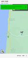
| Sat 18 May 2024 in 44,-124: 44.1728929, -124.0998813 geohashing.info google osm bing/os kml crox |
Location
On a ridge north of Big Creek Road, near Heceta Head.
Participants
Expedition

This hashpoint was only a few kilometers from Heceta Head, a landmark seen in a million generic calendar photos, so of course I took a picture for you.
A few minutes north, there's an attractive bridge over the imaginatively named "Big Creek." Immediately afterwards, I turned off Highway 101 on Big Creek Road, and drove in about a kilometer.
I was afraid that the 200 meters between the road and the hashpoint would be prohibitively steep and/or impenetrable, but although it was as steep as a staircase, it was quite open and easy to climb. It was surprisingly easy to get up on the ridge, after which it was a short walk to ground zero.
Sometimes getting down is harder than climbing up, but that was actually pretty easy too, this time. I went back to the highway and continued my journey north.
Photos
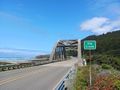
The bridge at Big Creek
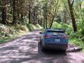
Big Creek Road
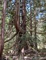
The hashpoint tree

Me


Achievements
- My first expedition to the elusive Newport graticule!
Michael5000 achieved level 5 of the Minesweeper Geohash achievement
|
Michael5000 completed the Minesweeper Geohash achievement
|
Michael5000 completed the Minesweeper Geohash achievement
|
Michael5000 completed the Minesweeper Geohash achievement
|
Michael5000 achieved level 5 of the Minesweeper Geohash achievement
|
Michael5000 achieved level 5 of the Minesweeper Geohash achievement
|