Difference between revisions of "2024-05-28 45 -122"
Michael5000 (talk | contribs) (→Photos) |
m (Location) |
||
| (6 intermediate revisions by one other user not shown) | |||
| Line 9: | Line 9: | ||
-->{{meetup graticule|date=2024-05-28|lat=45|lon=-122}} | -->{{meetup graticule|date=2024-05-28|lat=45|lon=-122}} | ||
== Location == | == Location == | ||
| − | + | In somebody's driveway in Lake Oswego. | |
== Participants == | == Participants == | ||
| − | + | *[[user:Michael5000|Michael5000]] | |
| − | |||
| − | |||
| − | |||
| − | |||
== Expedition == | == Expedition == | ||
| − | + | There aren't a lot of reasons to head out at the end of a gloomy workday to look at some tucked-away residential streets in the already tucked-away suburb of Lake Oswego. But then, that's kind of what geohashing is ''for'', as far as I'm concerned. | |
| − | + | It seemed like this hashpoint would be well positioned to start a run along the Willamette River, and it was, but it was also up an impressive hill, so the first kilometer or so was steeply downhill. I ran for about 2.5 miles, then ran back about 1.5 miles and then felt too tired to keep going. I felt kind of guilty about skipping the uphill part, though. | |
| − | |||
== Photos == | == Photos == | ||
<gallery perrow="5"> | <gallery perrow="5"> | ||
| − | File:2024-05-28 45 -122 a.jpg | + | File:2024-05-28 45 -122 a.jpg|The nearby intersection, where I parked |
| − | File:2024-05-28 45 -122 b.jpg | + | File:2024-05-28 45 -122 b.jpg|A nice forest path starts right by the hashpoint |
| − | File:2024-05-28 45 -122 c.jpg | + | File:2024-05-28 45 -122 c.jpg|The hashpoint itself is right by that mailbox |
File:2024-05-28 45 -122 d.jpg | File:2024-05-28 45 -122 d.jpg | ||
</gallery> | </gallery> | ||
| Line 34: | Line 29: | ||
== Achievements == | == Achievements == | ||
{{#vardefine:ribbonwidth|100%}} | {{#vardefine:ribbonwidth|100%}} | ||
| − | |||
| − | |||
| − | |||
| − | |||
| − | |||
| − | |||
| − | |||
| − | |||
| − | |||
| − | |||
| − | |||
| − | |||
| − | |||
[[Category:Expeditions]] | [[Category:Expeditions]] | ||
| − | |||
[[Category:Expeditions with photos]] | [[Category:Expeditions with photos]] | ||
| − | |||
| − | |||
| − | |||
| − | |||
[[Category:Coordinates reached]] | [[Category:Coordinates reached]] | ||
| − | + | {{location|US|OR|CC}} | |
| − | |||
| − | |||
| − | |||
| − | |||
| − | |||
| − | |||
| − | |||
| − | |||
| − | |||
| − | |||
| − | |||
| − | |||
| − | |||
Latest revision as of 04:42, 31 May 2024
| Tue 28 May 2024 in 45,-122: 45.4075038, -122.6639881 geohashing.info google osm bing/os kml crox |
Location
In somebody's driveway in Lake Oswego.
Participants
Expedition
There aren't a lot of reasons to head out at the end of a gloomy workday to look at some tucked-away residential streets in the already tucked-away suburb of Lake Oswego. But then, that's kind of what geohashing is for, as far as I'm concerned.
It seemed like this hashpoint would be well positioned to start a run along the Willamette River, and it was, but it was also up an impressive hill, so the first kilometer or so was steeply downhill. I ran for about 2.5 miles, then ran back about 1.5 miles and then felt too tired to keep going. I felt kind of guilty about skipping the uphill part, though.
Photos
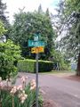
The nearby intersection, where I parked
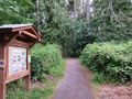
A nice forest path starts right by the hashpoint
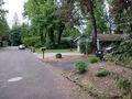
The hashpoint itself is right by that mailbox