Difference between revisions of "2024-06-14 48 8"
m (Location) |
m |
||
| (3 intermediate revisions by 2 users not shown) | |||
| Line 5: | Line 5: | ||
}} | }} | ||
== Location == | == Location == | ||
| − | In a | + | In a wood near [[wikipedia:Rœschwoog|Rœschwoog]]. |
== Participants == | == Participants == | ||
| Line 12: | Line 12: | ||
== Plans == | == Plans == | ||
[[User:Baarde|Baarde]] will take the train to Rountzenheim, then walk to the coordinates. He expects to arrive at 19:20. | [[User:Baarde|Baarde]] will take the train to Rountzenheim, then walk to the coordinates. He expects to arrive at 19:20. | ||
| + | |||
| + | == Expedition == | ||
| + | I initially intended to take the train to Rœschwoog. Instead I stopped at the previous station in Rountzenheim, which was slightly closer to the geohash. Not because I didn't want to walk a couple extra hundred meters, but because I wanted to avoid getting an unvolountary [[Camping geohash achievement]]. | ||
| + | |||
| + | I had only 45 minutes to walk 1500 meters to hashpoint, perform the geohash dance, record proof, walk back to the train station, and catch the last train to Strasbourg. 33 minutes once you account for the train delay and the wait at the level-crossing when exiting the station. I did it in 29 minutes. Of course all that haste was unnecessary as my return train arrived 50 minutes late. | ||
| + | |||
| + | == Photos == | ||
| + | <gallery> | ||
| + | File:2024-06-14 48 8 01.jpg | In Rountzenheim | ||
| + | File:2024-06-14 48 8 02.jpg | Walking to the coordinates | ||
| + | File:2024-06-14 48 8 03.jpg | Near the coordinates | ||
| + | File:2024-06-14 48 8 05.png | Coordinates reached | ||
| + | File:2024-06-14 48 8 04.jpg | Stupid grin | ||
| + | </gallery> | ||
| + | |||
| + | == Achievements == | ||
| + | {{#vardefine:ribbonwidth|100%}} | ||
| + | {{land geohash | ||
| + | | latitude = 48 | ||
| + | | longitude = 8 | ||
| + | | date = 2024-06-14 | ||
| + | | name = [[User:Baarde|Baarde]] | ||
| + | }} | ||
| + | {{Reverse Regional | ||
| + | | latitude = 48 | ||
| + | | longitude = 8 | ||
| + | | name = [[User:Baarde|Baarde]] | ||
| + | | count = 2 | ||
| + | | graticule = Pforzheim, Germany | ||
| + | | level = country | ||
| + | }} | ||
__NOTOC__ | __NOTOC__ | ||
[[Category:Expeditions]] | [[Category:Expeditions]] | ||
| + | [[Category:Expeditions with photos]] | ||
| + | [[Category:Coordinates reached]] | ||
{{location|FR|67}} | {{location|FR|67}} | ||
Latest revision as of 18:27, 17 June 2024
| Fri 14 Jun 2024 in 48,8: 48.8304534, 8.0095443 geohashing.info google osm bing/os kml crox |
Location
In a wood near Rœschwoog.
Participants
Plans
Baarde will take the train to Rountzenheim, then walk to the coordinates. He expects to arrive at 19:20.
Expedition
I initially intended to take the train to Rœschwoog. Instead I stopped at the previous station in Rountzenheim, which was slightly closer to the geohash. Not because I didn't want to walk a couple extra hundred meters, but because I wanted to avoid getting an unvolountary Camping geohash achievement.
I had only 45 minutes to walk 1500 meters to hashpoint, perform the geohash dance, record proof, walk back to the train station, and catch the last train to Strasbourg. 33 minutes once you account for the train delay and the wait at the level-crossing when exiting the station. I did it in 29 minutes. Of course all that haste was unnecessary as my return train arrived 50 minutes late.
Photos
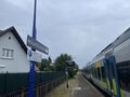
In Rountzenheim
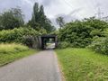
Walking to the coordinates
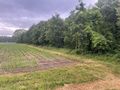
Near the coordinates
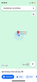
Coordinates reached
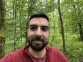
Stupid grin


Achievements
Baarde earned the Land geohash achievement
|
Baarde earned the Reverse regional achievement
|