Difference between revisions of "2024-06-29 49 8"
Green guy! (talk | contribs) (Add gallery and update categories) |
m (Location) |
||
| (6 intermediate revisions by one other user not shown) | |||
| Line 1: | Line 1: | ||
| − | <!-- Title image | + | <!-- Title image --> |
| − | + | [[File:OMIMG_20240629_113804.jpg|300px|thumb|right]] | |
<!-- And DON'T FORGET to add your expedition and the best photo you took to the gallery on the Main Page! We'd love to read your report, but that means we first have to discover it! :) --> | <!-- And DON'T FORGET to add your expedition and the best photo you took to the gallery on the Main Page! We'd love to read your report, but that means we first have to discover it! :) --> | ||
| Line 9: | Line 9: | ||
}} | }} | ||
== Location == | == Location == | ||
| − | |||
In a forest area, about 60 meters away from the closest path (according to OpenStreetMap), in Darmstadt-Dieburg county, Hesse, Germany. The closest built-up area is the commercial park of Weiterstadt in south direction, over the ''Rhein-Main'' railway. | In a forest area, about 60 meters away from the closest path (according to OpenStreetMap), in Darmstadt-Dieburg county, Hesse, Germany. The closest built-up area is the commercial park of Weiterstadt in south direction, over the ''Rhein-Main'' railway. | ||
| − | This day’s weather | + | This day’s weather: sunny with a few clouds, warm, getting really hot and sticky in the course of the day |
== Participants == | == Participants == | ||
| Line 27: | Line 26: | ||
== Expedition == | == Expedition == | ||
<!-- a 10-to-50-word text is sufficient! --> | <!-- a 10-to-50-word text is sufficient! --> | ||
| − | + | As planned, before it got too hot, a few minutes after 11 am, my parents and I drove to the parking lot next to the ''Wasserwerk'' (water works). After parking our car, we crossed the secondary road ''<span style="padding-right: 0.2em">L</span>3113'' and looked for a way to reach the coordinates. We tried the path at the small residential area, but it turned out to be driveway to private property with a locked gate to prevent trespassing. | |
| − | + | With that knowledge, we walked back south and entered the forest from the roadside to then intricately make our way through the thicket. However, the shrubs were too dense at the location of our first attempt, so we tried again further south. Starting from there, it took a while to reach the coordinates, but we ultimately made it to the hashpoint and also managed to return safely to the roadside afterwards (except for a few ticks and minor scratches). | |
| − | == Tracklog: Walking to the hashpoint | + | Back at our car, we decided to walk a little more by going south from the ''Wasserwerk'' and coming back. |
| − | + | ||
| − | + | Overall, it was a really adventurous expedition, according to my standard at this time. My parents stated that they never walked through a forest thicket like this one before and that I would be keeping them young (by taking them with me on such trips). | |
| − | * I | + | |
| − | + | Back at home, my mom checked everyone for ticks – she found two on my body which were trivial to remove (as they didn’t have much time). As this expedition worked up a sweat on all of us and because the weather is hot, we took refreshing showers. | |
| − | * GPS accuracy: | + | |
| − | * Markers show all locations where I took photos | + | == Tracklog: Walking to the hashpoint == |
| − | + | * I started the tracklog in the car near Weiterstadt and stopped it when coming back to the car after the expedition. | |
| − | + | * GPS accuracy: medium | |
| + | * Markers show all locations where I took photos – a few of them are taken for OpenStreetMap surveying. | ||
| + | {{Tracklog|GH 2024-06-29 49 8 at 11-09.gpx}} | ||
== Pictures == | == Pictures == | ||
| − | < | + | === Initial plan === |
| − | + | <gallery> | |
| + | File:OMIMG_20240629_111412.jpg | Our car, parked next to … | ||
| + | File:OMIMG_20240629_111439.jpg | … the ''Wasserwerk'' (water works) | ||
| + | File:OMIMG_20240629_111602.jpg | Roadside walking north (the road is off-screen to the right) | ||
| + | File:OMIMG_20240629_111629.jpg | Initially considered “path” to approach the hashpoint … but no trespassing! | ||
| + | </gallery> | ||
| + | === Going into the forest === | ||
<gallery> | <gallery> | ||
| − | + | File:OMIMG_20240629_111742.jpg | Roadside walking back south | |
| − | + | File:OMIMG_20240629_111859.jpg | First attempt to enter the forest | |
| − | |||
| − | |||
| − | File:OMIMG_20240629_111742.jpg | ||
| − | File:OMIMG_20240629_111859.jpg | ||
File:OMIMG_20240629_112339.jpg | File:OMIMG_20240629_112339.jpg | ||
| − | File:OMIMG_20240629_112635.jpg | + | File:OMIMG_20240629_112635.jpg | Second attempt with a lot of shrubs to go through at first … |
| − | File:OMIMG_20240629_112759.jpg | + | File:OMIMG_20240629_112759.jpg | … but we made it in! |
File:OMIMG_20240629_113010.jpg | File:OMIMG_20240629_113010.jpg | ||
| − | File:OMIMG_20240629_113053.jpg | + | File:OMIMG_20240629_113053.jpg | Cobwebs on the grass which look like cotton candy |
File:OMIMG_20240629_113314.jpg | File:OMIMG_20240629_113314.jpg | ||
File:OMIMG_20240629_113537.jpg | File:OMIMG_20240629_113537.jpg | ||
| − | File:OMIMG_20240629_113628.jpg | + | File:OMIMG_20240629_113628.jpg | Someone was here before and left plastic lying around … Why didn’t it occur to me to [[Geotrash Geohash|pick it up]]? Probably because I dislike getting my hands dirty … |
| − | File:OMIMG_20240629_113720.jpg | + | File:OMIMG_20240629_113720.jpg | Getting close |
| − | File:Screenshot_20240629-113759_OruxMaps.png | + | </gallery> |
| − | File:OMIMG_20240629_113804.jpg | + | === Hashsite amid trees === |
| − | File:OMIMG_20240629_113817.jpg | + | <gallery> |
| − | File:OMIMG_20240629_114013.jpg | + | File:Screenshot_20240629-113759_OruxMaps.png | Coordinates reached! |
| + | File:OMIMG_20240629_113804.jpg | Looking east from the hashpoint | ||
| + | File:OMIMG_20240629_113817.jpg | Grinning at the camera | ||
| + | </gallery> | ||
| + | === Leaving the forest === | ||
| + | <gallery> | ||
| + | File:OMIMG_20240629_114013.jpg | Going back | ||
File:OMIMG_20240629_114426.jpg | File:OMIMG_20240629_114426.jpg | ||
| − | File:OMIMG_20240629_115104.jpg | + | File:OMIMG_20240629_115104.jpg | Back at our car |
| − | File:OMIMG_20240629_115200.jpg | + | </gallery> |
| − | File:OMIMG_20240629_115303.jpg | + | === Overtime === |
| − | File:OMIMG_20240629_115415.jpg | + | <gallery> |
| − | File:OMIMG_20240629_115433.jpg | + | File:OMIMG_20240629_115200.jpg | We decided to keep walking a little longer by going on this track road. |
| + | File:OMIMG_20240629_115303.jpg | Another way (branching off the first one) which is not in <abbr title="OpenStreetMap">OSM</abbr> before my changeset | ||
| + | File:OMIMG_20240629_115415.jpg | Bumblebee at the flowers | ||
| + | File:OMIMG_20240629_115433.jpg | Some kind of gage or valve related to the water works | ||
File:OMIMG_20240629_115456.jpg | File:OMIMG_20240629_115456.jpg | ||
| − | File:OMIMG_20240629_115524.jpg | + | File:OMIMG_20240629_115524.jpg | And another one |
File:OMIMG_20240629_115554.jpg | File:OMIMG_20240629_115554.jpg | ||
File:OMIMG_20240629_115632.jpg | File:OMIMG_20240629_115632.jpg | ||
| Line 81: | Line 93: | ||
I earned these for the first time from this geohash. | I earned these for the first time from this geohash. | ||
{{#vardefine:ribbonwidth|100%}} | {{#vardefine:ribbonwidth|100%}} | ||
| − | + | {{Two to the N achievement | |
| count = 3 | | count = 3 | ||
| latitude = {{#explode:{{SUBPAGENAME}}| |1}} | | latitude = {{#explode:{{SUBPAGENAME}}| |1}} | ||
| Line 88: | Line 100: | ||
| name = [[User:Green guy!|Green guy!]] ([[User talk:Green guy!|talk]]) | | name = [[User:Green guy!|Green guy!]] ([[User talk:Green guy!|talk]]) | ||
| reached = true | | reached = true | ||
| − | }} -- | + | }} |
| + | {{gratuitous ribbon | ||
| + | | color = #440 | ||
| + | | icon = Tick_by_Lorc_Game-icons.net_color_-444400.svg | ||
| + | | latitude = {{#explode:{{SUBPAGENAME}}| |1}} | ||
| + | | longitude = {{#explode:{{SUBPAGENAME}}| |2}} | ||
| + | | date = {{#explode:{{SUBPAGENAME}}| |0}} | ||
| + | | achievement = Thicket Ticks Achievement | ||
| + | | description = catching ticks in the thicket (and removing them later before they sucked blood) for the | ||
| + | | name = [[User:Green guy!|Green guy!]] ([[User talk:Green guy!|talk]]) | ||
| + | }} | ||
=== Recurring === | === Recurring === | ||
I already earned these from an earlier geohash, but fulfilled the conditions again on this one. | I already earned these from an earlier geohash, but fulfilled the conditions again on this one. | ||
{{#vardefine:ribbonwidth|100%}} | {{#vardefine:ribbonwidth|100%}} | ||
| − | + | {{OpenStreetMap achievement | |
| latitude = {{#explode:{{SUBPAGENAME}}| |1}} | | latitude = {{#explode:{{SUBPAGENAME}}| |1}} | ||
| longitude = {{#explode:{{SUBPAGENAME}}| |2}} | | longitude = {{#explode:{{SUBPAGENAME}}| |2}} | ||
| date = {{#explode:{{SUBPAGENAME}}| |0}} | | date = {{#explode:{{SUBPAGENAME}}| |0}} | ||
| − | | OSMlink = | + | | OSMlink = 153419793 |
| − | |||
| − | |||
| name = [[User:Green guy!|Green guy!]] ([[User talk:Green guy!|talk]]) | | name = [[User:Green guy!|Green guy!]] ([[User talk:Green guy!|talk]]) | ||
| − | }} | + | }} |
| − | + | {{land geohash | |
| latitude = {{#explode:{{SUBPAGENAME}}| |1}} | | latitude = {{#explode:{{SUBPAGENAME}}| |1}} | ||
| longitude = {{#explode:{{SUBPAGENAME}}| |2}} | | longitude = {{#explode:{{SUBPAGENAME}}| |2}} | ||
| date = {{#explode:{{SUBPAGENAME}}| |0}} | | date = {{#explode:{{SUBPAGENAME}}| |0}} | ||
| name = [[User:Green guy!|Green guy!]] ([[User talk:Green guy!|talk]]) | | name = [[User:Green guy!|Green guy!]] ([[User talk:Green guy!|talk]]) | ||
| − | }} | + | }} |
__NOTOC__ | __NOTOC__ | ||
| − | |||
| − | |||
| − | |||
| − | |||
| − | |||
| − | |||
[[Category:Expeditions]] | [[Category:Expeditions]] | ||
| Line 120: | Line 134: | ||
[[Category:Coordinates reached]] | [[Category:Coordinates reached]] | ||
| + | {{location|DE|HE|DA}} | ||
Latest revision as of 16:42, 1 July 2024

| Sat 29 Jun 2024 in 49,8: 49.9030150, 8.6133894 geohashing.info google osm bing/os kml crox |
Location
In a forest area, about 60 meters away from the closest path (according to OpenStreetMap), in Darmstadt-Dieburg county, Hesse, Germany. The closest built-up area is the commercial park of Weiterstadt in south direction, over the Rhein-Main railway.
This day’s weather: sunny with a few clouds, warm, getting really hot and sticky in the course of the day
Participants
- Green guy! (talk)
- Green guy!’s mother (no consent to publish photos of her)
- Green guy!’s father (no consent to publish photos of him)
Plans
- Drive near the geohash before it gets too hot and sticky! (likely around 11 am)
- Park our car next to the Wasserwerk (water works)
- Go on a forest walk to visit the hashpoint
- Drive back home
Expedition
As planned, before it got too hot, a few minutes after 11 am, my parents and I drove to the parking lot next to the Wasserwerk (water works). After parking our car, we crossed the secondary road L3113 and looked for a way to reach the coordinates. We tried the path at the small residential area, but it turned out to be driveway to private property with a locked gate to prevent trespassing.
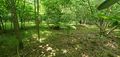
With that knowledge, we walked back south and entered the forest from the roadside to then intricately make our way through the thicket. However, the shrubs were too dense at the location of our first attempt, so we tried again further south. Starting from there, it took a while to reach the coordinates, but we ultimately made it to the hashpoint and also managed to return safely to the roadside afterwards (except for a few ticks and minor scratches).
Back at our car, we decided to walk a little more by going south from the Wasserwerk and coming back.
Overall, it was a really adventurous expedition, according to my standard at this time. My parents stated that they never walked through a forest thicket like this one before and that I would be keeping them young (by taking them with me on such trips).
Back at home, my mom checked everyone for ticks – she found two on my body which were trivial to remove (as they didn’t have much time). As this expedition worked up a sweat on all of us and because the weather is hot, we took refreshing showers.
Tracklog: Walking to the hashpoint
- I started the tracklog in the car near Weiterstadt and stopped it when coming back to the car after the expedition.
- GPS accuracy: medium
- Markers show all locations where I took photos – a few of them are taken for OpenStreetMap surveying.
Pictures
Initial plan
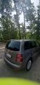
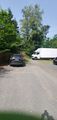
Our car, parked next to …
… the Wasserwerk (water works)
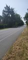
Roadside walking north (the road is off-screen to the right)
Initially considered “path” to approach the hashpoint … but no trespassing!


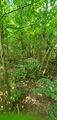
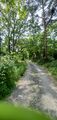
Going into the forest
Roadside walking back south
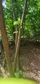
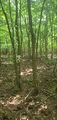
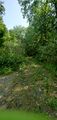
First attempt to enter the forest
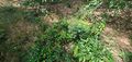
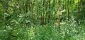
Second attempt with a lot of shrubs to go through at first …
… but we made it in!
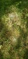
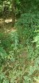
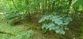
Cobwebs on the grass which look like cotton candy
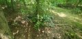
Someone was here before and left plastic lying around … Why didn’t it occur to me to pick it up? Probably because I dislike getting my hands dirty …
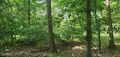
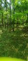
Getting close


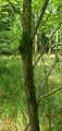
Hashsite amid trees
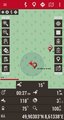
Coordinates reached!
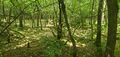
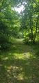
Looking east from the hashpoint

Grinning at the camera


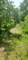
Leaving the forest
Going back
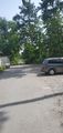
Back at our car


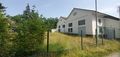
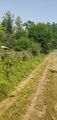
Overtime
We decided to keep walking a little longer by going on this track road.
Another way (branching off the first one) which is not in OSM before my changeset
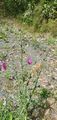
Bumblebee at the flowers
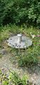
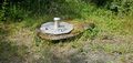
Some kind of gage or valve related to the water works
And another one


Achievements
First-time
I earned these for the first time from this geohash.

Green guy! (talk) earned the Thicket Ticks Achievement
|
Recurring
I already earned these from an earlier geohash, but fulfilled the conditions again on this one.
Green guy! (talk) earned the OpenStreetMap achievement
|
Green guy! (talk) earned the Land geohash achievement
|