Difference between revisions of "2009-08-13 52 13"
imported>Lyx (→Tracklog) |
imported>Relet m |
||
| Line 39: | Line 39: | ||
davidc's approximate route: [http://maps.google.co.uk/maps?f=d&source=s_d&saddr=Rosenthaler+Platz&daddr=Chausseestra%C3%9Fe+to:Pankstra%C3%9Fe+to:Emmentaler+Str.+to:Unknown+road+to:Unknown+road+to:Kienhorststra%C3%9Fe+43,+Reinickendorf+13403+Berlin,+Germany+to:Lienemannstra%C3%9Fe+to:General-Barby-Stra%C3%9Fe+to:Kienhorststra%C3%9Fe+to:Ollenhauerstra%C3%9Fe+to:Charles-Corcelle-Ring+to:Unknown+road+to:Am+Nordhafen+to:Gartenstra%C3%9Fe+to:52.530556,13.391261+to:Rosenthaler+Platz&hl=en&geocode=FSSLIQMdC3zMAA%3BFSiIIQMdlDzMAA%3BFSHWIQMdMhzMAA%3BFbcmIgMdndfLAA%3BFS4mIgMdIpTLAA%3BFYgvIgMd5onLAA%3BFXQ1IgMdimXLAA%3BFQg-IgMdEUzLAA%3BFSUxIgMdsTnLAA%3BFdM2IgMdFEjLAA%3BFRQuIgMd2GjLAA%3BFTj-IQMd-1XLAA%3BFQDbIQMd5DvLAA%3BFeeoIQMdu-3LAA%3BFZurIQMdmTDMAA%3B%3BFSSLIQMdC3zMAA&mra=dpe&mrcr=1&mrsp=15&sz=15&via=1,2,3,4,5,7,8,9,10,11,12,13,14,15&dirflg=w&sll=52.530765,13.393364&sspn=0.016761,0.034633&ie=UTF8&z=15 google maps] (24km)<br/> | davidc's approximate route: [http://maps.google.co.uk/maps?f=d&source=s_d&saddr=Rosenthaler+Platz&daddr=Chausseestra%C3%9Fe+to:Pankstra%C3%9Fe+to:Emmentaler+Str.+to:Unknown+road+to:Unknown+road+to:Kienhorststra%C3%9Fe+43,+Reinickendorf+13403+Berlin,+Germany+to:Lienemannstra%C3%9Fe+to:General-Barby-Stra%C3%9Fe+to:Kienhorststra%C3%9Fe+to:Ollenhauerstra%C3%9Fe+to:Charles-Corcelle-Ring+to:Unknown+road+to:Am+Nordhafen+to:Gartenstra%C3%9Fe+to:52.530556,13.391261+to:Rosenthaler+Platz&hl=en&geocode=FSSLIQMdC3zMAA%3BFSiIIQMdlDzMAA%3BFSHWIQMdMhzMAA%3BFbcmIgMdndfLAA%3BFS4mIgMdIpTLAA%3BFYgvIgMd5onLAA%3BFXQ1IgMdimXLAA%3BFQg-IgMdEUzLAA%3BFSUxIgMdsTnLAA%3BFdM2IgMdFEjLAA%3BFRQuIgMd2GjLAA%3BFTj-IQMd-1XLAA%3BFQDbIQMd5DvLAA%3BFeeoIQMdu-3LAA%3BFZurIQMdmTDMAA%3B%3BFSSLIQMdC3zMAA&mra=dpe&mrcr=1&mrsp=15&sz=15&via=1,2,3,4,5,7,8,9,10,11,12,13,14,15&dirflg=w&sll=52.530765,13.393364&sspn=0.016761,0.034633&ie=UTF8&z=15 google maps] (24km)<br/> | ||
lyx's approximate route: [http://maps.google.co.uk/maps?f=d&source=s_d&saddr=52.53361,13.347015&daddr=Sylter+Str.+to:Dohnagestell+to:Unknown+road+to:Unknown+road+to:Ollenhauerstra%C3%9Fe+to:Kienhorststra%C3%9Fe+43,+Reinickendorf+13403+Berlin,+Germany&geocode=%3BFbC4IQMdF4PLAA%3BFdbIIQMdAHDLAA%3BFZrNIQMd2m3LAA%3BFcjlIQMd1FDLAA%3BFVo1IgMdbmvLAA%3BFXQ1IgMdimXLAA&hl=en&mra=dme&mrcr=0&mrsp=0&sz=14&via=1,2,3,4,5&dirflg=w&sll=52.538727,13.3459&sspn=0.024014,0.055189&ie=UTF8&z=14 google maps] (6km (one way)) | lyx's approximate route: [http://maps.google.co.uk/maps?f=d&source=s_d&saddr=52.53361,13.347015&daddr=Sylter+Str.+to:Dohnagestell+to:Unknown+road+to:Unknown+road+to:Ollenhauerstra%C3%9Fe+to:Kienhorststra%C3%9Fe+43,+Reinickendorf+13403+Berlin,+Germany&geocode=%3BFbC4IQMdF4PLAA%3BFdbIIQMdAHDLAA%3BFZrNIQMd2m3LAA%3BFcjlIQMd1FDLAA%3BFVo1IgMdbmvLAA%3BFXQ1IgMdimXLAA&hl=en&mra=dme&mrcr=0&mrsp=0&sz=14&via=1,2,3,4,5&dirflg=w&sll=52.538727,13.3459&sspn=0.024014,0.055189&ie=UTF8&z=14 google maps] (6km (one way)) | ||
| + | |||
| + | Google maps is unable to display relet's and pari's route accurately, as it does not know the correct footpaths we took. | ||
== Photos == | == Photos == | ||
Revision as of 21:51, 13 August 2009
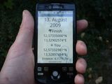
| Thu 13 Aug 2009 in 52,13: 52.5733500, 13.3290257 geohashing.info google osm bing/os kml crox |
Location
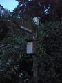
Behind a Bohle building in an industrial site on Kienhorststraße.
Right next by is the Museum Staatliche Münze. Opens Mo - Fr 10.00 - 16.00 Uhr.
Participants
Plans
If we are to visit the museum (free entry), I would suggest to meet in the morning, 9-10am. It will be difficult for me to get there before 4pm otherwise.
If not, 7pm sounds like a plan. :)-- relet 13:38, 12 August 2009 (UTC)
I approve 7pm. Museum would be nice, too. But I don't have time before 1pm.
Do you go by bike, too? Where do you want to meet? --pari 15:11, 12 August 2009 (UTC)
I would. Probably starting at Goslarer Platz directly, via Westhafen. -- relet 16:58, 12 August 2009 (UTC)
- ETA Goslarer Platz: 18:40! -- relet 13:15, 13 August 2009 (UTC)
Probable hash collision! http://coord.info/GCY864 --Davidc
I am going to walk! (5.9km from my home) ETA 19:15, hope to see you! lyxi-büxi (not-logged-in lyx)
Expedition
live from the expedition
- davidc found the cache with the first grab. -- relet 17:24, 13 August 2009 (UTC)
- picture selection seems to fail. have to check if it's user fail or script fail. -- relet 18:18, 13 August 2009 (UTC)
Geocaches found: GCY864 (hash collision), GC1HA8Z, GCTK25 and GC1404F.
relet
Tracklog
davidc's approximate route: google maps (24km)
lyx's approximate route: google maps (6km (one way))
Google maps is unable to display relet's and pari's route accurately, as it does not know the correct footpaths we took.
Photos
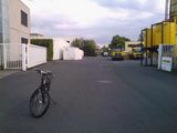
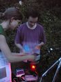
This picture tells you that relet is ready to rumble. He just spent two days coding image upload and live messaging for the geohashdroid.
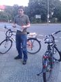
ready to go (picture thumbnail still does not update for me)
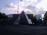
the museum
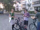
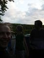
met lyx and davidc. yay!

Huggy Bear and Lost visit the State Mint Museum
hash collision honorable mention. wasn't the criterion "line of sight"?
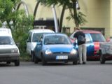
Phoenix came by car

bohle company was hosting today's hash.
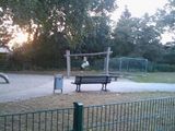
12 meters - a fence!

First silly grin shot, 12m from the hashpoint. phoenix, pari, lyx, relet, davidc, rabbitfox
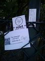
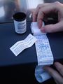
left our cards at 12m.

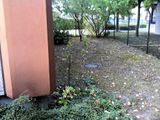
The hashpoint was behind a fence, we thought this was as close as we could get.
someone at the gate! ambassador and coordinates reached!
relet runs over to play ambassador
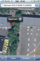
Map Screenshot
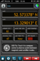
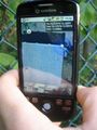
GPS Screenshot

relet strikes towards the hashpoint
It did say three-something just before I triggered the release.
What a silly grin group shot looks when three people pull out their cameras at the same time.

Silly grin "group" shot, 2nd POV
The hashpoint from behind
orderly retreat
this is how we train for Vancouver.

hammocks!
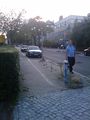
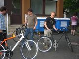
More caching on the way back
A nice hiding spot for a cache - ekorren will recognize it.


