Difference between revisions of "2009-08-18 52 13"
From Geohashing
(→Participants) |
imported>Relet |
||
| Line 1: | Line 1: | ||
| − | + | {{meetup graticule | |
| lat=52 | | lat=52 | ||
| lon=13 | | lon=13 | ||
| Line 57: | Line 57: | ||
| − | |||
| − | |||
| − | |||
| − | |||
| − | |||
| − | |||
[[Category:Expeditions]] | [[Category:Expeditions]] | ||
| − | |||
[[Category:Expeditions with photos]] | [[Category:Expeditions with photos]] | ||
| − | |||
| − | |||
| − | |||
| − | |||
| − | |||
[[Category:Coordinates reached]] | [[Category:Coordinates reached]] | ||
| − | |||
| − | |||
| − | |||
| − | |||
| − | |||
| − | |||
| − | |||
| − | |||
| − | |||
| − | |||
| − | |||
Revision as of 20:16, 18 August 2009
| Tue 18 Aug 2009 in 52,13: 52.6759309, 13.2043881 geohashing.info google osm bing/os kml crox |
Location
Near the Velten channel, between Hennigsdorf and Velten, in the forests.
Participants
Plans
- relet: Bring the long slackline. Go swimming and slacking! :D I'll probably go by car to carry my gear - in that case there will be seats available. -- relet 14:21, 17 August 2009 (UTC)
- update: Phoenix grautitousl^Wgrateful^Wkindly offered his car. -- relet 15:15, 17 August 2009 (UTC)
- pari: maybe going by bike and getting back to Berlin city limit before sunset, that means leaving the meetup point by 19:30 CEST at the latest. gonna wait for detailed plans from you guys :) --pari 20:53, 17 August 2009 (UTC)
Expedition
- yay. we built the line. we just did not manage to slack that far. -- relet 19:10, 18 August 2009 (UTC)
Tracklog
Photos
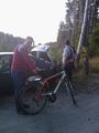
244m to go.
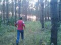
in the woods.
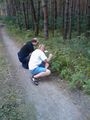
back from the coordinates. they found playthings.
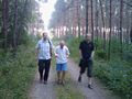
more photos: the approach through the woods.


