Difference between revisions of "2009-08-18 52 13"
imported>Pari (→Plans) |
imported>FippeBot m (Location) |
||
| (14 intermediate revisions by 4 users not shown) | |||
| Line 1: | Line 1: | ||
| − | |||
| − | |||
| − | |||
| − | |||
{{meetup graticule | {{meetup graticule | ||
| lat=52 | | lat=52 | ||
| Line 13: | Line 9: | ||
== Location == | == Location == | ||
| − | Near the Velten channel, between Hennigsdorf and Velten, in the forests. | + | Near the Velten channel, between Hennigsdorf and Velten, in the forests. |
| − | |||
* http://de.wikipedia.org/wiki/Veltener_Stichkanal | * http://de.wikipedia.org/wiki/Veltener_Stichkanal | ||
| Line 21: | Line 16: | ||
* [[User:relet|relet]] | * [[User:relet|relet]] | ||
* [[User:Phoenix|Phoenix]] | * [[User:Phoenix|Phoenix]] | ||
| − | * [[User:lyx|lyx]] | + | * [[User:lyx|<s>lyx</s>]] |
* knispel | * knispel | ||
* Joti | * Joti | ||
| − | * [[User:pari|pari]] | + | * [[User:pari|pari]] |
== Plans == | == Plans == | ||
| Line 37: | Line 32: | ||
| + | |||
| + | *yay. we built the line. we just did not manage to slack that far. -- [[User:relet|relet]] 19:10, 18 August 2009 (UTC) | ||
== Tracklog == | == Tracklog == | ||
| Line 48: | Line 45: | ||
--> | --> | ||
<gallery perrow="3"> | <gallery perrow="3"> | ||
| + | |||
| + | |||
| + | Image:2009-08-18_52_13_19-03-55-083.jpg | 244m to go. | ||
| + | |||
| + | Image:2009-08-18_52_13_22-08-46-937.jpg | the approach through the woods. | ||
| + | |||
| + | Image:2009-08-18_52_13_DSCF1372.JPG | Into the woods. | ||
| + | |||
| + | Image:2009-08-18_52_13_19-16-21-113.jpg | in the woods. | ||
| + | |||
| + | Image:2009-08-18_52_13_DSCF1374.JPG | Sort of a proof. Accuracy messed up our GPS dance once again - but it was all woods anyway. | ||
| + | |||
| + | Image:2009-08-18_52_13_DSCF1377.JPG | Three for a stupid grin. | ||
| + | |||
| + | Image:2009-08-18_52_13_19-20-36-619.jpg | back from the coordinates. The others found playthings. | ||
| + | |||
| + | Image:2009-08-18_19.24.49.jpg | The Velten channel | ||
| + | |||
| + | Image:2009-08-18_19.39.49.jpg | We got a boats! | ||
| + | |||
| + | Image:2009-08-18_52_13_DSCF1379.JPG | And a ropes! | ||
| + | |||
| + | Image:2009-08-18_19.40.04.jpg | Protecting the trees. | ||
| + | |||
| + | Image:2009-08-18_19.44.27.jpg | A lever block for pulling | ||
| + | |||
| + | Image:2009-08-18_19.51.52.jpg | How the line reaches the other side | ||
| + | |||
| + | Image:2009-08-18_19.53.30.jpg | Capt'n Joti and knispel, rowing. The former got the role of captain, after failing at rowing. | ||
| + | |||
| + | Image:2009-08-18_19.55.43.jpg | Success! | ||
| + | |||
| + | Image:2009-08-18_52_13_DSCF1381.JPG | knispel landing | ||
| + | |||
| + | Image:2009-08-18_52_13_DSCF1382.JPG | OM NOM NOM! | ||
| + | |||
| + | Image:2009-08-18_52_13_DSCF1385.JPG | Pulling is faster that rowing. | ||
| + | |||
| + | Image:2009-08-18_52_13_DSCF1391.JPG | relet, ratcheting | ||
| + | |||
| + | Image:2009-08-18_52_13_DSCF1392.JPG | knispel, ratcheting | ||
| + | |||
| + | Image:2009-08-18_52_13_DSCF1393.JPG | Whoa - that's a bit higher than we thought. | ||
| + | |||
| + | Image:2009-08-18_52_13_DSCF1394.JPG | relet passes the rowing test. | ||
| + | |||
| + | Image:2009-08-18_52_13_DSCF1397.JPG | Erm.. just testing the flex. Really. | ||
</gallery> | </gallery> | ||
| + | And now where you would expect to see us walking, there is only a big nothingness. Partly, because the wet rope was too heavy - so that we did not get further than ten to twenty steps. Partly, because the photographers were on the other side of the channel. Partly, because it got dark. :P | ||
| − | |||
| − | |||
| − | |||
| − | |||
| − | |||
| − | |||
[[Category:Expeditions]] | [[Category:Expeditions]] | ||
| − | |||
[[Category:Expeditions with photos]] | [[Category:Expeditions with photos]] | ||
| − | |||
| − | |||
| − | |||
| − | |||
| − | |||
[[Category:Coordinates reached]] | [[Category:Coordinates reached]] | ||
| − | + | {{location|DE|BB|OHV}} | |
| − | |||
| − | |||
| − | |||
| − | |||
| − | |||
| − | |||
| − | |||
| − | |||
| − | |||
Latest revision as of 05:15, 8 August 2019
| Tue 18 Aug 2009 in 52,13: 52.6759309, 13.2043881 geohashing.info google osm bing/os kml crox |
Location
Near the Velten channel, between Hennigsdorf and Velten, in the forests.
Participants
Plans
- relet: Bring the long slackline. Go swimming and slacking! :D I'll probably go by car to carry my gear - in that case there will be seats available. -- relet 14:21, 17 August 2009 (UTC)
- update: Phoenix grautitousl^Wgrateful^Wkindly offered his car. -- relet 15:15, 17 August 2009 (UTC)
- pari: maybe going by bike and getting back to Berlin city limit before sunset, that means leaving the meetup point by 19:30 CEST at the latest. gonna wait for detailed plans from you guys :) --pari 20:53, 17 August 2009 (UTC)
Expedition
- yay. we built the line. we just did not manage to slack that far. -- relet 19:10, 18 August 2009 (UTC)
Tracklog
Photos

244m to go.

the approach through the woods.

Into the woods.

in the woods.

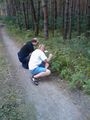
Sort of a proof. Accuracy messed up our GPS dance once again - but it was all woods anyway.

Three for a stupid grin.
back from the coordinates. The others found playthings.
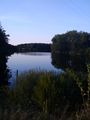
The Velten channel

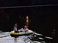
We got a boats!

And a ropes!

Protecting the trees.

A lever block for pulling

How the line reaches the other side
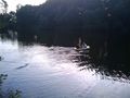
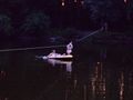
Capt'n Joti and knispel, rowing. The former got the role of captain, after failing at rowing.
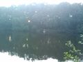
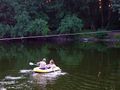
Success!

knispel landing

OM NOM NOM!

Pulling is faster that rowing.
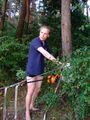
relet, ratcheting
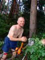
knispel, ratcheting
Whoa - that's a bit higher than we thought.
relet passes the rowing test.
Erm.. just testing the flex. Really.


And now where you would expect to see us walking, there is only a big nothingness. Partly, because the wet rope was too heavy - so that we did not get further than ten to twenty steps. Partly, because the photographers were on the other side of the channel. Partly, because it got dark. :P