Difference between revisions of "2010-09-12 52 1"
imported>Sourcerer |
imported>Sourcerer |
||
| Line 1: | Line 1: | ||
| − | |||
| − | |||
| − | |||
| − | |||
{{meetup graticule | {{meetup graticule | ||
| lat=52 | | lat=52 | ||
| Line 8: | Line 4: | ||
| date=2010-09-12 | | date=2010-09-12 | ||
| graticule_name=Norwich | | graticule_name=Norwich | ||
| − | | graticule_link=Norwich, United Kingdom}} | + | | graticule_link=Norwich, United Kingdom |
| + | }} | ||
| + | |||
| + | == Location == | ||
| + | |||
| + | In light rough on the Halesworth Golf Course. | ||
== Participants == | == Participants == | ||
| Line 22: | Line 23: | ||
== Image Gallery == | == Image Gallery == | ||
| − | <gallery | + | <gallery> |
Image:2010-09-12_52_1_Sourcerer_GE.jpg|Google Earth with Expedition Path. | Image:2010-09-12_52_1_Sourcerer_GE.jpg|Google Earth with Expedition Path. | ||
Image:2010-09-12_52_1_Sourcerer_GE_Zoom.jpg|Google Earth Expedition Path at the Hashpoint. | Image:2010-09-12_52_1_Sourcerer_GE_Zoom.jpg|Google Earth Expedition Path at the Hashpoint. | ||
| Line 31: | Line 32: | ||
{{expedition summaries|2010-09-12}} | {{expedition summaries|2010-09-12}} | ||
| − | |||
| − | |||
[[Category:Expeditions]] | [[Category:Expeditions]] | ||
[[Category:Coordinates reached]] | [[Category:Coordinates reached]] | ||
[[Category:Expeditions with photos]] | [[Category:Expeditions with photos]] | ||
Revision as of 14:45, 22 August 2012
| Sun 12 Sep 2010 in Norwich: 52.3299831, 1.5132765 geohashing.info google osm bing/os kml crox |
Contents
Location
In light rough on the Halesworth Golf Course.
Participants
Expedition
Sourcerer, Neil chased the setting sickle moon into the west as the daylight slowly faded. There was a small layby about 300 metres from the hashpoint and a disused road led in the right direction. Bats were flying and owls could be heard in the distance. A short walk into the golf course led past a green and across the fairway into light rough. The club house was a few hundred metres away and looked welcoming. The course was deserted because it was nearly dark. The GPS receiver distance-to-destination measurement dropped to 1 metre. Neil walked in a small circle but the distance never went below 1 metre. The evening calm was shattered by sirens. It was the railway level crossing. A three car diesel multiple unit train was labouring up hill heading towards Halesworth and Beccles.
This expedition had a bit more spice than usual because, unusually, the Google Earth view was covered in cloud. There was a greater element of surprise. Tomorrow's hash is interesting too. It's in the grounds of Banham Zoo and perhaps the hashpoint is in a tiger enclosure. Sadly, Neil has to work and will not find out.
Image Gallery
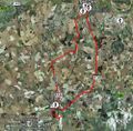
Google Earth with Expedition Path.
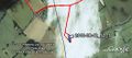
Google Earth Expedition Path at the Hashpoint.


Other geohashing expeditions on the same day
Expeditions and Plans
| 2010-09-12 | ||
|---|---|---|
| Baltimore, Maryland | Mike | Rosedale, just off of 95, just East of the Rosedale Shopping Center. It app... |
| Andorra la Vella, Andorra | relet | The bridge of Ortedó, or very close to it. |
| Perpignan, France | relet | Just south of the southernmost tip of France. |
| München, Germany | Zb | On a hill near Amperpettenbach. |
| Norwich, United Kingdom | Sourcerer | In light rough on the Halesworth Golf Course. |