Difference between revisions of "2012-01-07 52 1"
imported>Sourcerer ([live] Arrived.) |
imported>Sourcerer |
||
| Line 1: | Line 1: | ||
| − | |||
| − | |||
| − | |||
| − | |||
| − | |||
| − | |||
| − | |||
| − | |||
| − | |||
| − | |||
{{meetup graticule | {{meetup graticule | ||
| − | | lat=52 | + | | lat=52 |
| − | | lon=1 | + | | lon=1 |
| − | | date=2012-01-07 | + | | date=2012-01-07 |
| + | | graticule_name=Norwich | ||
| + | | graticule_link=Norwich, United Kingdom | ||
}} | }} | ||
| − | |||
| − | |||
== Location == | == Location == | ||
| − | + | ||
| + | In the boundary hedge of a private house on Loddon Road, Ditchingham overlooking Broom Common near Bungay, Norfolk, UK logged at [http://en.wikiloc.com/wikiloc/view.do?id=2373202 wikiloc]. | ||
== Participants == | == Participants == | ||
| − | |||
| − | + | * [[User:Sourcerer | Sourcerer]] | |
| − | |||
== Expedition == | == Expedition == | ||
| − | |||
| + | Neil's droid said ... | ||
*Arrived. -- [[User:Sourcerer|Sourcerer]] [http://www.openstreetmap.org/?lat=52.47037589550018&lon=1.449320912361145&zoom=16&layers=B000FTF @52.4704,1.4493] 13:39, 07 January 2012 (GMT) | *Arrived. -- [[User:Sourcerer|Sourcerer]] [http://www.openstreetmap.org/?lat=52.47037589550018&lon=1.449320912361145&zoom=16&layers=B000FTF @52.4704,1.4493] 13:39, 07 January 2012 (GMT) | ||
| − | + | ||
| − | + | After months of laziness and good food, Neil's new year's resolution was to get more exercise and lose a bit of weight. This walk of over 12 miles or almost 23 km was a step in the right direction although the three pubs on the return route, although most welcome for resting the feet and warming up, probably undid most of the good. There are some fine ales in Norfolk. The Waveney valley was flooded so the preferred route home was blocked. Neil took a longer route, mostly on quiet lanes. | |
== Photos == | == Photos == | ||
| − | < | + | |
| − | Image: | + | <gallery perrow="3"> |
| − | -- | + | Image:2012-01-07_52_1_Sourcerer_00.jpg|Tracklog |
| − | + | Image:2012-01-07_52_1_Sourcerer_0.jpg|Tracklog Close Up | |
| + | Image:2012-01-07_52_1_Sourcerer_01.jpg|Fallen tree blocking the path | ||
| + | Image:2012-01-07_52_1_Sourcerer_02.jpg|One of the footpaths | ||
| + | Image:2012-01-07_52_1_Sourcerer_03.jpg|Mill and Maltings on the route | ||
| + | Image:2012-01-07_52_1_Sourcerer_04.jpg|Waveney Weir | ||
| + | Image:2012-01-07_52_1_Sourcerer_05.jpg|Mill and Maltings on the route | ||
| + | Image:2012-01-07_52_1_Sourcerer_06.jpg|Another Waveney Weir | ||
| + | Image:2012-01-07_52_1_Sourcerer_07.jpg|Broom Common | ||
| + | Image:2012-01-07_52_1_Sourcerer_08.jpg|The Haspoint House | ||
| + | Image:2012-01-07_52_1_Sourcerer_09.jpg|Broom Common | ||
| + | Image:2012-01-07_52_1_Sourcerer_10.jpg|The Artichoke Pub | ||
| + | Image:2012-01-07_52_1_Sourcerer_11.jpg|Moonrise | ||
| + | Image:2012-01-07_52_1_Sourcerer_12.jpg|Flooded Waveney Valley | ||
| + | Image:2012-01-07_52_1_Sourcerer_13.jpg|Flooded Waveney Valley Sunset | ||
| + | Image:2012-01-07_52_1_Sourcerer_14.jpg|Flooded Waveney Valley | ||
</gallery> | </gallery> | ||
== Achievements == | == Achievements == | ||
| − | |||
| − | |||
| + | {{Walk geohash | ||
| + | | latitude = 52 | ||
| + | | longitude = 1 | ||
| + | | date = 2012-01-07 | ||
| + | | name = Sourcerer | ||
| + | | distance = 22.8 km | ||
| + | }} | ||
| − | + | {{Tron | |
| − | + | | latitude = 52 | |
| − | + | | longitude = 1 | |
| + | | date = 2012-01-05 | ||
| + | | tracklog = http://en.wikiloc.com/wikiloc/view.do?id=2373186 | ||
| + | | possessive = his | ||
| + | | name = Sourcerer | ||
| + | }} | ||
| − | + | == Other geohashing expeditions on the same day == | |
| − | |||
| − | |||
| − | |||
| − | + | {{expedition summaries|2012-01-07}} | |
| + | |||
| + | [[Category:Meetup on 2012-01-07]] | ||
| + | [[Category:Meetup in 52 1]] | ||
[[Category:Expeditions]] | [[Category:Expeditions]] | ||
| − | |||
[[Category:Expeditions with photos]] | [[Category:Expeditions with photos]] | ||
| − | |||
| − | |||
| − | |||
| − | |||
| − | |||
[[Category:Coordinates reached]] | [[Category:Coordinates reached]] | ||
| − | |||
| − | |||
| − | |||
| − | |||
| − | |||
| − | |||
| − | |||
| − | |||
| − | |||
| − | |||
Revision as of 07:37, 8 January 2012
| Sat 7 Jan 2012 in Norwich: 52.4703656, 1.4493502 geohashing.info google osm bing/os kml crox |
Contents
Location
In the boundary hedge of a private house on Loddon Road, Ditchingham overlooking Broom Common near Bungay, Norfolk, UK logged at wikiloc.
Participants
Expedition
Neil's droid said ...
- Arrived. -- Sourcerer @52.4704,1.4493 13:39, 07 January 2012 (GMT)
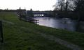
After months of laziness and good food, Neil's new year's resolution was to get more exercise and lose a bit of weight. This walk of over 12 miles or almost 23 km was a step in the right direction although the three pubs on the return route, although most welcome for resting the feet and warming up, probably undid most of the good. There are some fine ales in Norfolk. The Waveney valley was flooded so the preferred route home was blocked. Neil took a longer route, mostly on quiet lanes.
Photos
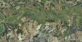
Tracklog
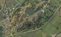
Tracklog Close Up
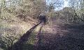
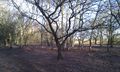
Fallen tree blocking the path
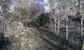
One of the footpaths
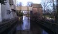
Mill and Maltings on the route
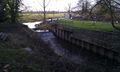
Waveney Weir
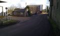
Mill and Maltings on the route
Another Waveney Weir
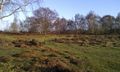
Broom Common

The Haspoint House
Broom Common
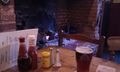
The Artichoke Pub
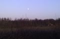
Moonrise
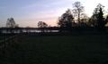
Flooded Waveney Valley
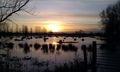
Flooded Waveney Valley Sunset
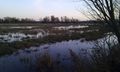
Flooded Waveney Valley


Achievements
Sourcerer earned the Walk geohash Achievement
|
Sourcerer earned the Tron achievement
|
Other geohashing expeditions on the same day
Expeditions and Plans
| 2012-01-07 | ||
|---|---|---|
| Pakenham, Australia | Felix Dance | In a field off the Bass Highway near Coronet Bay |
| Aurora, Illinois | EvilUncleNomo, The Wife | In a field in Newark, Illinois, U.S.A. It looks like some kind of a quarry ... |
| Portland, Oregon | Jim, kydlt, Michael5000 | In the middle of Butler Road, Southwest of Portland. |
| Thunder Bay, Ontario | User:Jack1254 | About 400m past the end of Nicholettes Rd in Oliver Paipoonge, ON. |
| Mannheim, Germany | ilpadre | In a park in Ludwigshafen. |
| Norwich, United Kingdom | Sourcerer | In the boundary hedge of a private house on Loddon Road, Ditchingham overlo... |
| Sheffield, United Kingdom | Monty | Nr. Hood Hill Farm, Hood Hill, Wentworth, ?Barnsley? (Very close to Sheffi... |