Difference between revisions of "2013-02-18 52 0"
From Geohashing
imported>Sourcerer m ([live] Arrived at third of four planned points.) |
imported>Sourcerer (→Sourcerer New Expedition) |
||
| Line 1: | Line 1: | ||
| − | |||
| − | |||
| − | |||
| − | |||
| − | |||
| − | |||
| − | |||
| − | |||
| − | |||
| − | |||
{{meetup graticule | {{meetup graticule | ||
| − | | lat=52 | + | | lat=52 |
| − | | lon=0 | + | | lon=0 |
| − | | date=2013-02-18 | + | | date=2013-02-18 |
| + | | graticule_name=Cambridge | ||
| + | | graticule_link=Cambridge, United Kingdom | ||
}} | }} | ||
| − | |||
| − | |||
== Location == | == Location == | ||
| − | + | ||
| + | North of the Mildenhall Air Base, Suffolk, UK. | ||
== Participants == | == Participants == | ||
| − | |||
| − | |||
| − | + | [[User:Sourcerer|Sourcerer]] | |
| − | |||
== Expedition == | == Expedition == | ||
| − | |||
| + | *Arrived at the third of four planned points. -- [[User:Sourcerer|Sourcerer]] [http://www.openstreetmap.org/?lat=52.37506628036499&lon=0.4949212074279785&zoom=16&layers=B000FTF @52.3751,.4949] 14:16, 18 February 2013 (GMT) | ||
| − | + | This was attempt three of four on this day. The hashpoint was on the boundary between two agricultural fields. It might have been a pub geohash but the pub looked closed. For some reason, I got quite disorientated and set off in the wrong direction twice before zeroing in on the true point. The route to this hashpoint included a part of Thetford forest. This is a very nice place to visit. | |
| − | |||
| − | |||
== Photos == | == Photos == | ||
| − | + | ||
| − | |||
| − | |||
<gallery perrow="5"> | <gallery perrow="5"> | ||
| + | Image:2013-02-18_52_0_Sourcerer.jpg|The Hashpoint | ||
</gallery> | </gallery> | ||
| − | == | + | == Other geohashing expeditions on the same day == |
| − | |||
| − | |||
| − | |||
| − | + | {{expedition summaries|2013-02-18}} | |
| − | |||
| − | |||
| − | |||
| − | |||
| − | |||
| − | |||
| − | |||
| − | |||
[[Category:Expeditions]] | [[Category:Expeditions]] | ||
| − | |||
[[Category:Expeditions with photos]] | [[Category:Expeditions with photos]] | ||
| − | |||
| − | |||
| − | |||
| − | |||
| − | |||
[[Category:Coordinates reached]] | [[Category:Coordinates reached]] | ||
| − | |||
| − | |||
| − | |||
| − | |||
| − | |||
| − | |||
| − | |||
| − | |||
| − | |||
| − | |||
| − | |||
| − | |||
| − | |||
| − | |||
| − | |||
| − | |||
| − | |||
| − | |||
Revision as of 07:50, 19 February 2013
| Mon 18 Feb 2013 in Cambridge: 52.3750652, 0.4949735 geohashing.info google osm bing/os kml crox |
Contents
Location
North of the Mildenhall Air Base, Suffolk, UK.
Participants
Expedition
- Arrived at the third of four planned points. -- Sourcerer @52.3751,.4949 14:16, 18 February 2013 (GMT)
This was attempt three of four on this day. The hashpoint was on the boundary between two agricultural fields. It might have been a pub geohash but the pub looked closed. For some reason, I got quite disorientated and set off in the wrong direction twice before zeroing in on the true point. The route to this hashpoint included a part of Thetford forest. This is a very nice place to visit.
Photos
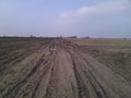
The Hashpoint

Other geohashing expeditions on the same day
Expeditions and Plans
| 2013-02-18 | ||
|---|---|---|
| Zürich, Switzerland | Calamus | The Albisrieden district in Zurich. |
| Northampton, United Kingdom | Sourcerer | 2) Failed to reach agricultural land south of the A14 near Thrapston. |
| Birmingham, United Kingdom | Sourcerer | 1) An area of heath and wood surrounded by major roads and a small river, C... |
| Cambridge, United Kingdom | Sourcerer, Benjw | 3) North of the Mildenhall Air Base, Suffolk, UK. |
| Norwich, United Kingdom | Sourcerer | 4) In a field of winter wheat, close to Spexhall, Halesworth, Suffolk, UK. |