Difference between revisions of "2013-02-18 52 0"
imported>Sourcerer m ([live] Arrived at third of four planned points.) |
imported>FippeBot m (Location) |
||
| (6 intermediate revisions by 2 users not shown) | |||
| Line 1: | Line 1: | ||
| − | |||
| − | |||
| − | |||
| − | |||
| − | |||
| − | |||
| − | |||
| − | |||
| − | |||
| − | |||
{{meetup graticule | {{meetup graticule | ||
| − | | lat=52 | + | | lat=52 |
| − | | lon=0 | + | | lon=0 |
| − | | date=2013-02-18 | + | | date=2013-02-18 |
| + | | graticule_name=Cambridge | ||
| + | | graticule_link=Cambridge, United Kingdom | ||
}} | }} | ||
| − | |||
| − | |||
== Location == | == Location == | ||
| − | + | ||
| + | 3) North of the Mildenhall Air Base, Suffolk, UK. | ||
== Participants == | == Participants == | ||
| − | |||
| − | |||
| − | + | * [[User:Sourcerer|Sourcerer]] | |
| − | + | * [[User:Benjw|Benjw]] | |
== Expedition == | == Expedition == | ||
| − | |||
| + | === Sourcerer === | ||
| + | *Arrived at the third of four planned points. -- [[User:Sourcerer|Sourcerer]] [http://www.openstreetmap.org/?lat=52.37506628036499&lon=0.4949212074279785&zoom=16&layers=B000FTF @52.3751,.4949] 14:16, 18 February 2013 (GMT) | ||
| + | |||
| + | [[2013-02-18 52 -1]] :: [[2013-02-18 52 -0]] :: [[2013-02-18 52 0]] :: [[2013-02-18 52 1]] | ||
| + | |||
| + | This was attempt three of four on this day. The hashpoint was on the boundary between two agricultural fields. It might have been a pub geohash but the pub looked closed. For some reason, I got quite disorientated and set off in the wrong direction twice before zeroing in on the true point. The route to this hashpoint included a part of Thetford forest. This is a very nice place to visit. | ||
| − | + | === Benjw === | |
| − | + | Ben was unaware that Sourcerer was also attempting this hashpoint today, but in any case had to be there much later because of work. Ben set off from Cambridge mid-afternoon, visiting a few nearby geocaches on the way, and then parking in the nearby village and walking the short but very muddy distance along the edge of the field to the hashpoint, where he arrived just after 5pm. He took some photos of the area and of the sun setting, and then went home to make dinner. It was a nice afternoon out. | |
| − | |||
== Photos == | == Photos == | ||
| − | + | ||
| − | |||
| − | |||
<gallery perrow="5"> | <gallery perrow="5"> | ||
| + | Image:2013-02-18_52_0_Sourcerer.jpg|The Hashpoint (Sourcerer) | ||
| + | Image:2013-02-18_52_0_river1.jpg|Eriswell Lode | ||
| + | Image:2013-02-18_52_0_river2.jpg|Eriswell Lode again | ||
| + | Image:2013-02-18_52_0_swan.jpg|A swan on the lode | ||
| + | Image:2013-02-18_52_0_hashpoint.jpg|The hashpoint (Benjw) | ||
| + | Image:2013-02-18_52_0_gps.jpg|Proof of hash | ||
| + | Image:2013-02-18_52_0_benjw.jpg|Happy hasher | ||
| + | Image:2013-02-18_52_0_village.jpg|The village next to the hashpoint | ||
| + | Image:2013-02-18_52_0_sunset.jpg|Sunset from the hashpoint | ||
</gallery> | </gallery> | ||
| − | + | {{Sourcerer_links | |
| − | {{ | + | | prev = 2013-02-18 52 -0 |
| − | + | | curr = 2013-02-18 52 0 | |
| − | + | | next = 2013-02-18 52 1 | |
| − | + | | date = 2013-02-18 | |
| − | + | }} | |
| − | |||
| − | |||
| − | |||
| − | |||
| − | |||
| − | |||
| − | |||
| − | |||
[[Category:Expeditions]] | [[Category:Expeditions]] | ||
| − | |||
[[Category:Expeditions with photos]] | [[Category:Expeditions with photos]] | ||
| − | |||
| − | |||
| − | |||
| − | |||
| − | |||
[[Category:Coordinates reached]] | [[Category:Coordinates reached]] | ||
| − | + | {{location|GB|ENG|SFK}} | |
| − | |||
| − | |||
| − | |||
| − | |||
| − | |||
| − | |||
| − | |||
| − | |||
| − | |||
| − | |||
| − | |||
| − | |||
| − | |||
| − | |||
| − | |||
| − | |||
| − | |||
Latest revision as of 01:01, 14 August 2019
| Mon 18 Feb 2013 in Cambridge: 52.3750652, 0.4949735 geohashing.info google osm bing/os kml crox |
Contents
Location
3) North of the Mildenhall Air Base, Suffolk, UK.
Participants
Expedition
Sourcerer
- Arrived at the third of four planned points. -- Sourcerer @52.3751,.4949 14:16, 18 February 2013 (GMT)
2013-02-18 52 -1 :: 2013-02-18 52 -0 :: 2013-02-18 52 0 :: 2013-02-18 52 1
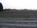
This was attempt three of four on this day. The hashpoint was on the boundary between two agricultural fields. It might have been a pub geohash but the pub looked closed. For some reason, I got quite disorientated and set off in the wrong direction twice before zeroing in on the true point. The route to this hashpoint included a part of Thetford forest. This is a very nice place to visit.
Benjw
Ben was unaware that Sourcerer was also attempting this hashpoint today, but in any case had to be there much later because of work. Ben set off from Cambridge mid-afternoon, visiting a few nearby geocaches on the way, and then parking in the nearby village and walking the short but very muddy distance along the edge of the field to the hashpoint, where he arrived just after 5pm. He took some photos of the area and of the sun setting, and then went home to make dinner. It was a nice afternoon out.
Photos
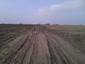
The Hashpoint (Sourcerer)
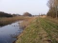
Eriswell Lode
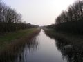
Eriswell Lode again
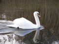
A swan on the lode
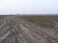
The hashpoint (Benjw)
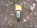
Proof of hash
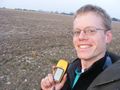
Happy hasher
The village next to the hashpoint
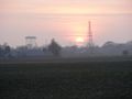
Sunset from the hashpoint


Expeditions and Plans
| 2013-02-18 | ||
|---|---|---|
| Zürich, Switzerland | Calamus | The Albisrieden district in Zurich. |
| Northampton, United Kingdom | Sourcerer | 2) Failed to reach agricultural land south of the A14 near Thrapston. |
| Birmingham, United Kingdom | Sourcerer | 1) An area of heath and wood surrounded by major roads and a small river, C... |
| Cambridge, United Kingdom | Sourcerer, Benjw | 3) North of the Mildenhall Air Base, Suffolk, UK. |
| Norwich, United Kingdom | Sourcerer | 4) In a field of winter wheat, close to Spexhall, Halesworth, Suffolk, UK. |
Sourcerer's Expedition Links
2013-02-18 52 -0 - 2013-02-18 52 0 - 2013-02-18 52 1 - KML file download of Sourcerer's expeditions for use with Google Earth.