Difference between revisions of "2013-05-27 52 -2"
imported>Sourcerer m (→Added link to today's expeditions) |
imported>Sourcerer m (→Links) |
||
| Line 48: | Line 48: | ||
</gallery> | </gallery> | ||
| − | == | + | {{Sourcerer_links |
| − | + | | prev = 2013-04-28 52 1 | |
| − | + | | curr = 2013-05-27 52 -2 | |
| + | | next = 2013-06-02 52 1 | ||
| + | | date = 2013-04-28 | ||
| + | }} | ||
[[Category:Expeditions]] | [[Category:Expeditions]] | ||
[[Category:Expeditions with photos]] | [[Category:Expeditions with photos]] | ||
[[Category:Coordinates reached]] | [[Category:Coordinates reached]] | ||
Revision as of 12:15, 25 June 2015
| Mon 27 May 2013 in 52,-2: 52.9264759, -2.4123964 geohashing.info google osm bing/os kml crox |
Contents
Location
A field of frisky cows not far off the A53 from Market Drayton to Newcastle under Lyme, Staffordshire UK.
Participants
Sourcerer plus drag-along friends Will and Will of Beer and Curry fame.
Expedition
There was a folk music, beer and cider festival in Newcastle under Lyme competing with the geohash but Sourcerer (Neil) managed to drag Will and Will to the hashpoint. This was in a field of cows. The livestock only became visible after reaching the crest of the small hill. Neil was not too phased. Only one or two people are killed by cows each year and almost always there was a pet dog involved in the incident. Lacking a dog the risk was negligible so Neil happily logged the message below while Mike and Jane were fleeing the approaching cows. The cows never bothered to complete their approach as Neil totally ignored them. They lost interest.
At the folk music and beer festival there was a black beer called "Dark Arts". This was most delicious and with 6% alcohol it didn't take much to greatly improve the mood of the day, Some of the music was excellent and it was a pleasing afternoon without too many ill effects afterwards.
- Arrived. -- Sourcerer (talk) @52.9265,-2.4124 12:52, 27 May 2013 (GMT+01:00)
Achievements
Sourcerer earned the Drag-along achievement
|
Sourcerer earned the OpenStreetMap achievement
|
Expedition Gallery
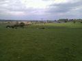
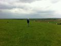
The Hashpoint
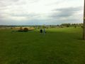
Sourcerer uploading to the wiki.
Sourcerer and Will
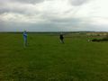
Will, Sourcerer and the Cows


Expeditions and Plans
| 2013-04-28 | ||
|---|---|---|
| Ballarat, Australia | Snaplatitude, a McDonalds Employee | A private paddock in Lexton |
| Springfield, Massachusetts | Todd | A quarter mile into a forest off Harris St/Harris Mountain Rd in Granby nea... |
| Houghton, Michigan | Someone went | On the Keweenaw peninsula. |
| Innsbruck, Austria | LeslieHapablap, EleanorAbernathy, Waltraud | On a meadow in the middle of the village Thaur, opposite to the priest's of... |
| Frankfurt am Main, Germany | QuarterCacher, LadyBB, EmmJay, Mampfred | On a little strip of grass near Schmitten. Better known as "in the pampa". |
| London West, United Kingdom | KennethCC | A muddied rut at the side of a narrow country lane outside Ockham in Surrey... |
| Leipzig, Germany | Bazaruto | Small wood near Holzhausen. |
| Eindhoven, Netherlands | Wythnir | In the bushes next to a small road near Schaft. |
| Birmingham, United Kingdom | Bollerenshaws | In a farmer's field north-east of Offchurch near Leamington Spa, UK. |
| Norwich, United Kingdom | Sourcerer | 500 metres east of the water tower near Sibton Green, Suffolk, UK. |
| Amsterdam, Netherlands | Murfie, Palmpje | Langevelderslag, The Netherlands |
| Karlskoga, Sweden | the ru, Thomas | In a forest just outside Karlskoga. |
Sourcerer's Expedition Links
2013-04-28 52 1 - 2013-05-27 52 -2 - 2013-06-02 52 1 - KML file download of Sourcerer's expeditions for use with Google Earth.