Difference between revisions of "2015-01-30 52 1"
imported>Sourcerer (An expedition message sent via Geohash Droid for Android.) |
imported>FippeBot m (Location) |
||
| (15 intermediate revisions by one other user not shown) | |||
| Line 1: | Line 1: | ||
| − | |||
| − | |||
| − | |||
| − | |||
| − | |||
| − | |||
| − | |||
| − | |||
| − | |||
| − | |||
{{meetup graticule | {{meetup graticule | ||
| lat=52 | | lat=52 | ||
| lon=1 | | lon=1 | ||
| date=2015-01-30 | | date=2015-01-30 | ||
| + | | graticule_name=Norwich, UK | ||
| + | | graticule_link=Norwich, United Kingdom | ||
}} | }} | ||
| − | |||
| − | |||
__NOTOC__ | __NOTOC__ | ||
== Location == | == Location == | ||
| − | + | ||
| + | In a field close to a public footpath north east of Wilby, Suffolk, UK. | ||
== Participants == | == Participants == | ||
| − | |||
| − | |||
| − | + | * [[User:Sourcerer|Sourcerer]] | |
| − | + | * [[User:ChromeCrusaders|ChromeCrusaders]] | |
== Expedition == | == Expedition == | ||
| − | |||
| − | == | + | === ChromeCrusaders - First Expedition === |
| − | + | ||
| + | The "Chrome Crusaders" is obviously more than one person, however that other person's motorcycle decided to break down after about two roads of leaving the house. So I decided to go alone. After following my SatNav to what I believed to be the location I parked my bike and walked over to the field. I didn't walk on the field because it had been laid with fresh manure. Little did I know that not only was this the wrong field, but that my phone GPS works without data... Who Knew! But my SatNav actually took me to the wrong place, because it is one decimal to inaccurate. | ||
| + | |||
| + | But all was well and no problems. The SatNav took me back a slightly different way to the way I came, along a narrow road called Mill Lane (or somewhere close to it). After going up a small incline I was faced with what can only be described as a steep decline into hell. At the bottom of this decline was a right hand turn. Ahead was a very very muddy farm entrance. I used my rear brake to slow down at the top of the hill... About halfway down my brain calculated that I wasn't going slow enough, more back brake... Back wheel loses traction on the ice that I didn't see, I reach the end of the tarmac and do the only thing I can do to save myself from the imminent metal gate. I pull the front brake. This in turn made me and the bike majestically fall onto the left hand side, covering us both in mud. | ||
| + | |||
| + | You never realise how heavy a bike is until its on its side and I must say, I was close to not being able to pick it up, it was dark so I couldn't see anything and motorcycle lights run of the engine power - which cuts out if the bike leans over to far. And the farm entrance was the slippy-est mud known to man. Fortunately it was just mud, and my bike still worked. But most importantly, no one saw. | ||
| + | |||
| + | I continued home after my first ever crash only to look at my fuel gauge which was just above the red... after telling my bike that its already F***ed me over once today, it decided that there was enough fuel to carry me home - Phew! | ||
| + | |||
| + | Lessons learned - and achievements gained! - No actual progress made but the next one should be easy... | ||
| + | |||
| + | === Sourcerer === | ||
| + | *Arrived. -- [[User:Sourcerer|Sourcerer]] ([[User talk:Sourcerer|talk]]) [http://www.openstreetmap.org/?lat=52.30548441&lon=1.28947735&zoom=16&layers=B000FTF @52.3055,1.2895] 11:05, 30 January 2015 (GMT) | ||
| + | |||
| + | This was 25km from home and easily reached on roads covered in a mixture of water, mud and ice. There was dry parking right by the start of the public footpath. The hashpoint was about 470 metres away. There were a couple of icy footbridges to add a bit of danger and excitement. Close to the hashpoint, the path was on the wrong side of a deep wet drainage ditch with a mature hedge of hawthorn, blackthorn and dog rose thorn - all impenetrable without a machete which I prefer not to carry! | ||
| + | |||
| + | About 130 metres further along the path there was a place to cross the ditch and there was a gap in the hedge. The ditch was nearly two metres deep and the only safe way down was a back side slide resulting in a muddy bum and nettle stings on the palms of my hands. The things we to for our sport! | ||
| + | |||
| + | An easy backtrack took me to the hashpoint for photos and message posting. Then the whole walk was done in reverse without further incident but quite a lot more mud. | ||
| + | |||
| + | I was not aware that ChromeCrusaders planned to go later that day, in the dark, in poor weather and with no previous experience. It's interesting to see the steep learning curve of new geohashers. Welcome! | ||
== Photos == | == Photos == | ||
| − | + | ||
| − | |||
| − | |||
<gallery perrow="5"> | <gallery perrow="5"> | ||
| + | Image:2015-01-30 52 1 Sourcerer 0.jpg | Track reconstruction | ||
| + | Image:2015-01-30 52 1 Sourcerer 1.jpg | Proof | ||
| + | Image:2015-01-30 52 1 Sourcerer 2.jpg | View from the Hashpoint | ||
| + | Image:2015-01-30 52 1 Sourcerer 3.jpg | View from the Hashpoint | ||
| + | Image:2015-01-30 52 1 Sourcerer 4.jpg | View from the Hashpoint | ||
| + | Image:2015-01-30 52 1 Sourcerer 5.jpg | Thorns and water barrier | ||
| + | Image:2015-01-30 52 1 Sourcerer 6.jpg | A Crossing Point | ||
</gallery> | </gallery> | ||
| − | == Achievements == | + | == Achievements (Sourcerer) == |
{{#vardefine:ribbonwidth|800px}} | {{#vardefine:ribbonwidth|800px}} | ||
| − | |||
| + | I added the drainage ditches to Openstreetmap correcting and making the footpath crossing points clear. | ||
| + | |||
| + | {{OpenStreetMap achievement | ||
| + | | latitude = 52 | ||
| + | | longitude = 1 | ||
| + | | date = 2015-01-30 | ||
| + | | OSMlink = 28505129 | ||
| + | | name = Sourcerer | ||
| + | }} | ||
| − | + | == Achievements (ChromeCrusaders) == | |
| − | |||
| − | |||
| − | + | {{Blinded by Science | |
| + | | latitude = 52 | ||
| + | | longitude = 1 | ||
| + | | date = 2015-01-30 | ||
| + | | reason = SatNav doesn't know how to SatNav - and who knew GPS on phones worked without data! | ||
| + | | name = [[User:ChromeCrusaders|ChromeCrusaders]] ([[User talk:ChromeCrusaders|talk]]) | ||
| + | | }} | ||
| + | {{Radio Yerevan | ||
| + | | achievement = Train wreck | ||
| + | | detail = It was only slightly after reaching the field that wasn't actually the hash... | ||
| + | | date = 2015-01-30 | ||
| + | | latitude = 52 | ||
| + | | longitude = 1 | ||
| + | | user = [[User:ChromeCrusaders|ChromeCrusaders]] ([[User talk:ChromeCrusaders|talk]]) | ||
| + | | | ||
| + | }} | ||
| − | + | {{Sourcerer_links | |
| − | + | | prev = 2015-01-29 52 0 | |
| − | + | | curr = 2015-01-30 52 1 | |
| − | -- | + | | next = 2015-01-31 52 1 |
| + | | date = 2015-01-30 | ||
| + | }} | ||
| − | |||
[[Category:Expeditions]] | [[Category:Expeditions]] | ||
| − | |||
[[Category:Expeditions with photos]] | [[Category:Expeditions with photos]] | ||
| − | |||
| − | |||
| − | |||
| − | |||
| − | |||
[[Category:Coordinates reached]] | [[Category:Coordinates reached]] | ||
| − | + | {{location|GB|ENG|SFK}} | |
| − | |||
| − | |||
| − | |||
| − | |||
| − | |||
| − | |||
| − | |||
| − | |||
| − | |||
| − | |||
| − | |||
| − | |||
| − | |||
| − | |||
| − | |||
| − | |||
| − | |||
Latest revision as of 02:35, 15 August 2019
| Fri 30 Jan 2015 in Norwich, UK: 52.3054971, 1.2894899 geohashing.info google osm bing/os kml crox |
Location
In a field close to a public footpath north east of Wilby, Suffolk, UK.
Participants
Expedition
ChromeCrusaders - First Expedition
The "Chrome Crusaders" is obviously more than one person, however that other person's motorcycle decided to break down after about two roads of leaving the house. So I decided to go alone. After following my SatNav to what I believed to be the location I parked my bike and walked over to the field. I didn't walk on the field because it had been laid with fresh manure. Little did I know that not only was this the wrong field, but that my phone GPS works without data... Who Knew! But my SatNav actually took me to the wrong place, because it is one decimal to inaccurate.
But all was well and no problems. The SatNav took me back a slightly different way to the way I came, along a narrow road called Mill Lane (or somewhere close to it). After going up a small incline I was faced with what can only be described as a steep decline into hell. At the bottom of this decline was a right hand turn. Ahead was a very very muddy farm entrance. I used my rear brake to slow down at the top of the hill... About halfway down my brain calculated that I wasn't going slow enough, more back brake... Back wheel loses traction on the ice that I didn't see, I reach the end of the tarmac and do the only thing I can do to save myself from the imminent metal gate. I pull the front brake. This in turn made me and the bike majestically fall onto the left hand side, covering us both in mud.
You never realise how heavy a bike is until its on its side and I must say, I was close to not being able to pick it up, it was dark so I couldn't see anything and motorcycle lights run of the engine power - which cuts out if the bike leans over to far. And the farm entrance was the slippy-est mud known to man. Fortunately it was just mud, and my bike still worked. But most importantly, no one saw.
I continued home after my first ever crash only to look at my fuel gauge which was just above the red... after telling my bike that its already F***ed me over once today, it decided that there was enough fuel to carry me home - Phew!
Lessons learned - and achievements gained! - No actual progress made but the next one should be easy...
Sourcerer
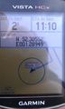
- Arrived. -- Sourcerer (talk) @52.3055,1.2895 11:05, 30 January 2015 (GMT)
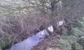
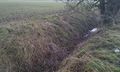
This was 25km from home and easily reached on roads covered in a mixture of water, mud and ice. There was dry parking right by the start of the public footpath. The hashpoint was about 470 metres away. There were a couple of icy footbridges to add a bit of danger and excitement. Close to the hashpoint, the path was on the wrong side of a deep wet drainage ditch with a mature hedge of hawthorn, blackthorn and dog rose thorn - all impenetrable without a machete which I prefer not to carry!
About 130 metres further along the path there was a place to cross the ditch and there was a gap in the hedge. The ditch was nearly two metres deep and the only safe way down was a back side slide resulting in a muddy bum and nettle stings on the palms of my hands. The things we to for our sport!
An easy backtrack took me to the hashpoint for photos and message posting. Then the whole walk was done in reverse without further incident but quite a lot more mud.
I was not aware that ChromeCrusaders planned to go later that day, in the dark, in poor weather and with no previous experience. It's interesting to see the steep learning curve of new geohashers. Welcome!
Photos

Track reconstruction
Proof
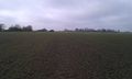
View from the Hashpoint
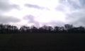
View from the Hashpoint
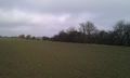
View from the Hashpoint
Thorns and water barrier
A Crossing Point


Achievements (Sourcerer)
I added the drainage ditches to Openstreetmap correcting and making the footpath crossing points clear.
Sourcerer earned the OpenStreetMap achievement
|
Achievements (ChromeCrusaders)
ChromeCrusaders (talk) earned the Blinded by Science Consolation Prize
|
Is it true that ChromeCrusaders (talk) earned the Train wreck?
|
Expeditions and Plans
| 2015-01-30 | ||
|---|---|---|
| Mannheim, Germany | DODO | In the forest between Hahnhofen and Geinsheim, next to the leisure park Hol... |
| Norwich, United Kingdom | Sourcerer, ChromeCrusaders | In a field close to a public footpath north east of Wilby, Suffolk, UK. |
Sourcerer's Expedition Links
2015-01-29 52 0 - 2015-01-30 52 1 - 2015-01-31 52 1 - KML file download of Sourcerer's expeditions for use with Google Earth.