Difference between revisions of "2015-02-17 52 0"
From Geohashing
imported>Sourcerer m (→Added Achievement) |
imported>FippeBot m (Location) |
||
| (5 intermediate revisions by one other user not shown) | |||
| Line 3: | Line 3: | ||
| lon=0 | | lon=0 | ||
| date=2015-02-17 | | date=2015-02-17 | ||
| + | | graticule_name=Cambridge, UK | ||
| + | | graticule_link=Cambridge, United Kingdom | ||
}} | }} | ||
| − | |||
__NOTOC__ | __NOTOC__ | ||
== Location == | == Location == | ||
| − | + | In a field just south of the river Lark, Pinford End, Suffolk, UK. | |
== Participants == | == Participants == | ||
| Line 20: | Line 21: | ||
== Expedition == | == Expedition == | ||
| + | There was a handy place to park. The route followed a field perimeter and tractor tracks with a few paces into the crop at the end. It was a dark starry night without any moon light. There was no 3G signal. | ||
| − | + | Earlier I added two footpaths, located next to the hashpoint, to OpenStreetMap. | |
| − | |||
== Photos == | == Photos == | ||
<gallery perrow="5"> | <gallery perrow="5"> | ||
| + | Image:2015-02-17 52 0 Sourcerer 1.jpg | Proof | ||
| + | Image:2015-02-17 52 0 Sourcerer 2.jpg | Track Log | ||
</gallery> | </gallery> | ||
| Line 40: | Line 43: | ||
}} | }} | ||
| − | == | + | {{Sourcerer_links |
| − | + | | prev = 2015-02-16 52 1 | |
| − | + | | curr = 2015-02-17 52 0 | |
| − | + | | next = 2015-02-18 52 0 | |
| − | + | | date = 2015-02-17 | |
| + | }} | ||
| − | |||
[[Category:Expeditions]] | [[Category:Expeditions]] | ||
| − | |||
[[Category:Expeditions with photos]] | [[Category:Expeditions with photos]] | ||
| − | |||
| − | |||
| − | |||
| − | |||
| − | |||
[[Category:Coordinates reached]] | [[Category:Coordinates reached]] | ||
| − | + | {{location|GB|ENG|SFK}} | |
| − | |||
| − | |||
| − | |||
| − | |||
| − | |||
| − | |||
| − | |||
| − | |||
| − | |||
| − | |||
| − | |||
| − | |||
| − | |||
| − | |||
| − | |||
| − | |||
| − | |||
Latest revision as of 02:46, 15 August 2019
| Tue 17 Feb 2015 in Cambridge, UK: 52.2039566, 0.7073702 geohashing.info google osm bing/os kml crox |
Location
In a field just south of the river Lark, Pinford End, Suffolk, UK.
Participants
Plans
Drat - the Norwich points are in the sea. Have to do Cambridge then! This could be paired with 2015-02-18 52 0 spanning midnight.
Expedition
There was a handy place to park. The route followed a field perimeter and tractor tracks with a few paces into the crop at the end. It was a dark starry night without any moon light. There was no 3G signal.
Earlier I added two footpaths, located next to the hashpoint, to OpenStreetMap.
Photos
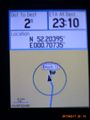
Proof
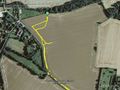
Track Log


Achievements
Sourcerer earned the OpenStreetMap achievement
|
Expeditions and Plans
| 2015-02-17 | ||
|---|---|---|
| München, Germany | TheOneRing | in a grove somewhere near Unterföhring. |
| Kassel, Germany | GeorgDerReisende | In the frontyard of a house in Hessisch Lichtenau. |
| Cambridge, United Kingdom | Sourcerer | In a field just south of the river Lark, Pinford End, Suffolk, UK. |
Sourcerer's Expedition Links
2015-02-16 52 1 - 2015-02-17 52 0 - 2015-02-18 52 0 - KML file download of Sourcerer's expeditions for use with Google Earth.