Difference between revisions of "2015-09-20 52 0"
From Geohashing
imported>Sourcerer m ([live] Arrived.) |
imported>FippeBot m (Location) |
||
| (4 intermediate revisions by one other user not shown) | |||
| Line 3: | Line 3: | ||
| lon=0 | | lon=0 | ||
| date=2015-09-20 | | date=2015-09-20 | ||
| + | | graticule_name=Cambridge, UK | ||
| + | | graticule_link=Cambridge, United Kingdom | ||
}} | }} | ||
__NOTOC__ | __NOTOC__ | ||
| − | |||
== Location == | == Location == | ||
| Line 20: | Line 21: | ||
== Expedition == | == Expedition == | ||
| + | *Arrived. -- [[User:Sourcerer|Sourcerer]] ([[User talk:Sourcerer|talk]]) [http://www.openstreetmap.org/?lat=52.84893751&lon=.92476130&zoom=16&layers=B000FTF @52.8489,.9248] 23:06, 20 September 2015 (GMT+01:00) | ||
| + | From the road, the distance was 7 or 8 metres. I walked into the field and from the other side of the hedge, the distance dropped to 2 metres. | ||
| − | |||
| − | |||
== Photos == | == Photos == | ||
<gallery perrow="5"> | <gallery perrow="5"> | ||
| + | Image:2015-09-20_52_0_Sourcerer_1442786724498.jpg | Proof [http://www.openstreetmap.org/?lat=52.84893751&lon=.92475593&zoom=16&layers=B000FTF @52.8489,.9248] | ||
| + | Image:2015-09-20 52 0 Sourcerer.jpg | Google Earth Track | ||
</gallery> | </gallery> | ||
| Line 39: | Line 42: | ||
}} | }} | ||
| − | |||
| − | |||
[[Category:Expeditions]] | [[Category:Expeditions]] | ||
[[Category:Expeditions with photos]] | [[Category:Expeditions with photos]] | ||
[[Category:Coordinates reached]] | [[Category:Coordinates reached]] | ||
| − | + | {{location|GB|ENG|NFK}} | |
Latest revision as of 05:12, 15 August 2019
| Sun 20 Sep 2015 in Cambridge, UK: 52.8488893, 0.9247735 geohashing.info google osm bing/os kml crox |
Location
A field perimeter close to Little Snoring, Norfolk, UK.
Participants
Plans
Expedition one of two spanning midnight - 2015-09-20 52 0 - 2015-09-21 52 0 - ETA 23:10.
Expedition
- Arrived. -- Sourcerer (talk) @52.8489,.9248 23:06, 20 September 2015 (GMT+01:00)
From the road, the distance was 7 or 8 metres. I walked into the field and from the other side of the hedge, the distance dropped to 2 metres.
Photos

Proof @52.8489,.9248
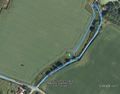
Google Earth Track


Achievements
Expeditions and Plans
| 2015-09-20 | ||
|---|---|---|
| Cruz del Eje, Argentina | Onicofago | In some bushes in a field near Villa de Soto. Córdoba, Argentina. |
| Dallas, Texas | Chandru | In a nature area between the University of Dallas and Highway 114. |
| New York, New York | OtherJack | Aboard a moving train in the Bronx |
| Chicago, Illinois | Haberdasher | A parking lot in Oak Brook. |
| Livorno, Italy | pah, NB | In a backyard in Forrottoli, a small village in Tuscany. |
| Würzburg, Germany | Gefrierbrand | On a quite steep field near a collection of trees which weren't quite numer... |
| Cambridge, United Kingdom | Sourcerer | A field perimeter close to Little Snoring, Norfolk, UK. |
| Moscow, Russia | Alexey Nigin | That Geohash is located within the Losiniy Ostrov National Park (Национальн... |
Sourcerer's Expedition Links
2015-09-16 52 1 - 2015-09-20 52 0 - 2015-09-21 52 0 - KML file download of Sourcerer's expeditions for use with Google Earth.