Difference between revisions of "2015-09-26 52 0"
From Geohashing
imported>Sourcerer m (→Achievements) |
imported>FippeBot m (Location) |
||
| (5 intermediate revisions by one other user not shown) | |||
| Line 3: | Line 3: | ||
| lon=0 | | lon=0 | ||
| date=2015-09-26 | | date=2015-09-26 | ||
| + | | graticule_name=Cambridge, UK | ||
| + | | graticule_link=Cambridge, United Kingdom | ||
}} | }} | ||
__NOTOC__ | __NOTOC__ | ||
| − | |||
== Location == | == Location == | ||
| − | In a field with public footpaths close by, north of Hadfield, Suffolk, UK.[http://w3w.co/wings.recruiter.discussed w3w] | + | In a field, with public footpaths close by, north of Hadfield, Suffolk, UK.[http://w3w.co/wings.recruiter.discussed w3w] |
== Participants == | == Participants == | ||
| Line 16: | Line 17: | ||
== Plans == | == Plans == | ||
| − | Expedition one of two spanning midnight - [[2015-09-26 52 0]] - [[2015-09-27 52 1]] - Eta | + | Expedition one of two spanning midnight - [[2015-09-26 52 0]] - [[2015-09-27 52 1]] - Eta 23:05. |
== Expedition == | == Expedition == | ||
| + | *Arrived. -- [[User:Sourcerer|Sourcerer]] ([[User talk:Sourcerer|talk]]) [http://www.openstreetmap.org/?lat=52.07380593&lon=.95856249&zoom=16&layers=B000FTF @52.0738,.9586] 23:20, 26 September 2015 (GMT+01:00) | ||
| + | A closed road caused quite a significant delay. Then I forgot my mental image of the terrain and took a roundabout path to the hashpoint which was in a field of newly germinated oil seed rape. It was easy to avoid the little plants. The moon was nearly full and it was cool at 8C. The eclipse was about 30 hours away. | ||
== Photos == | == Photos == | ||
| + | |||
<gallery> | <gallery> | ||
| + | Image:2015-09-26_52_0_Sourcerer_1443306105562.jpg | Proof. [http://www.openstreetmap.org/?lat=52.07381129&lon=.95855713&zoom=16&layers=B000FTF @52.0738,.9586] | ||
| + | Image:2015-09-26 52 0 Sourcerer.jpg | Track in Google Earth | ||
</gallery> | </gallery> | ||
| Line 44: | Line 50: | ||
}} | }} | ||
| − | |||
| − | |||
[[Category:Expeditions]] | [[Category:Expeditions]] | ||
[[Category:Expeditions with photos]] | [[Category:Expeditions with photos]] | ||
| − | [[Category:Coordinates | + | [[Category:Coordinates reached]] |
| − | + | {{location|GB|ENG|SFK}} | |
Latest revision as of 05:16, 15 August 2019
| Sat 26 Sep 2015 in Cambridge, UK: 52.0737960, 0.9585734 geohashing.info google osm bing/os kml crox |
Location
In a field, with public footpaths close by, north of Hadfield, Suffolk, UK.w3w
Participants
Plans
Expedition one of two spanning midnight - 2015-09-26 52 0 - 2015-09-27 52 1 - Eta 23:05.
Expedition
- Arrived. -- Sourcerer (talk) @52.0738,.9586 23:20, 26 September 2015 (GMT+01:00)
A closed road caused quite a significant delay. Then I forgot my mental image of the terrain and took a roundabout path to the hashpoint which was in a field of newly germinated oil seed rape. It was easy to avoid the little plants. The moon was nearly full and it was cool at 8C. The eclipse was about 30 hours away.
Photos
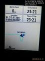
Proof. @52.0738,.9586
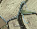
Track in Google Earth


Achievements
Sourcerer earned the OpenStreetMap achievement
|
Expeditions and Plans
| 2015-09-26 | ||
|---|---|---|
| St. Louis, Missouri | Kbh3rd | In the Pea Ridge Conservation Area northwest of Potosi. |
| Baltimore, Maryland | Pedalpusher | In Fairland, MD, next to an exit road for a Verizon Office building |
| Lewiston, Idaho | Thomcat | Just east of Rogersburg WA on the banks of the Snake River. |
| Kraków, Poland | Malgond | On a crosswalk in Beliny-Prażmowskiego Street in Kraków. |
| Düsseldorf, Germany | Danatar | in an empty sheep pasture in Langenfeld-Mehlbruch, near Leverkusen. Countr... |
| Cambridge, United Kingdom | Sourcerer | In a field, with public footpaths close by, north of Hadfield, Suffolk, UK.... |
| Amsterdam, Netherlands | JwB | Farmland near Harmelen |
Sourcerer's Expedition Links
2015-09-25 52 1 - 2015-09-26 52 0 - 2015-09-27 52 1 - KML file download of Sourcerer's expeditions for use with Google Earth.