Difference between revisions of "2017-02-11 52 1"
imported>Sourcerer m ([live picture] Arrived. [http://www.openstreetmap.org/?lat=52.02677608&lon=1.13909662&zoom=16&layers=B000FTF @52.0268,1.1391]) |
imported>Sourcerer m (→New expedition) |
||
| Line 1: | Line 1: | ||
| − | + | {{meetup graticule | |
| − | |||
| − | |||
| − | |||
| − | |||
| − | |||
| − | |||
| − | |||
| − | |||
| − | |||
| − | {{meetup graticule | ||
| lat=52 | | lat=52 | ||
| lon=1 | | lon=1 | ||
| date=2017-02-11 | | date=2017-02-11 | ||
| + | | graticule_name=Norwich, UK | ||
| + | | graticule_link=Norwich, United Kingdom | ||
}} | }} | ||
| − | |||
| − | |||
__NOTOC__ | __NOTOC__ | ||
| + | == Location == | ||
| − | + | West of the dry ski slopes, south of Ipswich, Suffolk, UK. | |
| − | |||
== Participants == | == Participants == | ||
| − | + | ||
| − | + | [[User:Sourcerer|Sourcerer]] | |
== Plans == | == Plans == | ||
| − | + | ||
| + | Two of two spanning midnight [[2017-02-10 52 1]] - [[2017-02-11 52 1]] - ETA 00:00. | ||
== Expedition == | == Expedition == | ||
| − | |||
| − | + | This was easy enough but I managed to take a wrong turning and did a bit more driving than really necessary. There was a place to park near the top of the ski slopes. The road was gated for cars but open for cyclists and walkers. This led to a public footpath. There was access to the field over a low wire. Tractor tracks led to the hashpoint. | |
| − | |||
| − | + | It was still snowing and the cloud was even lower. At Mendlesham on the route home, the TV mast was shrouded in low cloud and only the bottom two sets of lights could be seen. The top three were completely hidden. So much for lunar eclipse spotting. | |
| − | |||
| − | |||
| − | |||
| − | |||
| + | == Photos == | ||
| + | <gallery caption="Gallery" widths="200px" heights="200px" perrow="3"> | ||
| + | Image:2017-02-11 52 1 Sourcerer.jpg | Google Earth Track | ||
Image:2017-02-11_52_1_Sourcerer_1486771247210.jpg | Arrived. [http://www.openstreetmap.org/?lat=52.02677608&lon=1.13909662&zoom=16&layers=B000FTF @52.0268,1.1391] | Image:2017-02-11_52_1_Sourcerer_1486771247210.jpg | Arrived. [http://www.openstreetmap.org/?lat=52.02677608&lon=1.13909662&zoom=16&layers=B000FTF @52.0268,1.1391] | ||
</gallery> | </gallery> | ||
| Line 45: | Line 33: | ||
== Achievements == | == Achievements == | ||
{{#vardefine:ribbonwidth|800px}} | {{#vardefine:ribbonwidth|800px}} | ||
| − | |||
| − | + | {{Sourcerer_links | |
| − | + | | prev = 2017-02-10 52 1 | |
| − | + | | curr = 2017-02-11 52 1 | |
| − | + | | next = 2017-02-12 52 1 | |
| − | + | | date = 2017-02-11 | |
| − | + | }} | |
| − | |||
| − | |||
| − | |||
| − | -- | ||
| − | |||
| − | |||
| − | |||
[[Category:Expeditions]] | [[Category:Expeditions]] | ||
| − | |||
[[Category:Expeditions with photos]] | [[Category:Expeditions with photos]] | ||
| − | |||
| − | |||
| − | |||
| − | |||
| − | |||
[[Category:Coordinates reached]] | [[Category:Coordinates reached]] | ||
| − | |||
| − | |||
| − | |||
| − | |||
| − | |||
| − | |||
| − | |||
| − | |||
| − | |||
| − | |||
| − | |||
| − | |||
| − | |||
| − | |||
| − | |||
| − | |||
| − | |||
| − | |||
Revision as of 01:57, 11 February 2017
| Sat 11 Feb 2017 in Norwich, UK: 52.0267686, 1.1390999 geohashing.info google osm bing/os kml crox |
Location
West of the dry ski slopes, south of Ipswich, Suffolk, UK.
Participants
Plans
Two of two spanning midnight 2017-02-10 52 1 - 2017-02-11 52 1 - ETA 00:00.
Expedition
This was easy enough but I managed to take a wrong turning and did a bit more driving than really necessary. There was a place to park near the top of the ski slopes. The road was gated for cars but open for cyclists and walkers. This led to a public footpath. There was access to the field over a low wire. Tractor tracks led to the hashpoint.
It was still snowing and the cloud was even lower. At Mendlesham on the route home, the TV mast was shrouded in low cloud and only the bottom two sets of lights could be seen. The top three were completely hidden. So much for lunar eclipse spotting.
Photos
- Gallery
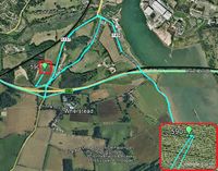
Google Earth Track
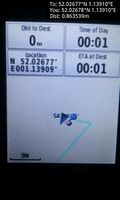
Arrived. @52.0268,1.1391


Achievements
Expeditions and Plans
| 2017-02-11 | ||
|---|---|---|
| Roswell, Georgia | NWoodruff | In a dog park in John's Creek. |
| St. Louis, Missouri | Kbh3rd, his lovely bride. | The meetup point is deep in the woods off the trail in Magnolia Hollow Conservation Area... |
| Norwich, United Kingdom | Sourcerer | West of the dry ski slopes, south of Ipswich, Suffolk, UK. |
Sourcerer's Expedition Links
2017-02-10 52 1 - 2017-02-11 52 1 - 2017-02-12 52 1 - KML file download of Sourcerer's expeditions for use with Google Earth.