Difference between revisions of "2017-09-16 39 -105"
imported>Whoa Knock ([live picture]At the meet-up [http://www.openstreetmap.org/?lat=39.88896270&lon=-105.15864450&zoom=16&layers=B000FTF @39.8890,-105.1586]) |
imported>FippeBot m (Location) |
||
| (17 intermediate revisions by 2 users not shown) | |||
| Line 15: | Line 15: | ||
}} | }} | ||
| − | |||
__NOTOC__ | __NOTOC__ | ||
== Location == | == Location == | ||
| − | + | Saturday Meet-up within the Colorado Hills Open Space - a large open area that is essentially a huge dog park. Almost no trees and only knee-high brush at most. Very easy run. | |
== Participants == | == Participants == | ||
| − | + | * [[User:Whoa_Knock|Whoa Knock]] | |
| − | - | + | |
| + | == Expedition == | ||
| + | The hike in was very easy, following the Westminster Hills Trail. I stopped for two quick geocaches ([https://www.geocaching.com/geocache/GCV42G_mondos-small-world Mondo's Small World] & [https://www.geocaching.com/geocache/GC3AZKA_yucca-poo yucca poo!])along the way. I mis-interpreted my directions of "Turn at the intersecting power lines" when I should had written "Turn at the second set of intersecting power lines". I bush-wacked part of the way before coming to a small trail. The rest of the way was easy, punctuated by friendly dogs every few minutes (the park is no leash, so the dogs and owners love it). | ||
| − | + | Arrived with a few minutes to spare and enjoyed the view of the Front Range. Also found trash (deflated mylar balloon) which I packed out. | |
| − | |||
| − | + | Took photos at the Meet-up time and hustled back since something I ate this morning really wanted to get out... just made the port-potty in time (no good places to hide and drop). | |
| − | |||
| − | + | My first Saturday meet-up - WOOT!!!! | |
| − | |||
== Photos == | == Photos == | ||
| Line 42: | Line 40: | ||
Image:2017-09-16_39_-105_Whoa Knock_1505599058667.jpg|39 N 105 W meetup [http://www.openstreetmap.org/?lat=39.88896960&lon=-105.15863500&zoom=16&layers=B000FTF @39.8890,-105.1586] | Image:2017-09-16_39_-105_Whoa Knock_1505599058667.jpg|39 N 105 W meetup [http://www.openstreetmap.org/?lat=39.88896960&lon=-105.15863500&zoom=16&layers=B000FTF @39.8890,-105.1586] | ||
| − | Image:2017-09-16_39_-105_Whoa Knock_1505599264836.jpg| | + | Image:2017-09-16_39_-105_Whoa Knock_1505599264836.jpg|Proof |
| + | |||
| + | Image:2017-09-16_39_-105_Whoa Knock_Front Range.jpg|The Front Range | ||
| + | |||
| + | Image:2017-09-16_39_-105_Whoa Knock_Tick Check.jpg|Post-run Tick Check; Yeah, I hike expeditions in red socks and a red shirt - I live dangerously... s#@!, there's [https://cnet2.cbsistatic.com/img/hEZpPXputZgAhLRjXb389WG2ri4=/fit-in/970x0/2017/03/21/7e9516fc-90e1-4f66-8123-ec4da5e8e1b6/kirkcropbirthday.jpg Kirk] | ||
| + | |||
</gallery> | </gallery> | ||
== Achievements == | == Achievements == | ||
{{#vardefine:ribbonwidth|800px}} | {{#vardefine:ribbonwidth|800px}} | ||
| − | |||
| − | + | {{Geotrash | |
| − | + | | latitude = 39 | |
| − | + | | longitude = -105 | |
| + | | date = 2017-09-16 | ||
| + | | name = Whoa Knock | ||
| + | | image = 2017-09-16_39_-105_Whoa Knock_Trash.jpg }} | ||
| − | + | {{Easy_geohash | latitude = 39 | longitude = -105 | date = 2017-09-16 }} | |
| − | + | {{xkcd centurion | |
| − | + | | count = 1 | |
| − | + | | name = Whoa Knock | |
| − | + | }} | |
| − | |||
| − | |||
[[Category:Expeditions]] | [[Category:Expeditions]] | ||
| − | + | ||
[[Category:Expeditions with photos]] | [[Category:Expeditions with photos]] | ||
| − | + | ||
| − | |||
| − | |||
| − | |||
| − | |||
[[Category:Coordinates reached]] | [[Category:Coordinates reached]] | ||
| − | + | {{location|US|CO|JE}} | |
| − | |||
| − | |||
| − | |||
| − | |||
| − | |||
| − | |||
| − | |||
| − | |||
| − | |||
| − | |||
| − | |||
| − | |||
| − | |||
| − | |||
| − | |||
| − | |||
| − | |||
Latest revision as of 02:58, 16 August 2019
| Sat 16 Sep 2017 in 39,-105: 39.8889697, -105.1586446 geohashing.info google osm bing/os kml crox |
Location
Saturday Meet-up within the Colorado Hills Open Space - a large open area that is essentially a huge dog park. Almost no trees and only knee-high brush at most. Very easy run.
Participants
Expedition
The hike in was very easy, following the Westminster Hills Trail. I stopped for two quick geocaches (Mondo's Small World & yucca poo!)along the way. I mis-interpreted my directions of "Turn at the intersecting power lines" when I should had written "Turn at the second set of intersecting power lines". I bush-wacked part of the way before coming to a small trail. The rest of the way was easy, punctuated by friendly dogs every few minutes (the park is no leash, so the dogs and owners love it).
Arrived with a few minutes to spare and enjoyed the view of the Front Range. Also found trash (deflated mylar balloon) which I packed out.
Took photos at the Meet-up time and hustled back since something I ate this morning really wanted to get out... just made the port-potty in time (no good places to hide and drop).
My first Saturday meet-up - WOOT!!!!
Photos
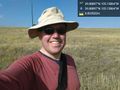
39 N 105 W meetup @39.8890,-105.1586

Proof
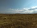
The Front Range

Post-run Tick Check; Yeah, I hike expeditions in red socks and a red shirt - I live dangerously... s#@!, there's Kirk


Achievements
Whoa Knock earned the GeoTrash Geohash Achievement
|
This user has visited an Easy Geohash
|
Whoa Knock earned the xkcd Nullaturion achievement
|